|
Bichhar Pass
Bichhar pass (el. ) is a high mountain pass at the boundary of the Ghizer and Gilgit districts in Gilgit–Baltistan of Pakistan. To the north of the pass is Bichhari village in the Naltar valley in Gilgit district. To the south of the pass is the village Sherqila on the Gilgit Gilgit (; Shina: ; ur, ) is the capital city of Gilgit–Baltistan, Pakistan. The city is located in a broad valley near the confluence of the Gilgit River and the Hunza River. It is a major tourist destination in Pakistan, serving as a h ... river in the Ghizer district. Mountain passes of Gilgit-Baltistan {{NorthernAreas-geo-stub ... [...More Info...] [...Related Items...] OR: [Wikipedia] [Google] [Baidu] |
Gilgit–Baltistan
Gilgit-Baltistan (; ), formerly known as the Northern Areas, is a region administered by Pakistan as an administrative territory, and constituting the northern portion of the larger Kashmir region which has been the subject of a dispute between India and Pakistan since 1947, and between India and China from somewhat later.The application of the term "administered" to the various regions of Kashmir and a mention of the Kashmir dispute is supported by the tertiary sources (a) through (d), reflecting due weight in the coverage. Although "controlled" and "held" are also applied neutrally to the names of the disputants or to the regions administered by them, as evidenced in sources (e) through (g) below, "held" is also considered politicized usage, as is the term "occupied," (see (h) below): (a) (subscription required) Quote: "Kashmir, region of the northwestern Indian subcontinent ... has been the subject of dispute between India and Pakistan since the partition of the Indi ... [...More Info...] [...Related Items...] OR: [Wikipedia] [Google] [Baidu] |
Pakistan
Pakistan ( ur, ), officially the Islamic Republic of Pakistan ( ur, , label=none), is a country in South Asia. It is the world's List of countries and dependencies by population, fifth-most populous country, with a population of almost 243 million people, and has the world's Islam by country#Countries, second-largest Muslim population just behind Indonesia. Pakistan is the List of countries and dependencies by area, 33rd-largest country in the world by area and 2nd largest in South Asia, spanning . It has a coastline along the Arabian Sea and Gulf of Oman in the south, and is bordered by India to India–Pakistan border, the east, Afghanistan to Durand Line, the west, Iran to Iran–Pakistan border, the southwest, and China to China–Pakistan border, the northeast. It is separated narrowly from Tajikistan by Afghanistan's Wakhan Corridor in the north, and also shares a maritime border with Oman. Islamabad is the nation's capital, while Karachi is its largest city and fina ... [...More Info...] [...Related Items...] OR: [Wikipedia] [Google] [Baidu] |
Hindukush Mountains
The Hindu Kush is an mountain range in Central and South Asia to the west of the Himalayas. It stretches from central and western Afghanistan, Quote: "The Hindu Kush mountains run along the Afghan border with the North-West Frontier Province of Pakistan". into northwestern Pakistan and far southeastern Tajikistan. The range forms the western section of the ''Hindu Kush Himalayan Region'' (''HKH''); to the north, near its northeastern end, the Hindu Kush buttresses the Pamir Mountains near the point where the borders of China, Pakistan and Afghanistan meet, after which it runs southwest through Pakistan and into Afghanistan near their border. The eastern end of the Hindu Kush in the north merges with the Karakoram Range.Karakoram Range: MOUNTAINS, ASIA Encyclopædia Britannica Towards its sou ... [...More Info...] [...Related Items...] OR: [Wikipedia] [Google] [Baidu] |
Mountain Pass
A mountain pass is a navigable route through a mountain range or over a ridge. Since many of the world's mountain ranges have presented formidable barriers to travel, passes have played a key role in trade, war, and both Human migration, human and animal migration throughout history. At lower elevations it may be called a hill pass. A mountain pass is typically formed between two volcanic peaks or created by erosion from water or wind. Overview Mountain passes make use of a gap (landform), gap, saddle (landform), saddle, col or notch (landform), notch. A topographic saddle is analogous to the mathematical concept of a saddle surface, with a saddle point marking the highest point between two valleys and the lowest point along a ridge. On a topographic map, passes are characterized by contour lines with an hourglass shape, which indicates a low spot between two higher points. In the high mountains, a difference of between the summit and the mountain is defined as a mountain pas ... [...More Info...] [...Related Items...] OR: [Wikipedia] [Google] [Baidu] |
Ghizer District (2019–)
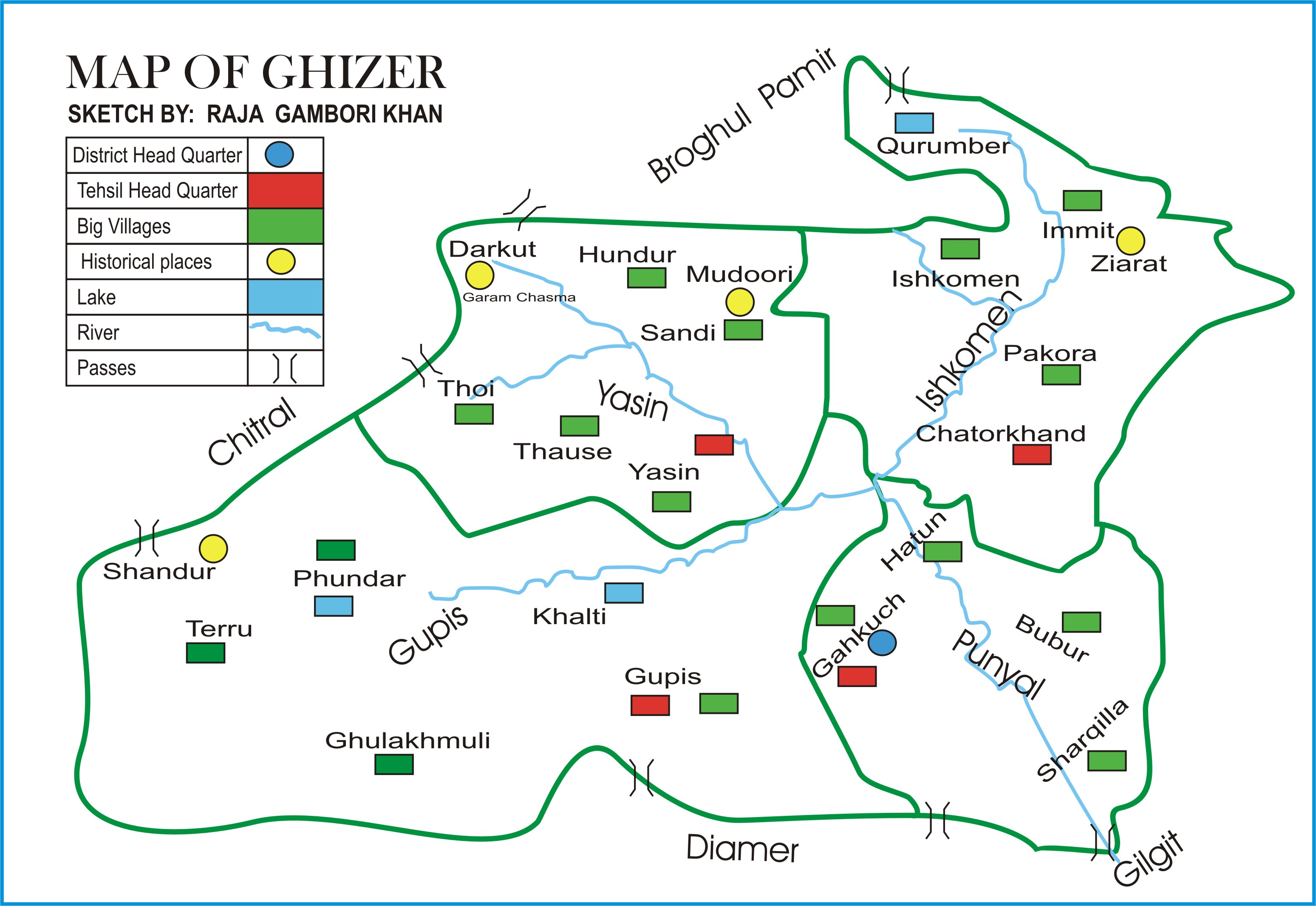
The Ghizer District ( ur, ) is one of the 14 districts of Pakistan-administered territory of Gilgit-Baltistan. The former Ghizer District that existed from 1974 to 2019 spanned the entire upper Gilgit River Valley (also known as the Ghizer River Valley). In 2019, the former district was divided into the Gupis-Yasin District in the west and the present, smaller Ghizer District in the east. The word Ghizer came from the name "Gherz" which means "refugees" in Khowar. "Gherz" is a village in Golaghmuli Valley. The Chitral State under the suzerainty of the British Raj forced some people to migrate towards Gupis, Yasin, Phander, Ishkomen and also to Punial. They were settled in the area between Chitral and Gupis. The area came to be called "Gherz" and the people "Gherzic". Ghizer District comprised Punial, Gupis, Yasen, Phander and Ishkoman Valleys. The major portion of its area was ruled over by Brooshay Rajas. Currently, the living Raja families in the District have no administrat ... [...More Info...] [...Related Items...] OR: [Wikipedia] [Google] [Baidu] |
Gilgit District
The Gilgit District ( ur, ) is one of the 14 districts of Pakistan-administered territory of Gilgit-Baltistan. The headquarters of the district is the town of Gilgit. According to the 1998 census, the Gilgit District had a population of 243,324. The district includes Gilgit (the capital city), the Bagrot Valley, Juglot, Danyore, Sultanabad, Naltar Peak, and the Nomal Valley. The highest peak in the district is Distaghil Sar , which is the seventh-highest peak in Pakistan and 19th highest in the world. Administration The Gilgit District is divided into three tehsils: * Danyor Tehsil * Gilgit Tehsil * Juglot Tehsil Education According to the Alif Ailaan Pakistan District Education Rankings 2015, the Gilgit District was ranked 35th out of 148 districts in terms of education. In terms of facilities and infrastructure, the district was ranked 67th out of 148. Geography The Gilgit District is bounded on the north by the Nagar District, on the east by the Shigar Distr ... [...More Info...] [...Related Items...] OR: [Wikipedia] [Google] [Baidu] |
Naltar Valley
The Naltar Valley () is a valley situated about from the city of Gilgit in Gilgit-Baltistan, Gilgit−Baltistan, Pakistan. It is a forested region known for its dramatic mountain scenery and for its three lakes: Strangi Lake, Blue Lake, and Bodlok Lake. Ski competitions are held at Naltar ski resort. Geography The Naltar Valley is a valley situated near the city of Gilgit in Gilgit-Baltistan, Gilgit−Baltistan, Pakistan. Naltar is about from Gilgit. Naltar Bala (upper) and Naltar Paain (lower) are two villages of Naltar valley. Naltar Paain is at a distance of and Naltar Bala at from Gilgit. Naltar Expressway connects Naltar with Gilgit City via Nomal and Faizabad. There is a town known as Nomal between Naltar valley and Gilgit. A road from Nomal goes to 'The Silk Route' to China. Naltar Hydropower Projects (I, II, IV) The government has constructed an 18 MW hydropower plant, Naltar Hydropower Plant-IV, which is operational since October 2007, near Naltar Pine, in addi ... [...More Info...] [...Related Items...] OR: [Wikipedia] [Google] [Baidu] |
Gilgit River
The Gilgit River () is a tributary of the Indus River, and flows through the Gupis-Yasin, Ghizer and Gilgit districts of Gilgit-Baltistan. The Gilgit River starts from Shandur Lake, and joins the Indus River at near towns of Juglot and Bunji, where also the three mountain ranges of Hindu Kush, Himalaya and Karakoram ranges are believed to meet. The upper sections of the Gilgit river are called Gupis River and Ghizer River. See also *Shandur Pass Shandur Pass( ur, ) is a pass located in Ghizer, District of Gilgit Baltistan . It is often called 'Roof of the World. During the annual ' Shandur Polo Festival,' there are polo matches played in Shandur Polo Ground on Shandur Top, between the ... References Tributaries of the Indus River Rivers of Gilgit-Baltistan Karakoram Rivers of Pakistan {{Pakistan-river-stub ... [...More Info...] [...Related Items...] OR: [Wikipedia] [Google] [Baidu] |


