|
Bauerfield International Airport
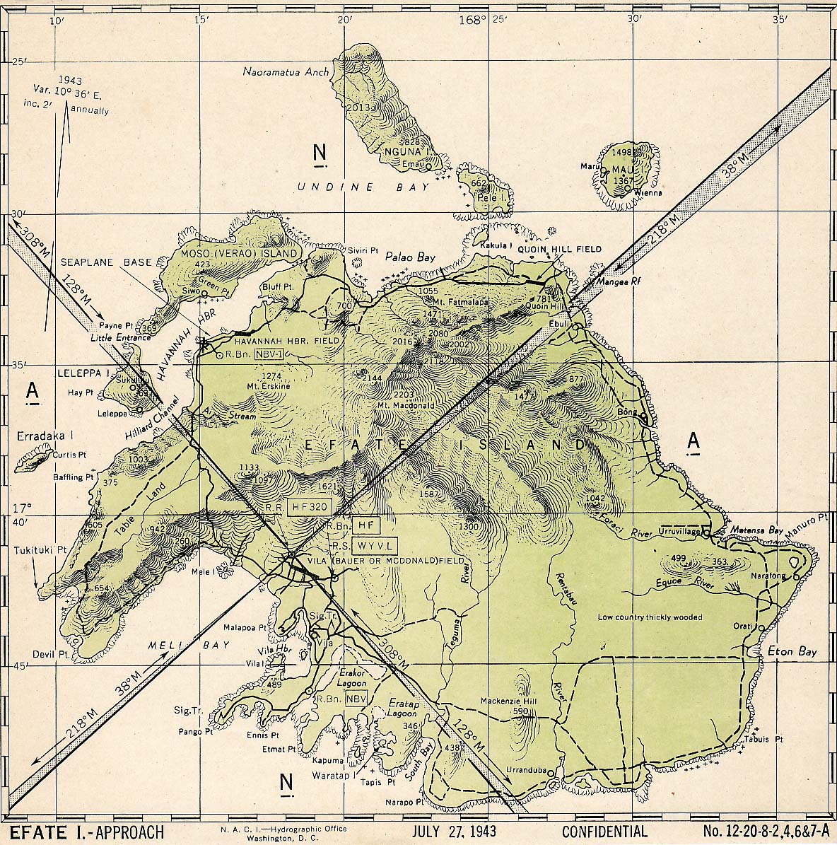
Bauerfield International Airport (french: Aéroport International Bauerfield) is an airport located in Port Vila, Vanuatu. The airport is relatively small in size, but its runway has the capability and length to accept jets up to the Airbus A330. It serves as the hub for Vanuatu's flag carrier airline, Air Vanuatu. History With Japanese forces establishing bases on Guadalcanal which threatened the sea route between the U.S. and Australia, Admiral King distributed the joint basic plan for the occupation and defense of Efate (the island containing Port Vila) on 20 March 1942. Under its terms the US Army was to defend Efate and support the defense of ships and positions. The US Navy's task was: (1) to construct, administer and operate a naval advance base, seaplane base, and harbor facilities; (2) to support Army forces in the defense of the island; (3) to construct an airfield and at least two outlying dispersal fields; (4) to provide facilities for the operation of seaplane-bomber ... [...More Info...] [...Related Items...] OR: [Wikipedia] [Google] [Baidu] |
Port Vila
Port Vila (french: Port-Vila), or simply Vila (; french: Vila; bi, Vila ), is the capital and largest city of Vanuatu. It is located on the island of Efate. Its population in the last census (2009) was 44,040, an increase of 35% on the previous census result (29,356 in 1999). In 2009, the population of Port Vila formed 18.8% of the country's population, and 66.9% of the population of Efate. On the south coast of the island of Efate, in Shefa Province, Port Vila is the economic and commercial centre of Vanuatu. The mayor is Erick Puyo Festa, of the Vanua'aku Pati, elected in January 2018; his deputy is Jenny Regenvanu, of the Graun mo Jastis Pati. On 13 March 2015, Port Vila bore extensive damage from Cyclone Pam. Name Locally the town is most commonly referred to simply as "Vila", whether in French or Bislama or in English (not like English "villa"). The name of the area is ''Efil'' in the native South Efate language and ''Ifira'' in neighbouring Mele-Fila languag ... [...More Info...] [...Related Items...] OR: [Wikipedia] [Google] [Baidu] |
Aircalin
Société Aircalin, also known as Air Calédonie International, is the flag carrier of the French collectivity of New Caledonia, with its headquarters in Nouméa. It operates scheduled services from its main base at La Tontouta International Airport to destinations across Oceania and Asia, such as Japan and Singapore, and additionally operates domestic services in Wallis and Futuna. The airline is 99% owned by the Government of New Caledonia, with the remaining 1% held by minority owners, including the airline's employees. History The airline was established in September 1983 as ''Air Calédonie International'', an international airline to complement New Caledonia's domestic airline, Air Calédonie. Between 1983 and 1985, the airline operated flights from Nouméa by leasing aircraft from other airlines including Air Nauru and Qantas. In 1985, the airline acquired a Sud Aviation Caravelle from Corsair, which it used to open routes to Sydney and Auckland until 1988, when the ... [...More Info...] [...Related Items...] OR: [Wikipedia] [Google] [Baidu] |
Melbourne Airport
Melbourne Airport , colloquially known as Tullamarine Airport, is the primary airport serving the city of Melbourne, and the second busiest airport in Australia. It opened in 1970 to replace the nearby Essendon Airport. Melbourne Airport is the main international airport of the four airports serving the Melbourne metropolitan area, the other international airport being Avalon Airport. The airport comprises four terminals: one international terminal, two domestic terminals and one budget domestic terminal. It is northwest of the city centre, adjacent to the suburb of Tullamarine. The airport has its own suburb and postcode—Melbourne Airport, Victoria ( postcode 3045). In 2016–17 around 25 million domestic passengers and 10 million international passengers used the airport. The airport features direct flights to 33 domestic destinations and to destinations in the Pacific, Europe, Asia, North America and South America. Melbourne Airport is the number one arrival/departure ... [...More Info...] [...Related Items...] OR: [Wikipedia] [Google] [Baidu] |
Santo-Pekoa International Airport
Santo International Airport is an airport in Luganville on Espiritu Santo in Vanuatu . The airport used to be called Santo-Pekoa International airport until it was renamed in the Vanuatu AIPV amendment released on 16 June 2021. Airports Vanuatu Limited provides aviation services for the airport. Airlines and destinations History World War II The 7th Naval Construction Battalion arrived on Santo on 11 August 1942 to begin construction of more extensive Espiritu Santo Naval Base air facilities to support the Guadalcanal Campaign. After completing a second fighter airfield at Turtle Bay they began constructing two bomber fields, one at Palikulo Bay known as ''Bomber Field No. 1'' and the other at Pekoa, known as ''Bomber Field No. 2''. Working in cooperation with a company of the US Army 810th Engineer Aviation Battalion, the 7th CB cleared, graded, and surfaced a by coral runway on the site of a prewar plantation. The 15th CB arrived on Santo on 13 October 1942 and extended ... [...More Info...] [...Related Items...] OR: [Wikipedia] [Google] [Baidu] |
Lonorore Airport
Lonorore Airport or Lonoror (possibly from Ske ''lon or or'' "in the fences") is an airport on south-western Pentecost Island, Vanuatu, 3 km south of Baravet village. Overview Lonorore began as a grass airstrip, capable of accommodating 20-seater Twin Otter aircraft in good conditions, although it was frequently unusable due to waterlogging in wet weather. The airport is in the middle of an old coconut plantation, and was first built as a private airstrip in colonial times by the plantation owner. The airport was upgraded in 2008–2009 with a longer, tarmacked runway capable of operating in most weather conditions and being used by larger ATR aircraft, though in practice the airport is still serviced only by Twin Otters, together with Islanders and small charter planes. Lonorore is used for Air Vanuatu domestic flights to Port Vila and Santo, sometimes via Ambae. Schedules change regularly but there are typically flights on two or three days of the week. Between April an ... [...More Info...] [...Related Items...] OR: [Wikipedia] [Google] [Baidu] |
Lamen Bay Airport
Lamen Bay Airport is an airport in Lamen Bay on Epi, Vanuatu Vanuatu ( or ; ), officially the Republic of Vanuatu (french: link=no, République de Vanuatu; bi, Ripablik blong Vanuatu), is an island country located in the South Pacific Ocean. The archipelago, which is of volcanic origin, is east of no .... Airlines and destinations References Airports in Vanuatu Shefa Province {{vanuatu-geo-stub ... [...More Info...] [...Related Items...] OR: [Wikipedia] [Google] [Baidu] |
Lamap Airport
Malekoula Airport , also known as Lamap Airport, is an airfield near Lamap on the island of Malekoula, in the Malampa province in Vanuatu. It is one of two airfields on the island, the other being Norsup Airport in the north. Facilities The airport resides at an elevation of above mean sea level. It has one runway According to the International Civil Aviation Organization (ICAO), a runway is a "defined rectangular area on a land aerodrome prepared for the landing and takeoff of aircraft". Runways may be a man-made surface (often asphalt concrete, as ... which is in length. Airlines and destinations References External links * * Airports in Vanuatu Malampa Province {{Vanuatu-geo-stub ... [...More Info...] [...Related Items...] OR: [Wikipedia] [Google] [Baidu] |
Ipota Airport
Ipota Airport is an airfield near Ipota on the island of Erromango, in the Taféa province in Vanuatu. It is one of two airfields in the island, the other being Dillon's Bay Airport in the west. Facilities The airport resides at an elevation of above mean sea level. It has one runway According to the International Civil Aviation Organization (ICAO), a runway is a "defined rectangular area on a land aerodrome prepared for the landing and takeoff of aircraft". Runways may be a man-made surface (often asphalt concrete, as ... which is in length. Airlines and destinations References External links * Airports in Vanuatu Tafea Province {{Vanuatu-geo-stub ... [...More Info...] [...Related Items...] OR: [Wikipedia] [Google] [Baidu] |
Honiara International Airport
: ''For the military history of the airport, see Henderson Field (Guadalcanal)'' Honiara International Airport , formerly known as Henderson Field, is an airport in the province of Guadalcanal in the nation of Solomon Islands. It is the primary international airport in the country, the second being Munda Airport in Western Province, which serves as its alternate. It is located from the capital, Honiara. History The airstrip was under construction by engineers of the Imperial Japanese Navy when it was captured by the American 1st Marine Division. The Marines renamed the nascent field for Marine Major Lofton Henderson, the first Marine aviator killed in action at the Battle of Midway. Henderson, commanding officer of VMSB-241, had died while leading his squadron in an attack against Japanese carrier forces. Finishing and repairing the field became the main project of the Seabees of Naval Construction Battalion 6. Control of the airstrip was the focus of months of fightin ... [...More Info...] [...Related Items...] OR: [Wikipedia] [Google] [Baidu] |
Siwo Airport
Aromai Airport is an airport in Siwo on Emae Island in Vanuatu . A departure tax A departure tax is a fee charged (under various names) by a country when a person is leaving the country. Background Some countries charge a departure tax only when a person is leaving by air. In these cases, the departure tax can be ''de fa ... is charged for departures from this airpor Airlines and destinations References Airports in Vanuatu Shefa Province {{vanuatu-geo-stub ... [...More Info...] [...Related Items...] OR: [Wikipedia] [Google] [Baidu] |
Dillon's Bay Airport
Dillon's Bay Airport is an airfield near Dillon's Bay on the island of Erromango, in the Taféa province in Vanuatu. It is one of two airfields in the island, the other being Ipota Airport in the east. Facilities The airport resides at an elevation of above mean sea level. It has one runway According to the International Civil Aviation Organization (ICAO), a runway is a "defined rectangular area on a land aerodrome prepared for the landing and takeoff of aircraft". Runways may be a man-made surface (often asphalt concrete, as ... which is in length. Airlines and destinations References External links * Airports in Vanuatu Tafea Province {{Vanuatu-geo-stub ... [...More Info...] [...Related Items...] OR: [Wikipedia] [Google] [Baidu] |
Craig Cove Airport
Craig Cove Airport is an airport in Craig Cove on Ambrym Island in Vanuatu Vanuatu ( or ; ), officially the Republic of Vanuatu (french: link=no, République de Vanuatu; bi, Ripablik blong Vanuatu), is an island country located in the South Pacific Ocean. The archipelago, which is of volcanic origin, is east of no ... . Airlines and destinations References Airports in Vanuatu Malampa Province {{vanuatu-geo-stub ... [...More Info...] [...Related Items...] OR: [Wikipedia] [Google] [Baidu] |


.jpg)

