|
Basin Head, Prince Edward Island
Basin Head is a cape in Lot 47, Kings County, Prince Edward Island, Canada. Extending into the Northumberland Strait, its geographic coordinates are 46'23"N, 62'07"W. Basin Head is home to Basin Head Provincial Park, which hosts a fisheries museum and a popular beach, Singing Sands Beach, which was on the short list but was not named one of the Seven Wonders of Canada The Seven Wonders of Canada was a 2007 competition sponsored by CBC Television's '' The National'' and CBC Radio One's ''Sounds Like Canada''. They sought to determine Canada's "seven wonders" by receiving nominations from viewers, and then from on- .... The white (silica) sand on the coast between Basin Head and East Point is geologically unique in the province. External links Video demonstration Headlands of Prince Edward Island Landforms of Kings County, Prince Edward Island {{PrinceEdwardIsland-geo-stub ... [...More Info...] [...Related Items...] OR: [Wikipedia] [Google] [Baidu] |
Prince Edward Island
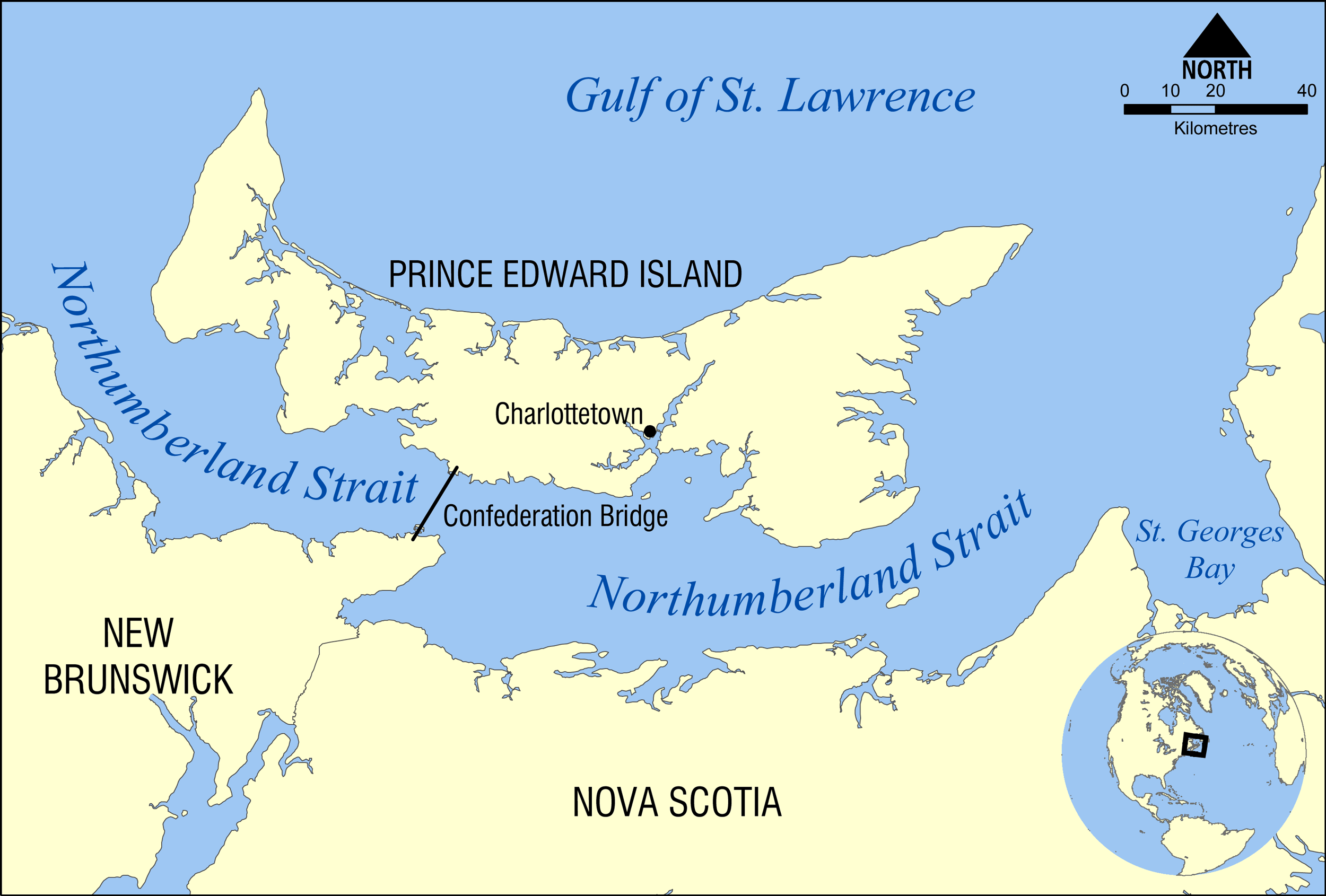
Prince Edward Island (PEI; ) is one of the thirteen Provinces and territories of Canada, provinces and territories of Canada. It is the smallest province in terms of land area and population, but the most densely populated. The island has several nicknames: "Garden of the Gulf", "Birthplace of Confederation" and "Cradle of Confederation". Its capital and largest city is Charlottetown. It is one of the three Maritime provinces and one of the four Atlantic provinces. Part of the traditional lands of the Miꞌkmaq, it was colonized by the French in 1604 as part of the colony of Acadia. The island was ceded to the British at the conclusion of the French and Indian War in 1763 and became part of the colony of Nova Scotia, and in 1769 the island became its own British colony. Prince Edward Island hosted the Charlottetown Conference in 1864 to discuss a Maritime Union, union of the Maritime provinces; however, the conference became the first in a series of meetings which led to Canadi ... [...More Info...] [...Related Items...] OR: [Wikipedia] [Google] [Baidu] |
Lot 47, Prince Edward Island
Lot 47 is a township in Kings County, Prince Edward Island, Canada Canada is a country in North America. Its ten provinces and three territories extend from the Atlantic Ocean to the Pacific Ocean and northward into the Arctic Ocean, covering over , making it the world's second-largest country by tot .... It is part of East Parish. Lot 47 was awarded to Gordon Graham and Robert Porter in the 1767 land lottery. References 47 Geography of Kings County, Prince Edward Island {{PrinceEdwardIsland-geo-stub ... [...More Info...] [...Related Items...] OR: [Wikipedia] [Google] [Baidu] |
Kings County, Prince Edward Island
Kings County (2021 population 18,327) is located in eastern Prince Edward Island, Canada. It is the province's smallest, most rural and least-populated county. Kings County is also least dependent upon the agriculture industry compared with the other two counties, while being more heavily dependent on the fishery and forest industry. Comparatively large parts of the county are still forested and it hosts the province's largest sawmill. The only heavy industry, aside from forestry and industrial farming, is a small shipyard, although secondary manufacturing has been established in recent years. The county was named by Capt. Samuel Holland in 1765 for King George III (1738–1820). As such, Kings County's shire town is Georgetown. The largest community within the town of Three Rivers. Demographics As a census division in the 2021 Census of Population conducted by Statistics Canada, Kings County had a population of living in of its total private dwellings, a change of ... [...More Info...] [...Related Items...] OR: [Wikipedia] [Google] [Baidu] |
Northumberland Strait
The Northumberland Strait (French: ''détroit de Northumberland'') is a strait in the southern part of the Gulf of Saint Lawrence in eastern Canada. The strait is formed by Prince Edward Island and the gulf's eastern, southern, and western shores. Boundaries The western boundary of the strait is delineated by a line running between North Cape, Prince Edward Island and Point Escuminac, New Brunswick while the eastern boundary is delineated by a line running between East Point, Prince Edward Island and Inverness, Nova Scotia. Hydrography The Northumberland Strait varies in depth between 17 and 65 metres, with the deepest waters at either end. The tidal patterns are complex; the eastern end has the usual two tides per day, with a tidal range of 1.2 to 1.8 metres, while the western end effectively has only one tide per day. The strait's shallow depths lend to warm water temperatures in summer months, with some areas reaching 25° C, or 77° F. Consequently, the strait is repo ... [...More Info...] [...Related Items...] OR: [Wikipedia] [Google] [Baidu] |
Basin Head Provincial Park
Basin Head Provincial Park is a provincial park located in Basin Head, Prince Edward Island, Canada. It is best known by its nickname "Singing Sands", in reference to the pure white sand that "sings" when stepped on, due to a high silica content. This sand is geologically unique to the area. Basin Head Provincial Park features a fisheries museum, souvenir shops, and interpretive center. The beach itself is split into two sections, divided by a channel (known locally as the 'run'). A bridge spans the 'run', and is a popular attraction for jumping and diving. It is open as a tourist attraction, operated by Tourism PEI, during the summer months. History Basin Head, located 13 kilometres east of Souris (the closest town), received its name from its wide, hollow bowl shaped form, like a basin. For many years it was a productive fishing area, with many local fisherman making their living fishing off shore. In 1937, it was decided to build a harbour and maintain a wharf at Basin Head ... [...More Info...] [...Related Items...] OR: [Wikipedia] [Google] [Baidu] |
Seven Wonders Of Canada
The Seven Wonders of Canada was a 2007 competition sponsored by CBC Television's '' The National'' and CBC Radio One's ''Sounds Like Canada''. They sought to determine Canada's "seven wonders" by receiving nominations from viewers, and then from on-line voting of the short list. After the vote, a panel of judges, Ra McGuire, Roy MacGregor and Roberta L. Jamieson, picked the winners based on geographic and poetic criteria. Their seven picks were revealed on '' The National'' on June 7, 2007. The Seven Wonders as chosen by Canada were the Sleeping Giant, Niagara Falls, the Bay of Fundy, Nahanni National Park Reserve, the Northern Lights, the Rockies, and the Cabot Trail. CBC's Seven Wonders of Canada Top seven as voted by Canada Full voting results Short list See also * Wonders of the World (other) * Wonders of the World Various lists of the Wonders of the World have been compiled from antiquity to the present day, in order to catalogue the world's most spectacu ... [...More Info...] [...Related Items...] OR: [Wikipedia] [Google] [Baidu] |
Headlands Of Prince Edward Island
A headland, also known as a head, is a coastal landform, a point of land usually high and often with a sheer drop, that extends into a body of water. It is a type of promontory. A headland of considerable size often is called a cape.Whittow, John (1984). ''Dictionary of Physical Geography''. London: Penguin, 1984, pp. 80, 246. . Headlands are characterised by high, breaking waves, rocky shores, intense erosion, and steep sea cliff. Headlands and bays are often found on the same coastline. A bay is flanked by land on three sides, whereas a headland is flanked by water on three sides. Headlands and bays form on discordant coastlines, where bands of rock of alternating resistance run perpendicular to the coast. Bays form when weak (less resistant) rocks (such as sands and clays) are eroded, leaving bands of stronger (more resistant) rocks (such as chalk, limestone, and granite) forming a headland, or peninsula. Through the deposition of sediment within the bay and the erosion of ... [...More Info...] [...Related Items...] OR: [Wikipedia] [Google] [Baidu] |


