|
Barra Head Lighthouse
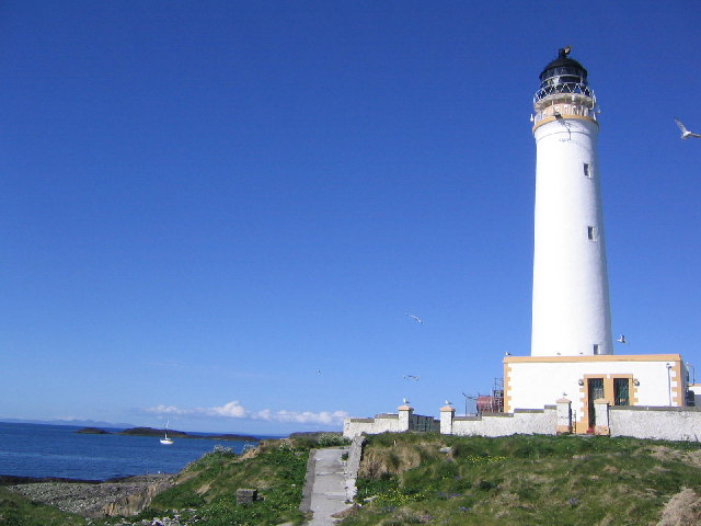
Barra Head Lighthouse on Barra Head identifies the southern entrance to The Minch, roughly halfway between the Eilean Glas and Rinns of Islay lighthouses. The stone tower, built in 1833, stands on the west side of the island, at the top of a very steep cliff, making the light the highest in the UK with a focal plane of above sea level. It has a range of . There is no shallow water west of Berneray to break the blow of the Atlantic storms and small fish are sometimes thrown onto the grass on the cliff top. In 1836 Sir Archibald Geikie recorded the movement of a block of gneiss across of ground during a violent storm.Haswell-Smith (2004) pp. 207–209. History Designed by Robert Stevenson and built by James Smith of Inverness the light was first exhibited on 15 October 1833. The oil-burning light was converted to incandescent in 1906 and the lighthouse was converted to automatic operation on 23 October 1980, when the last keepers were withdrawn. The main optic is now a ... [...More Info...] [...Related Items...] OR: [Wikipedia] [Google] [Baidu] |
Barra Head
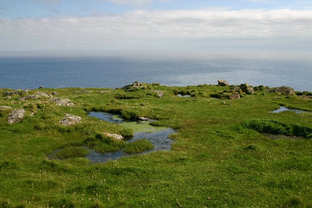
Barra Head, also known as Berneray ( gd, Beàrnaraigh; sco, Barra Heid), is the southernmost island of the Outer Hebrides in Scotland. Within the Outer Hebrides, it forms part of the Barra Isles archipelago. Originally, Barra Head only referred to the southernmost headland of Berneray but is now a common name for the entire island. The highest point of the island is Sotan, a Marilyn. There are numerous prehistoric structures on the island and permanent occupation by 20–50 individuals occurred throughout the historic period, peaking in the 19th century. The economy of the residents was based on agriculture, fishing and fowling. The cliffs provide nesting sites for seabirds in such profusion that Berneray has been designated as a Special Protection Area. The Barra Head Lighthouse, designed by Robert Stevenson, has operated since 1833. From 1931 to 1980 Barra Head was inhabited only by the lighthouse keepers and their wives but the lighthouse is now automated and t ... [...More Info...] [...Related Items...] OR: [Wikipedia] [Google] [Baidu] |
Hyskeir
Hyskeir ( gd, Òigh-sgeir) or Heyskeir is a low-lying rocky islet (a skerry) in the Inner Hebrides, Scotland. The Hyskeir Lighthouse marks the southern entrance to the Minch. Geography Hyskeir lies in the southern entrance to the Minch, 10 kilometres southwest of the island of Canna and 14 kilometres west of Rùm. Garbh Sgeir is a rock that lies next to the islet and the landing place for Hyskeir lies in the channel between the two. Both islands are unoccupied. Òigh-sgeir is composed of hexagonal pitchstone columns. The owner of the island in the 19th and early 20th centuries was Philip Ollas. At that time sheep from Canna were brought to make use of the summer grazing. Etymology Hyskeir is from the Old Norse ''sker'' meaning skerry. ''Òigh-sgeir'' is Gaelic for 'maiden' or 'virgin rock', ''sgeir'' also meaning skerry. The English name 'Maiden Rock' has also been used. Lighthouse Hyskeir Lighthouse was established in 1904. The building marks the southern end of the M ... [...More Info...] [...Related Items...] OR: [Wikipedia] [Google] [Baidu] |
Lighthouses In Outer Hebrides
A lighthouse is a tower, building, or other type of physical structure designed to emit light from a system of lamps and lenses and to serve as a beacon for navigational aid, for maritime pilots at sea or on inland waterways. Lighthouses mark dangerous coastlines, hazardous shoals, reefs, rocks, and safe entries to harbors; they also assist in aerial navigation. Once widely used, the number of operational lighthouses has declined due to the expense of maintenance and has become uneconomical since the advent of much cheaper, more sophisticated and effective electronic navigational systems. History Ancient lighthouses Before the development of clearly defined ports, mariners were guided by fires built on hilltops. Since elevating the fire would improve the visibility, placing the fire on a platform became a practice that led to the development of the lighthouse. In antiquity, the lighthouse functioned more as an entrance marker to ports than as a warning signal for reefs and ... [...More Info...] [...Related Items...] OR: [Wikipedia] [Google] [Baidu] |
Lighthouses Completed In 1833
A lighthouse is a tower, building, or other type of physical structure designed to emit light from a system of lamps and lenses and to serve as a beacon for navigational aid, for maritime pilots at sea or on inland waterways. Lighthouses mark dangerous coastlines, hazardous shoals, reefs, rocks, and safe entries to harbors; they also assist in aerial navigation. Once widely used, the number of operational lighthouses has declined due to the expense of maintenance and has become uneconomical since the advent of much cheaper, more sophisticated and effective electronic navigational systems. History Ancient lighthouses Before the development of clearly defined ports, mariners were guided by fires built on hilltops. Since elevating the fire would improve the visibility, placing the fire on a platform became a practice that led to the development of the lighthouse. In antiquity, the lighthouse functioned more as an entrance marker to ports than as a warning signal for reefs and ... [...More Info...] [...Related Items...] OR: [Wikipedia] [Google] [Baidu] |
List Of Category A Listed Buildings In The Western Isles
This is a list of Category A listed buildings in the Western Isles of Scotland ( gd, Na h-Eileanan Siar). In Scotland, the term listed building refers to a building or other structure officially designated as being of "special architectural or historic interest". Category A structures are those considered to be "buildings of national or international importance, either architectural or historic, or fine little-altered examples of some particular period, style or building type." Listing was begun by a provision in the Town and Country Planning (Scotland) Act 1947, and the current legislative basis for listing is the Planning (Listed Buildings and Conservation Areas) (Scotland) Act 1997. The authority for listing rests with Historic Scotland, an executive agency of the Scottish Government, which inherited this role from the Scottish Development Department in 1991. Once listed, severe restrictions are imposed on the modifications allowed to a building's structure or its fitting ... [...More Info...] [...Related Items...] OR: [Wikipedia] [Google] [Baidu] |
List Of Northern Lighthouse Board Lighthouses
This is a list of the currently operational lighthouses of the Northern Lighthouse Board (NLB). The list is divided by geographical location, and then by whether the lighthouses are classed by the NLB as a 'major lighthouse' or a 'minor light'. Former NLB lighthouses now disposed of are not included in the list. Scotland (except principal island groups) Major lighthouses Minor lights * Ardtornish * Bass Rock * Cailleach Head * Cairnbulg Briggs * Corran Narrows North East * Corran Point * Craigton Point * Dunollie * Elie Ness * Hestan Island * Holy Island (Inner) * Lady Isle * Little Ross * Little Ross Beacon * Loch Eriboll * Loch Ryan * Longman Point * Oban NLB Pier * Sandaig * Sgeir Bhuidhe * Sula Sgeir * Turnberry The Hebrides Major lighthouses * Barra Head * Butt of Lewis * Dubh Artach * Eilean Glas * Flannan Islands * * Hyskeir * Lismore * Monach * Neist Point * * Rinns of Islay * * Ruvaal * Scarinish * Skerryvore * Tiumpan Head * Ushenish Minor ligh ... [...More Info...] [...Related Items...] OR: [Wikipedia] [Google] [Baidu] |
List Of Lighthouses In Scotland
This is a list of lighthouses in Scotland. The Northern Lighthouse Board, from which much of the information is derived, are responsible for most lighthouses in Scotland but have handed over responsibility in the major estuaries to the port authorities. Many of the more minor lights are not shown. A lighthouse that is no longer operating is indicated by the date of closure in the ''operated by'' column. Where two dates are shown, the lighthouse has been rebuilt. Nearly all the lighthouses in this list were designed by and most were built by four generations of one family, including Thomas Smith, who was both the stepfather and father-in-law of Robert Stevenson. Robert's sons and grandsons not only built most of the lights, often under the most appalling of conditions, but pioneered many of the improvements in lighting and signalling that cut down the enormous loss of life in shipping around the coasts of Scotland. The table may be sorted by any column by clicking on the headin ... [...More Info...] [...Related Items...] OR: [Wikipedia] [Google] [Baidu] |
World War II
World War II or the Second World War, often abbreviated as WWII or WW2, was a world war that lasted from 1939 to 1945. It involved the vast majority of the world's countries—including all of the great powers—forming two opposing military alliances: the Allies and the Axis powers. World War II was a total war that directly involved more than 100 million personnel from more than 30 countries. The major participants in the war threw their entire economic, industrial, and scientific capabilities behind the war effort, blurring the distinction between civilian and military resources. Aircraft played a major role in the conflict, enabling the strategic bombing of population centres and deploying the only two nuclear weapons ever used in war. World War II was by far the deadliest conflict in human history; it resulted in 70 to 85 million fatalities, mostly among civilians. Tens of millions died due to genocides (including the Holocaust), starvation, ma ... [...More Info...] [...Related Items...] OR: [Wikipedia] [Google] [Baidu] |
Bristol Blenheim
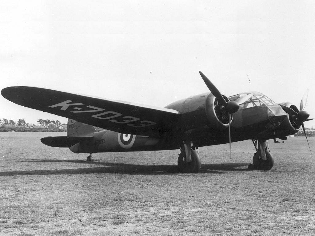
The Bristol Blenheim is a British light bomber aircraft designed and built by the Bristol Aeroplane Company (Bristol) which was used extensively in the first two years of the Second World War, with examples still being used as trainers until the end of the war. Development began with the ''Type 142'', a civil airliner, in response to a challenge from Lord Rothermere to produce the fastest commercial aircraft in Europe. The ''Type 142'' first flew in April 1935, and the Air Ministry, impressed by its performance, ordered a modified design as the ''Type 142M'' for the Royal Air Force (RAF) as a bomber. Deliveries of the newly named Blenheim to RAF squadrons commenced on 10 March 1937. In service the Type 142M became the Blenheim Mk.I which would be developed into the longer Type 149, designated the Blenheim Mk.IV, except in Canada where Fairchild Canada built the Type 149 under licence as the Bolingbroke. The Type 160 Bisley was also developed from the Blenheim, but was already o ... [...More Info...] [...Related Items...] OR: [Wikipedia] [Google] [Baidu] |
Barra Head Cemetery
Barra (; gd, Barraigh or ; sco, Barra) is an island in the Outer Hebrides, Scotland, and the second southernmost inhabited island there, after the adjacent island of Vatersay to which it is connected by a short causeway. The island is named after Saint Finbarr of Cork. In 2011, the population was 1,174. Gaelic is widely spoken, and at the 2011 Census, there were 761 Gaelic speakers (62% of the population). Geology In common with the rest of the Western Isles, Barra is formed from the oldest rocks in Britain, the Lewisian gneiss, which dates from the Archaean eon. Some of the gneiss in the east of the island is noted as being pyroxene-bearing. Layered textures or foliation in this metamorphic rock is typically around 30° to the east or northeast. Palaeoproterozoic age metadiorites and metatonalites forming a part of the East Barra Meta-igneous Complex occur around Castlebay as they do on the neighbouring islands of Vatersay and Flodday. A few metabasic dykes intru ... [...More Info...] [...Related Items...] OR: [Wikipedia] [Google] [Baidu] |
Croft (land)
A croft is a fenced or enclosed area of land, usually small and arable, and usually, but not always, with a crofter's dwelling thereon. A crofter is one who has tenure and use of the land, typically as a tenant farmer, especially in rural areas. Etymology The word ''croft'' is West Germanic in etymology and is now most familiar in Scotland, most crofts being in the Highlands and Islands area. Elsewhere the expression is generally archaic. In Scottish Gaelic, it is rendered (, plural ). Legislation in Scotland The Scottish croft is a small agricultural landholding of a type that has been subject to special legislation applying to the Scottish Highlands since 1886. The legislation was largely a response to the complaints and demands of tenant families who were victims of the Highland Clearances. The modern crofters or tenants appear very little in evidence before the beginning of the 18th century. They were tenants at will underneath the tacksman and wadsetters, but practi ... [...More Info...] [...Related Items...] OR: [Wikipedia] [Google] [Baidu] |
RNLI
The Royal National Lifeboat Institution (RNLI) is the largest charity that saves lives at sea around the coasts of the United Kingdom, the Republic of Ireland, the Channel Islands, and the Isle of Man, as well as on some inland waterways. It is one of several lifeboat services operating in the same area. Founded in 1824 as the National Institution for the Preservation of Life from Shipwreck, soon afterwards becoming the Royal National Institution for the Preservation of Life from Shipwreck, under the patronage of King George IV. On 5 October 1854, the institution’s name was changed to its current name (RNLI), and in 1860 was granted a royal charter. The RNLI is a charity in the UK and in the Republic of Ireland and has enjoyed royal patronage since its foundation, the most recent being Queen Elizabeth II until her death on 8 September 2022. The RNLI is principally funded by legacies (65%) and donations (28%), with the remainder from merchandising and investment. Most of th ... [...More Info...] [...Related Items...] OR: [Wikipedia] [Google] [Baidu] |


