|
Banihal
Banihal () is a town and a notified area committee, near Ramban town in Ramban district in the Indian union territory of Jammu and Kashmir. It is a rural and hilly area with Kamirwah being one of the most prominent hills. It is located about away from Qazigund of Anantnag district on NH 44 (former name NH 1A before renumbering of all national highways). However, the distance between Banihal and Qazigund is only 18 km by train on the new railway line which is much shorter than the road. The most common language spoken in the region is Kashmiri; Urdu, Hindi, Gujjari, Pahari and English being other familiar languages. Banihal forms the main gateway to the valley of Kashmir. Etymology "Banihal" means blizzard in the Kashmiri language. Another view regarding the origin of the name of the place is that the word 'Banihal' has actually been derived from two Kashmiri words viz 'bah' meaning twelve and 'nallhe' meaning a rivulet. Twelve rivulets signifying the various brooks flowing ... [...More Info...] [...Related Items...] OR: [Wikipedia] [Google] [Baidu] |
Pir Panjal
The Pir Panjal Range (Kashmiri: ) is a group of mountains in the Lesser Himalayan region, running from east-southeast (ESE) to west-northwest (WNW) across the Indian territories of Himachal Pradesh and Jammu and Kashmir and then Pakistan's Azad Kashmir and Punjab. The average elevation varies from to . The Himalayas show a gradual elevation towards the Dhauladhar and Pir Panjal ranges. Pir Panjal is the largest range of the Lesser Himalayas. Near the bank of the Sutlej River, it dissociates itself from the Himalayas and forms a divide between the Beas and Ravi rivers on one side and the Chenab on the other. The renowned Galyat mountains are also located in this range. Etymology The Pir Panjal range is named after the Pir Panjal Pass, whose original name as recorded by Srivara, is ''Panchaladeva'' (IAST: ''Pāñcāladeva'', meaning the deity of ''Panchala''). Panchala is a country mentioned in the Mahabharata in the northwest Uttar Pradesh. However, there are also traditi ... [...More Info...] [...Related Items...] OR: [Wikipedia] [Google] [Baidu] |
Ramban, Jammu And Kashmir
Ramban is a town in Ramban district of Jammu and Kashmir, India, which is the district headquarters of Ramban district. It lies on the banks of the Chenab river in Chenab Valley on the National Highway-1A (now NH-44) at about 120 km from Jammu and about 130 km from Srinagar, making it almost the central point on the Jammu-Srinagar National Highway. Mosques in Ramban Jamma Masjid is located in Masjid Market Ramban Just Near newly Constructed Flyover Cafeteria Masjid and Jadeed Jamma Masjid Near Higher Secondary school Ramban Other near Mosques are Chandroog Jamma Masjid SALAFIA Masjid Maitra Village in Ramban District Naik Mohalla Maitra, Ramban Jatgali, Ramban Rajgarh, Ramban Chanderkote, Ramban (Tanveer Mir Village) History C.E. Bats writes in his book, ‘''The Gazetteer of Kashmir''’, that before the formation of the J&K State in 1846, there was a small village consisting of 15 houses on the right bank of Chenab river known as Nashband (later ' ... [...More Info...] [...Related Items...] OR: [Wikipedia] [Google] [Baidu] |
Ramban District
Ramban district is a district in the Indian union territory of Jammu and Kashmir, located in the lap of the Pir Panjal range. It was carved out as a separate district from erstwhile Doda district in 2007. It is located in the Jammu division. The district headquarters are at Ramban town, which is located midway between Jammu and Srinagar along the Chenab river in the Chenab valley on National Highway-44, approximately 151 km from Jammu and Srinagar. Administration Ramban District is divided into eight tehsils: Banihal, Ramban, Khari, Rajgarh, Batote, Gool, Pogal Paristan (Ukhral) and Ramsoo. Each tehsil has its tehsildar, who is the administrative head. The district consisted of 116 census villages and 127 revenue villages in 2001. The total number of panchayat Halqas in the district was 124. District Development Council Ramban In the elections for Ramban's District Development Council, Shamshad Begum was elected chairman and Rabiya Beigh was elected vice-chairman. G ... [...More Info...] [...Related Items...] OR: [Wikipedia] [Google] [Baidu] |
Srinagar
Srinagar (English: , ) is the largest city and the summer capital of Jammu and Kashmir, India. It lies in the Kashmir Valley on the banks of the Jhelum River, a tributary of the Indus, and Dal and Anchar lakes. The city is known for its natural environment, gardens, waterfronts and houseboats. It is known for traditional Kashmiri handicrafts like the Kashmir shawl (made of pashmina and cashmere wool), and also dried fruits. It is the 31st-most populous city in India, the northernmost city in India to have over one million people, and the second-largest metropolitan area in the Himalayas (after Kathmandu, Nepal). Origin of name The earliest records, such as Kalhana's ''Rajatarangini'', mentions the Sanskrit name ''shri-nagara'' which have been interpreted distinctively by scholars in two ways: one being ''sūrya-nagar'', meaning "''City of the Surya''" (trans) ''"City of Sun''" and other being ''"The city of "Shri''" (श्री), the Hindu goddess of wealth, meaning "' ... [...More Info...] [...Related Items...] OR: [Wikipedia] [Google] [Baidu] |
National Highway 1A (India, Old Numbering)
National Highway 1A (NH 1A) was a National Highway in North India that connected the Kashmir valley to Jammu and the rest of India. The northern terminal was in Uri in Jammu and Kashmir and the southern terminal was in Jalandhar. Stretches of old NH 1A ran through some extremely treacherous terrain and shut-offs because of avalanches or landslides common in Winter months. The famous Jawahar Tunnel that connects Jammu with the Kashmir Valley across the Pir Panjal Range falls en route. The total length of NH 1A was 663 km. New tunnels on the road were planned to reduce the distance between the two cities by 82 km and the travel time by two-thirds. Most of these tunnels such as Dr. Syama Prasad Mookerjee Tunnel and new Banihal double_road_tunnel have been executed and commissioned. Renumbering NH 1A number now does not exist and old NH 1A is now a part of new NH 1 and NH 44 after renumbering of all national highways in the year 2010. National Highways Developm ... [...More Info...] [...Related Items...] OR: [Wikipedia] [Google] [Baidu] |
Qazigund
Qazigund, also known as Gateway Of Kashmir, is a town and in the union territory of Jammu and Kashmir, India. Qazigund is located at . It has an average elevation of 1670 m (5478 feet) above mean sea level. Qazigund Bypass Passes Through ''Dalwatch, Chimulla & Shampora'' Villages of Qazigund. Qazigund Is Connected by NH44 & Northern Railways with Rest of The Country. Qazigund Toll Plaza Is one of the Beautiful Toll Plaza Among Rest of the Toll plazas. Demographics As of 2011 India census, Qazigund had a population of 9871. Males constitute 55% of the population and females 45%. Qazigund has an average literacy rate of 70.21%, higher than the national average of 67.16%, male literacy is 79.82%, and female literacy is 58.27%. In Qazigund, 20.67% of the population is under 6 years of age. Qazigund Byepass Is Via Dalwach, Chimulla & Shampora Villages. Qazigund is surrounded by springs, known as ''nags'' in the local language. Verinag source of river Jhelum is onl ... [...More Info...] [...Related Items...] OR: [Wikipedia] [Google] [Baidu] |
Jammu And Kashmir (union Territory)
Jammu and Kashmir is a region administered by India as a union territory and consists of the southern portion of the larger Kashmir region, which has been the subject of a dispute between India and Pakistan since 1947, and between India and China since 1962.(a) (subscription required) Quote: "Kashmir, region of the northwestern Indian subcontinent ... has been the subject of dispute between India and Pakistan since the partition of the Indian subcontinent in 1947. The northern and western portions are administered by Pakistan and comprise three areas: Azad Kashmir, Gilgit, and Baltistan, the last two being part of a territory called the Northern Areas. Administered by India are the southern and southeastern portions, which constitute the state of Jammu and Kashmir but are slated to be split into two union territories. China became active in the eastern area of Kashmir in the 1950s and has controlled the northeastern part of Ladakh (the easternmost portion of the region) sinc ... [...More Info...] [...Related Items...] OR: [Wikipedia] [Google] [Baidu] |
Muzaffarabad
Muzaffarabad (; ur, ) is the capital and largest city of Azad Kashmir, and the 60th largest in Pakistan. The city is located in Muzaffarabad District, near the confluence of the Jhelum and Neelum rivers. The district is bounded by the Pakistani province of Khyber Pakhtunkhwa in the west, the Kupwara and Baramulla districts of Indian-administered Jammu and Kashmir in the east, and the Neelum District in the north. History Muzaffarabad was founded in 1646 by Sultan Muzaffar Khan, chief of the Bomba tribe who ruled Kashmir. Khan also constructed the Red Fort that same year for the purpose of warding off incursions from the Mughal Empire. 2005 earthquake The city was near the epicenter of the 2005 Kashmir earthquake, which had a magnitude of 7.6 Mw. The earthquake destroyed about 50% of the buildings in the city (including most government buildings) and is estimated to have killed up to 80,000 people in the Pakistani-controlled areas. , the Pakistani government's offi ... [...More Info...] [...Related Items...] OR: [Wikipedia] [Google] [Baidu] |
Murree
Murree ( Punjabi, Urdu: مری) is a mountain resort city, located in the Galyat region of the Pir Panjal Range, within the Muree District of Punjab, Pakistan. It forms the outskirts of the Islamabad-Rawalpindi metropolitan area, and is about northeast of Islamabad. It has average altitude of . The British built this town during their rule to escape the scorching heat in the plains of Punjab during the summer. Construction of the town was started in 1851 on the hill of Murree as a sanatorium for British troops. The permanent town of Murree was constructed in 1853 and the church was consecrated shortly thereafter. One main road was established, commonly referred to even in modern times, as the mall. Murree was the summer headquarters of the colonial Punjab Government until 1876 when it was moved to Shimla. Murree became a popular tourist station for British citizens of the British Raj. Several prominent Britons were born here including Bruce Bairnsfather, Francis Younghusband, ... [...More Info...] [...Related Items...] OR: [Wikipedia] [Google] [Baidu] |
Top View Of Highway Banihal By Mutahir Showkat
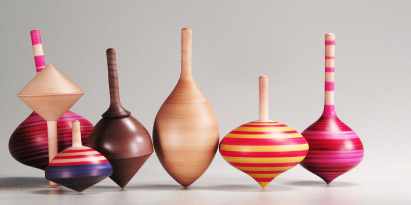
A spinning top, or simply a top, is a toy with a squat body and a sharp point at the bottom, designed to be spun on its vertical axis, balancing on the tip due to the gyroscopic effect. Once set in motion, a top will usually wobble for a few seconds, spin upright for a while, then start to wobble again with increasing amplitude as it loses energy, and finally tip over and roll on its side. Tops exist in many variations and materials, chiefly wood, metal, and plastic, often with a metal tip. They may be set in motion by twirling a handle with the fingers, by pulling a rope coiled around the body, or by means of a built-in auger (spiral plunger). Such toys have been used since antiquity in solitary or competitive games, where each player tries to keep one's top spinning for as long as possible, or achieve some other goal. Some tops have faceted bodies with symbols or inscriptions, and are used like dice to inject randomness into games, or for divination and ritual purposes. ... [...More Info...] [...Related Items...] OR: [Wikipedia] [Google] [Baidu] |
Persian Language
Persian (), also known by its endonym Farsi (, ', ), is a Western Iranian language belonging to the Iranian branch of the Indo-Iranian subdivision of the Indo-European languages. Persian is a pluricentric language predominantly spoken and used officially within Iran, Afghanistan, and Tajikistan in three mutually intelligible standard varieties, namely Iranian Persian (officially known as ''Persian''), Dari Persian (officially known as ''Dari'' since 1964) and Tajiki Persian (officially known as ''Tajik'' since 1999).Siddikzoda, S. "Tajik Language: Farsi or not Farsi?" in ''Media Insight Central Asia #27'', August 2002. It is also spoken natively in the Tajik variety by a significant population within Uzbekistan, as well as within other regions with a Persianate history in the cultural sphere of Greater Iran. It is written officially within Iran and Afghanistan in the Persian alphabet, a derivation of the Arabic script, and within Tajikistan in the Tajik alphabet, a der ... [...More Info...] [...Related Items...] OR: [Wikipedia] [Google] [Baidu] |


