|
Bani, Bani
Bani is the capital of Bani Department in Séno Province in northern Burkina Faso. It had a population of 5 771 in 2008. Bani is known for its seven mosques made of clay and is situated between Kaya, Burkina Faso and Dori, Burkina Faso Dori (also known as Winde or Wendu) is a town in northeastern Burkina Faso, near the border of Niger. It is located at around . It is the capital of Sahel Region and has a population of 46,512 (2019). The main ethnic group is the Fula (Fulani) bu .... Gallery ASC Leiden - F. van der Kraaij Collection - 07 - 070 - La Grande Mosquée de Bani avec un minaret rond. Une autre mosquée - Bani, Séno, Sahel, Burkina Faso, 1983.tif, A boy in front of three mosques of Bani in the distance, 1983 File:Bani1-torre.jpg, Minaret with protruding horizontal wooden sticks of the mosque of Bani, Burkina Faso, 2007 File:Village Elder - Bani - Sahel Region - Burkina Faso.jpg, Village elder of Bani, 2010 File:Mud Mosque - Bani - Sahel Region - Burkina Faso - ... [...More Info...] [...Related Items...] OR: [Wikipedia] [Google] [Baidu] |
Regions Of Burkina Faso
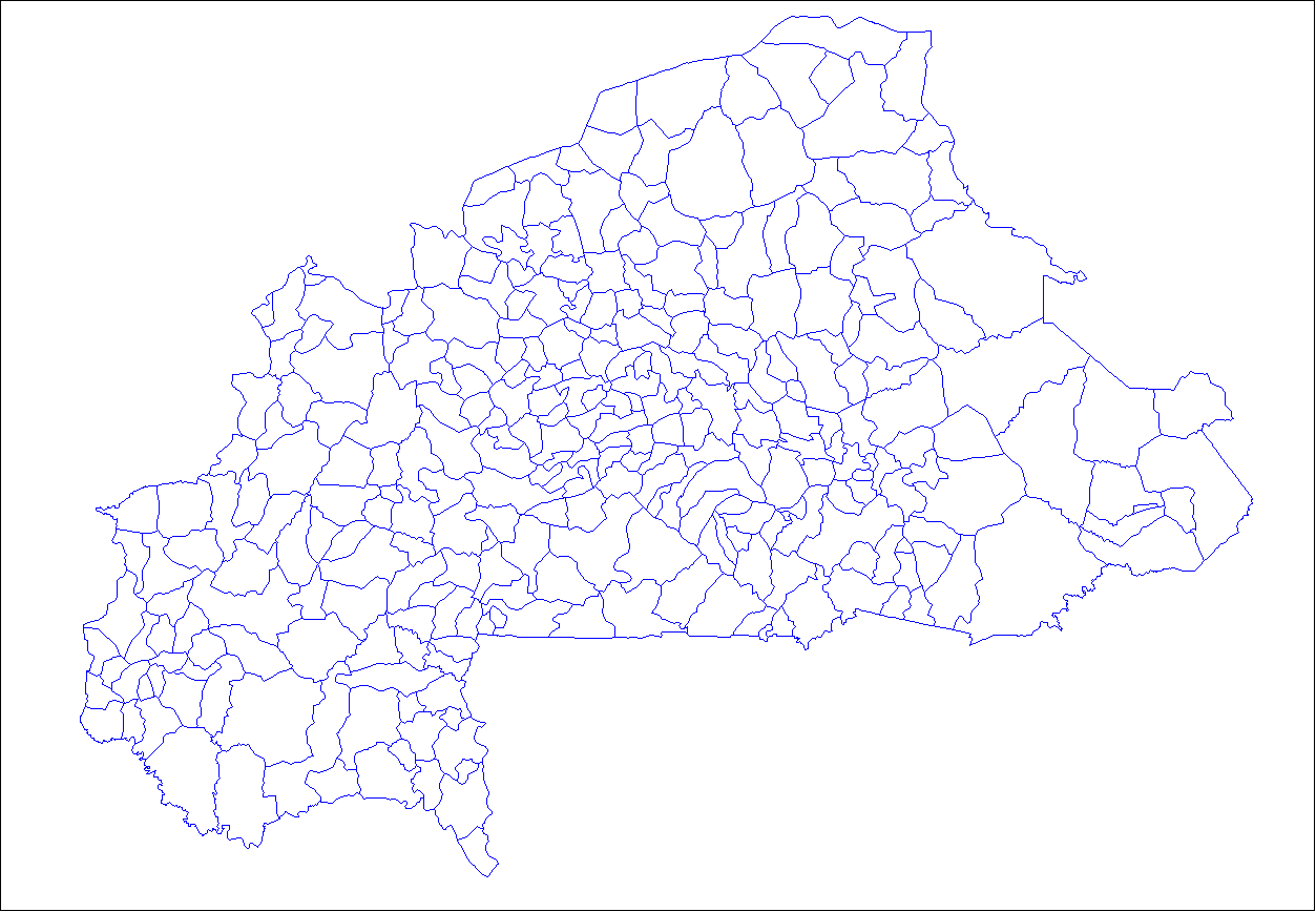
Per Law No.40/98/AN in 1998, Burkina Faso adhered to decentralization to provide administrative and financial autonomy to local communities. Most of these, according to their individual articles, were implemented on 2 July 2001. Burkina Faso is divided into 13 administrative regions. Each region is administered by a governor. These regions are divided into 45 provinces and subdivided into 351 communes. See also *List of regions of Burkina Faso by Human Development Index *Provinces of Burkina Faso *Departments of Burkina Faso, Departments/Communes of Burkina Faso *Geography of Burkina Faso *ISO 3166-2:BF References See also Regions of Burkina Faso at Statoids.com {{Burkina Faso topics Regions of Burkina Faso, Subdivisions of Burkina Faso Lists of administrative divisions, Burkina Faso, Regions Administrative divisions in Africa, Burkina Faso 1 First-level administrative divisions by country, Regions, Burkina Faso Burkina Faso geography-related lists ... [...More Info...] [...Related Items...] OR: [Wikipedia] [Google] [Baidu] |
Sahel Region
Sahel is one of Burkina Faso's 13 administrative regions. It was created on 2 July 2001. The region's capital is Dori. Four provinces make up the region—Oudalan, Séno, Soum, and Yagha. As of 2019, the population of the region was 1,094,907 with 49.3% females. The population in the region was 5.34% of the total population of the country. The child mortality rate was 132, infant mortality rate was 119 and the mortality of children under five was 235. The coverage of cereal need compared to the total production of the region was 81%. As of 2007, the literacy rate in the region was 18%, compared to a national average of 28.3%. Geography Most of Burkina Faso is a wide plateau formed by riverine systems and is called Falaise de Banfora. There are three major rivers, the Red Volta, Black Volta and White Volta, which cuts through different valleys. The climate is generally hot, with unreliable rains across different seasons. Gold and quartz are common minerals found across the c ... [...More Info...] [...Related Items...] OR: [Wikipedia] [Google] [Baidu] |
Provinces Of Burkina Faso
The regions of Burkina Faso are divided into 45 administrative provinces. These 45 provinces are currently sub-divided into 351 departments or communes. List of provinces by region Here is a list of the provinces, with their capitals in parentheses: Central Burkina Faso Centre Region * Kadiogo (Ouagadougou) (#14 in map) Centre-Nord Region * Bam (Kongoussi) (#2 in map) * Namentenga (Boulsa) (#26 in map) * Sanmatenga (Kaya) (#34 in map) Centre-Sud Region * Bazèga (Kombissiri) (#4 in map) * Nahouri ( Pô) (#25 in map) * Zoundwéogo (Manga) (#45 in map) Plateau-Central Region * Ganzourgou (Zorgho) (#9 in map) * Kourwéogo (Boussé) (#21 in map) * Oubritenga (Ziniaré) (#29 in map) Eastern Burkina Faso Centre-Est Region * Boulgou (Tenkodogo) (#6 in map) * Koulpélogo ( Ouargaye) (#19 in map) * Kouritenga ( Koupéla) (#20 in map) Est Region * Gnagna (Bogandé) (#10 in map) * Gourma (Fada N'gourma) (#11 in map) * Komondjari (Gayéri) (#16 in map) * Kompienga ( Pam ... [...More Info...] [...Related Items...] OR: [Wikipedia] [Google] [Baidu] |
Séno Province
Séno is one of the 45 provinces of Burkina Faso, located in its Sahel Region. The name of the province comes from the Fulfulde ''seeno'', for "sandy plain." Its capital is Dori. Departments Seno is divided into 6 departments: See also *Regions of Burkina Faso *Provinces of Burkina Faso *Departments of Burkina Faso The provinces of Burkina Faso are divided into 351 departments (as of 2014 and since local elections of 2012), whose urbanized areas (cities, towns and villages) are grouped into the same commune (municipality) with the same name as the department ... References Provinces of Burkina Faso {{Séno-geo-stub ... [...More Info...] [...Related Items...] OR: [Wikipedia] [Google] [Baidu] |
Departments Of Burkina Faso
The provinces of Burkina Faso are divided into 351 departments (as of 2014 and since local elections of 2012), whose urbanized areas (cities, towns and villages) are grouped into the same commune (municipality) with the same name as the department. The department also covers rural areas (including national natural parks) that are not governed locally by the elected municipal council of the commune (presided by its mayor, with representants elected for each village or urban sector), but by the state represented at departmental level by a prefect (supervized by the haut-commissaire of its province, themself assisted by a general secretary and acting under the hierarchic authority the governor of its region, all of them being nominated by the national government). Status of communes The 351 communes (municipalities) created for each one of these departments have three kinds of status : * 49 urban communes are grouping their main city/town (subdivided into urban sectors) and all ... [...More Info...] [...Related Items...] OR: [Wikipedia] [Google] [Baidu] |
Bani Department
Bani is a department of Séno Province in northern Burkina Faso. Its capital is the town of Bani Bani may refer to: Places Africa *Bani Department, a department in the Séno Province of Burkina Faso *Bani, Bani, Séno, Burkina Faso * Bani, Bourzanga, Bam, Burkina Faso *Bani, Gnagna, Burkina Faso * Bani, The Gambia *Bani River, a tributary ... which has a historic mosque and tower. Gallery File:Bani1-torre.jpg, Minaret with protruding horizontal wooden sticks of the mosque of Bani, Burkina Faso, 2007 File:Mud Mosque - Bani - Sahel Region - Burkina Faso - 02.jpg, Mud mosque of Bani, 2010 References Departments of Burkina Faso Séno Province {{Séno-geo-stub ... [...More Info...] [...Related Items...] OR: [Wikipedia] [Google] [Baidu] |
Burkina Faso
Burkina Faso (, ; , ff, 𞤄𞤵𞤪𞤳𞤭𞤲𞤢 𞤊𞤢𞤧𞤮, italic=no) is a landlocked country in West Africa with an area of , bordered by Mali to the northwest, Niger to the northeast, Benin to the southeast, Togo and Ghana to the south, and the Ivory Coast to the southwest. It has a population of 20,321,378. Previously called Republic of Upper Volta (1958–1984), it was renamed Burkina Faso by President Thomas Sankara. Its citizens are known as ''Burkinabè'' ( ), and its capital and largest city is Ouagadougou. The largest ethnic group in Burkina Faso is the Mossi people, who settled the area in the 11th and 13th centuries. They established powerful kingdoms such as the Ouagadougou, Tenkodogo, and Yatenga. In 1896, it was colonized by the French as part of French West Africa; in 1958, Upper Volta became a self-governing colony within the French Community. In 1960, it gained full independence with Maurice Yaméogo as president. Throughout the decades post in ... [...More Info...] [...Related Items...] OR: [Wikipedia] [Google] [Baidu] |
Kaya, Burkina Faso
Kaya is the fifth largest city in Burkina Faso, lying northeast of Ouagadougou, to which it is connected by railway. It is a centre for weaving and tanning. Kaya is the capital of Sanmatenga Province. It is located from Ouagadougou, the capital of Burkina Faso. Demographics Kaya has a population of 121,970 (2019 census). Population growth: Infrastructure Kaya Airport is a public airport in Kaya. As of 2014 it did not have any scheduled commercial flights. In 1988 Kaya was connected by railway to OuagadougouHistorical Dictionary of Burkina Faso, by Lawrence Rupley, Lamissa Bangali, Boureima Diamitani, 2013, third edition, Scarecrow Press, Inc. but, as of 2014, there were no passenger services available. Kaya is a road junction for the N3 and N15 national highways that link the city with Dori, Ouagadougou and Pouytenga, Boulsa, Kongoussi and Ouahigouya, respectively. Education *technical college for girls *secondary school Climate Köppen-Geiger climate classifi ... [...More Info...] [...Related Items...] OR: [Wikipedia] [Google] [Baidu] |
Dori, Burkina Faso
Dori (also known as Winde or Wendu) is a town in northeastern Burkina Faso, near the border of Niger. It is located at around . It is the capital of Sahel Region and has a population of 46,512 (2019). The main ethnic group is the Fula (Fulani) but Tuaregs, Songhai, and Hausa people are often present. It is a town known for its herders and popular livestock markets. Dori recorded a temperature of in 1984, which is the highest temperature to have ever been recorded in Burkina Faso. Mines In 2004, a proposal surfaced to link the manganese mines by rail with the seaports of Ghana. Notable people * Roukiatou Maiga, humanitarian * Albert Ouédraogo, former Burkinabé Prime Minister See also * Railway stations in Burkina Faso Gallery File:ASC Leiden - van Achterberg Collection - 5 - 050 - Le vieux quartier de Dori avec ses habitants - Dori, Séno, Burkina Faso, 19-26 août 2001.tif, The old district of Dori with its inhabitants, 2001 File:ASC Leiden - van Achterberg Collect ... [...More Info...] [...Related Items...] OR: [Wikipedia] [Google] [Baidu] |
Panorama Over Bani With Mosques - Bani - Sahel Region - Burkina Faso
A panorama (formed from Greek πᾶν "all" + ὅραμα "view") is any wide-angle view or representation of a physical space, whether in painting, drawing, photography, film, seismic images, or 3D modeling. The word was originally coined in the 18th century by the English (Irish descent) painter Robert Barker to describe his panoramic paintings of Edinburgh and London. The motion-picture term ''panning'' is derived from ''panorama''. A panoramic view is also purposed for multimedia, cross-scale applications to an outline overview (from a distance) along and across repositories. This so-called "cognitive panorama" is a panoramic view over, and a combination of, cognitive spaces used to capture the larger scale. History The device of the panorama existed in painting, particularly in murals, as early as 20 A.D., in those found in Pompeii, as a means of generating an immersive "panoptic" experience of a vista. Cartographic experiments during the Enlightenment era prece ... [...More Info...] [...Related Items...] OR: [Wikipedia] [Google] [Baidu] |
Populated Places In The Centre-Nord Region
Population typically refers to the number of people in a single area, whether it be a city or town, region, country, continent, or the world. Governments typically quantify the size of the resident population within their jurisdiction using a census, a process of collecting, analysing, compiling, and publishing data regarding a population. Perspectives of various disciplines Social sciences In sociology and population geography, population refers to a group of human beings with some predefined criterion in common, such as location, race, ethnicity, nationality, or religion. Demography is a social science which entails the statistical study of populations. Ecology In ecology, a population is a group of organisms of the same species who inhabit the same particular geographical area and are capable of interbreeding. The area of a sexual population is the area where inter-breeding is possible between any pair within the area and more probable than cross-breeding with ind ... [...More Info...] [...Related Items...] OR: [Wikipedia] [Google] [Baidu] |


