|
Bamfurlong, Greater Manchester
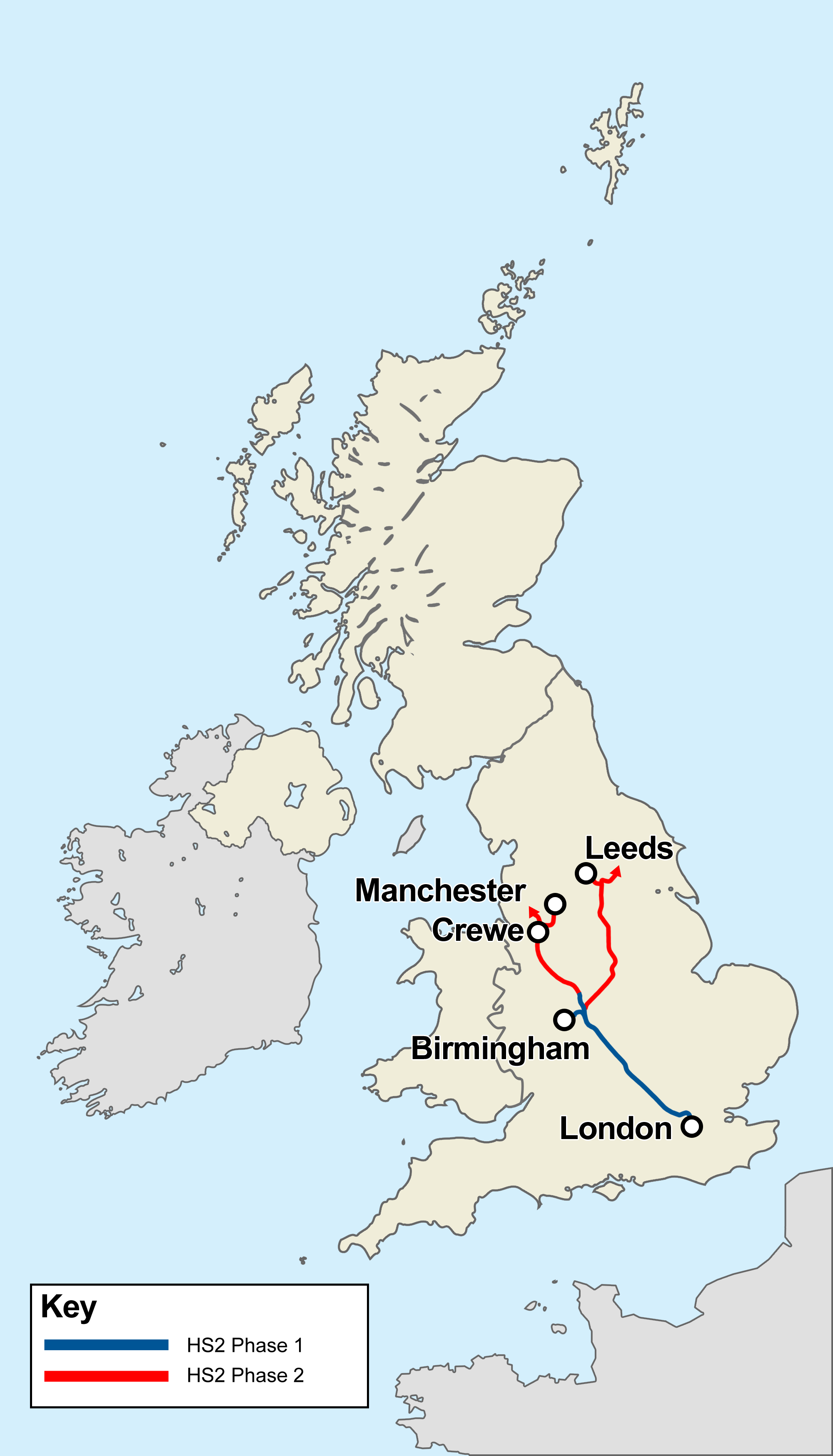
Bamfurlong is a small village in the Metropolitan Borough of Wigan, Greater Manchester, England. Location It lies approximately south of Wigan town centre and to the north east of Ashton-in-Makerfield town centre. Bamfurlong has a population of around 2,500 people. Bamfurlong is within the ward of Abram, Greater Manchester, Abram. For transport it is relatively close to the M6 motorway. Bamfurlong railway station served the village from 1832 until closure in 1950. The proposed High Speed 2 line coming from the south would connect to the West Coast Main Line at the site of the closed station, allowing high-speed services to continue north on slower tracks. No station will be built in the village. References {{authority control Villages in Greater Manchester ... [...More Info...] [...Related Items...] OR: [Wikipedia] [Google] [Baidu] |
Metropolitan Borough Of Wigan
The Metropolitan Borough of Wigan is a metropolitan borough of Greater Manchester, in North West England. It is named after the main settlement of Wigan. It covers the towns of Atherton, Ashton-in-Makerfield, Golborne, Hindley, Ince-in-Makerfield, Leigh and Tyldesley. The borough also covers the villages and suburbs of Abram, Aspull, Astley, Bryn, Hindley Green, Lowton, Mosley Common, Orrell, Pemberton, Shevington, Standish, Winstanley and Worsley Mesnes. The borough is also the second-most populous district in Greater Manchester. The borough was formed in 1974, replacing several former local government districts. It is the furthest west part of Greater Manchester, and it is bordered by the Greater Manchester boroughs of City of Salford and Bolton to the east, the Cheshire borough of Warrington to the south, the Merseyside borough of St Helens to the south west, and the Lancashire boroughs of West Lancashire to the west and Chorley to the north. History Wigan met ... [...More Info...] [...Related Items...] OR: [Wikipedia] [Google] [Baidu] |
Greater Manchester
Greater Manchester is a metropolitan county and combined authority, combined authority area in North West England, with a population of 2.8 million; comprising ten metropolitan boroughs: City of Manchester, Manchester, City of Salford, Salford, Metropolitan Borough of Bolton, Bolton, Metropolitan Borough of Bury, Bury, Metropolitan Borough of Oldham, Oldham, Metropolitan Borough of Rochdale, Rochdale, Metropolitan Borough of Stockport, Stockport, Tameside, Trafford and Metropolitan Borough of Wigan, Wigan. The county was created on 1 April 1974, as a result of the Local Government Act 1972, and designated a functional Manchester City Region, city region on 1 April 2011. Greater Manchester is formed of parts of the Historic counties of England, historic counties of Cheshire, Lancashire and the West Riding of Yorkshire. Greater Manchester spans , which roughly covers the territory of the Greater Manchester Built-up Area, the List of urban areas in the United Kingdom, second most ... [...More Info...] [...Related Items...] OR: [Wikipedia] [Google] [Baidu] |
Makerfield (UK Parliament Constituency)
Makerfield is a constituency represented in the House of Commons of the UK Parliament since 2010 by Yvonne Fovargue of the Labour Party. History This seat was formed in 1983 mostly from the Ince and Wigan seats however with some of the Leigh seat. Constituency profile Makerfield is on some calculations, particularly a historical measure based on the period of time since a previous party served the area, the safest Labour seat in the country — with its predecessor constituencies, the area has been held by Labour since the Parliamentary Labour Party was formed in 1906. In 2010 the constituency, of the 650 nationally, polled the 105th highest share of the vote for the Labour Party. However, Labour's majority fell significantly in 2019 as with many " Red Wall" seats. There is no town called Makerfield itself; instead, the name refers to the suffix of 'in-Makerfield' of the towns Ashton-in-Makerfield and Ince-in-Makerfield, though since 2010 the latter is now part of the ... [...More Info...] [...Related Items...] OR: [Wikipedia] [Google] [Baidu] |
Wigan
Wigan ( ) is a large town in Greater Manchester, England, on the River Douglas, Lancashire, River Douglas. The town is midway between the two cities of Manchester, to the south-east, and Liverpool, to the south-west. Bolton lies to the north-east and Warrington to the south. It is the largest settlement in the Metropolitan Borough of Wigan and is its administrative centre. The town has a population of 107,732 and the wider borough of 330,713. Wigan was formerly within the Historic counties of England, historic county of Lancashire. Wigan was in the territory of the Brigantes, an ancient Celtic tribe that ruled much of what is now northern England. The Brigantes were subjugated in the Roman conquest of Britain and the Roman settlement of ''Coccium'' was established where Wigan lies. Wigan was incorporated as a Borough status in the United Kingdom, borough in 1246, following the issue of a charter by Henry III of England, King Henry III of England. At the end of the Middle ... [...More Info...] [...Related Items...] OR: [Wikipedia] [Google] [Baidu] |
Bamfurlong Station - Remains, WCML Geograph-2714971-by-Ben-Brooksbank
Bamfurlong may refer to: * Bamfurlong, Gloucestershire a village in Gloucestershire, England * Bamfurlong, Greater Manchester Bamfurlong is a small village in the Metropolitan Borough of Wigan, Greater Manchester, England. Location It lies approximately south of Wigan town centre and to the north east of Ashton-in-Makerfield town centre. Bamfurlong has a population o ... a village in the Metropolitan Borough of Wigan, Greater Manchester, England * Bamfurlong (Middle-earth), a fictional place in the books of J. R. R. Tolkien {{geodis ... [...More Info...] [...Related Items...] OR: [Wikipedia] [Google] [Baidu] |
Abram, Greater Manchester
Abram is a village and electoral ward in the Metropolitan Borough of Wigan, Greater Manchester, England. It lies on flat land on the northeast bank of the Leeds and Liverpool Canal, west of Leigh, southeast of Wigan, and west of Manchester. Abram is a dormitory village with a population of 9,855. Historically part of Lancashire, Abram anciently formed a township and chapelry in the parish of Wigan and hundred of West Derby. Abram appears in an entry of an ancient survey of Lancashire in 1212 under the name "Edburgham". The urbanisation and development of Abram largely coincided with the Industrial Revolution. Abram is at the centre of a coal district, and industrial scale coal mining was introduced to Abram around the middle of the 19th century with the opening of several collieries. In 1911, Abram was described as "distinctly unpicturesque ... trees are in the minority, and stunted and blackened with smoke", with "collieries, pit-banks, and railway lines" as well as "mu ... [...More Info...] [...Related Items...] OR: [Wikipedia] [Google] [Baidu] |
M6 Motorway
The M6 motorway is the longest motorway in the United Kingdom. It is located entirely within England, running for just over from the Midlands to the border with Scotland. It begins at Junction 19 of the M1 and the western end of the A14 at the Catthorpe Interchange, near Rugby before heading north-west. It passes Coventry, Birmingham, Wolverhampton, Stoke-on-Trent, Preston, Lancaster and Carlisle before terminating at Junction 45 near Gretna. Here, just short of the Scottish border it becomes the A74(M) which continues to Glasgow as the M74. Its busiest sections are between junctions 4 and 10a in the West Midlands, and junctions 16 to 19 in Cheshire; these sections have now been converted to smart motorways. It incorporated the Preston By-pass, the first length of motorway opened in the UK and forms part of a motorway "Backbone of Britain", running north−south between London and Glasgow via the industrial North of England. It is also part of the east−west route betwe ... [...More Info...] [...Related Items...] OR: [Wikipedia] [Google] [Baidu] |
Bamfurlong Railway Station
Bamfurlong railway station served the village of Bamfurlong part of Abram, to the south of Wigan. The line before the station The line was opened by the Wigan Branch Railway (WBR) in 1832 from to as a single track with passing places although the trackbed had been engineered for double track. In 1834 the WBR became part of the North Union Railway (NUR) and they doubled the track in time for the opening of the line northwards to in 1838. From 1 January 1846 the NUR was leased jointly by the Grand Junction Railway (GJR) and the Manchester and Leeds Railway (M&LR). Later in 1846 the leases passed, by amalgamation from the GJR to the London and North Western Railway (L&NWR) and from the M&LR to the Lancashire and Yorkshire Railway. The station The station opened on 1 April 1878. It stood immediately south of Lily lane, which became the A58, as it bridged over the line in the village of Bamfurlong, from . It was located in a cutting to the west of Bamfurlong Hall. There were ... [...More Info...] [...Related Items...] OR: [Wikipedia] [Google] [Baidu] |
High Speed 2
High Speed 2 (HS2) is a planned high-speed railway line in England, the first phase of which is under construction in stages and due for completion between 2029 and 2033, depending on approval for later stages. The new line will run from its most southerly terminus, London, to its most northerly point, Manchester, with branches to Birmingham and the East Midlands. HS2 will be Britain's second purpose-built High-speed rail in the United Kingdom, high-speed line, the first being High Speed 1, which connects London to the Channel Tunnel. At its southern end, the line will terminate at London's London Euston railway station, Euston station while other termini will be Birmingham Curzon Street railway station, Birmingham Curzon Street station and Manchester Piccadilly station. In addition to these stations, the dedicated track will serve Old Oak Common railway station, Old Oak Common in west London, Birmingham Interchange, East Midlands Parkway railway station, East Midlands Parkway ... [...More Info...] [...Related Items...] OR: [Wikipedia] [Google] [Baidu] |
West Coast Main Line
The West Coast Main Line (WCML) is one of the most important railway corridors in the United Kingdom, connecting the major cities of London and Glasgow with branches to Birmingham, Liverpool, Manchester and Edinburgh. It is one of the busiest mixed-traffic railway routes in Europe, carrying a mixture of intercity rail, regional rail, commuter rail and rail freight traffic. The core route of the WCML runs from London to Glasgow for and was opened from 1837 to 1869. With additional lines deviating to Northampton, Birmingham, Manchester, Liverpool and Edinburgh, this totals a route mileage of . The Glasgow–Edinburgh via Carstairs line connects the WCML to Edinburgh, however the main London–Edinburgh route is the East Coast Main Line. Several sections of the WCML form part of the suburban railway systems in London, Coventry, Birmingham, Liverpool, Manchester and Glasgow, with many more smaller commuter stations, as well as providing links to more rural towns. It is one of the ... [...More Info...] [...Related Items...] OR: [Wikipedia] [Google] [Baidu] |
Golborne
Golborne (pronounced or ) is a town in the Metropolitan Borough of Wigan, in Greater Manchester, England. It lies south-southeast of Wigan, northeast of Warrington and to the west of the city of Manchester. Combined with the village of Lowton, it has a population of 24,041. Within the boundaries of the Historic counties of England, historic county of Lancashire, Golborne owes most of its growth to the mining and textile industries. There was also significant agricultural activity, and many farms still belong to the families who originally owned them. History Toponymy The name Golborne derives from the Old English ''golde'' and ''burna'', and means "stream where Caltha palustris, marsh marigolds grow". The earliest settlements in the present-day town were on banks of the Millingford Brook, hence its name being derived from a water course where calendula grew. Golborne has been recorded in ancient documents as Goldeburn in 1187, Goldburc in 1201, Goseburn and Goldburn in 1212 ... [...More Info...] [...Related Items...] OR: [Wikipedia] [Google] [Baidu] |


_-_geograph.org.uk_-_1072207.jpg)