|
Ballybrit
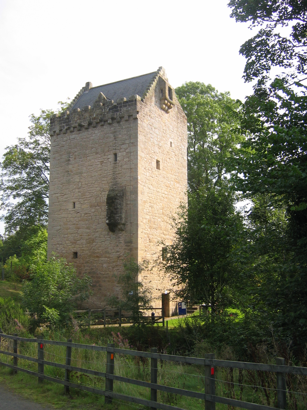
Ballybrit () is an electoral division and townland in the civil parish of St. Nicholas, on the outskirts of Galway city in Ireland. The townland of Ballybrit is in area, and is home to Ballybrit Racecourse and a business park. Evidence of ancient settlement in the area includes a medieval tower house and an earlier ringfort site. The ringfort (or ''cashel'') was used as a graveyard since at least the early 19th century. See also * List of townlands of County Galway This is a sortable table of the approximately 4,556 townlands in County Galway , Ireland. Retrieved: ... References Townlands of County Galway {{Galway-geo-stub ...[...More Info...] [...Related Items...] OR: [Wikipedia] [Google] [Baidu] |
Ballybrit Castle (geograph 2329073)
Ballybrit () is an electoral division and townland in the civil parish of St. Nicholas, on the outskirts of Galway city in Ireland. The townland of Ballybrit is in area, and is home to Ballybrit Racecourse and a business park. Evidence of ancient settlement in the area includes a medieval tower house and an earlier ringfort site. The ringfort (or ''cashel'') was used as a graveyard since at least the early 19th century. See also * List of townlands of County Galway This is a sortable table of the approximately 4,556 townlands in County Galway , Ireland. Retrieved: ... References Townlands of County Galway {{Galway-geo-stub ...[...More Info...] [...Related Items...] OR: [Wikipedia] [Google] [Baidu] |
Ballybrit Racecourse
Ballybrit Race Track, also known as Galway Racecourse, is a horse race course in County Galway, Ireland. It is located in the townland of Ballybrit, in the environs of Castlegar, just north of the N6 Bóthar na dTreabh, c.6 km northeast of Galway city. The track has two stands, the Main Stand and Millennium Stand. The 7-day Galway Races Festival is held here every August. Other meetings are held here in September (2 days), early October (1 day) and over the last weekend in October (3 days). Course information Ballybrit is a right-handed course of about one mile and three furlongs, with a steep decline into the dip where the last two fences are situated. These fences are known for being the closest two fences on any racecourse in the world. There is a sharp incline to the finish line. History The first meeting was held in 1869. As part of his visit to Ireland in 1979, Pope John Paul II celebrated mass at the racecourse for two hundred and eighty thousand people. The ... [...More Info...] [...Related Items...] OR: [Wikipedia] [Google] [Baidu] |
Galway City
Galway ( ; ga, Gaillimh, ) is a city in the West of Ireland, in the province of Connacht, which is the county town of County Galway. It lies on the River Corrib between Lough Corrib and Galway Bay, and is the sixth most populous city on the island of Ireland and the fourth most populous in the Republic of Ireland, with a population at the 2022 census of 83,456. Located near an earlier settlement, Galway grew around a fortification built by the King of Connacht in 1124. A municipal charter in 1484 allowed citizens of the by then walled city to form a council and mayoralty. Controlled largely by a group of merchant families, the Tribes of Galway, the city grew into a trading port. Following a period of decline, as of the 21st century, Galway is a tourist destination known for festivals and events including the Galway Arts Festival. In 2018, Galway was named the European Region of Gastronomy. The city was the European Capital of Culture for 2020, alongside Rijeka, Cro ... [...More Info...] [...Related Items...] OR: [Wikipedia] [Google] [Baidu] |
List Of Townlands Of County Galway
This is a sortable table of the approximately 4,556 townlands in County Galway , Ireland. Retrieved: 2010-09-08. Duplicate names occur where there is more than one townland with the same name in the county. Names marked in bold typeface are Towns (not Townlands) and villages, and the word ''Town'' appears for those entries in the Acres column. Townland list References {{reflist |
Electoral Division (Ireland)
An electoral division (ED, ) is a legally defined administrative area in the Republic of Ireland, generally comprising multiple townlands, and formerly a subdivision of urban and rural districts. Until 1996, EDs were known as district electoral divisions (DEDs, ) in the 29 county council areas and wards in the five county boroughs. Until 1972, DEDs also existed in Northern Ireland. The predecessor poor law electoral divisions were introduced throughout the island of Ireland in the 1830s. The divisions were used as local-government electoral areas until 1919 in what is now the Republic and until 1972 in Northern Ireland. History until partition Electoral divisions originated under the Poor Relief (Ireland) Act 1838 as "poor law electoral divisions": electoral divisions of a poor law union (PLU) returning one or more members to the PLU's board of guardians. The boundaries of these were drawn by Poor Law Commissioners, with the intention of producing areas roughly equivalent in ... [...More Info...] [...Related Items...] OR: [Wikipedia] [Google] [Baidu] |
Townland
A townland ( ga, baile fearainn; Ulster-Scots: ''toonlann'') is a small geographical division of land, historically and currently used in Ireland and in the Western Isles in Scotland, typically covering . The townland system is of Gaelic origin, pre-dating the Norman invasion, and most have names of Irish origin. However, some townland names and boundaries come from Norman manors, plantation divisions, or later creations of the Ordnance Survey.Connolly, S. J., ''The Oxford Companion to Irish History, page 577. Oxford University Press, 2002. ''Maxwell, Ian, ''How to Trace Your Irish Ancestors'', page 16. howtobooks, 2009. The total number of inhabited townlands in Ireland was 60,679 in 1911. The total number recognised by the Irish Place Names database as of 2014 was 61,098, including uninhabited townlands, mainly small islands. Background In Ireland a townland is generally the smallest administrative division of land, though a few large townlands are further divided into h ... [...More Info...] [...Related Items...] OR: [Wikipedia] [Google] [Baidu] |
Civil Parishes In Ireland
Civil parishes () are units of territory in the island of Ireland that have their origins in old Gaelic territorial divisions. They were adopted by the Anglo-Norman Lordship of Ireland and then by the Elizabethan Kingdom of Ireland, and were formalised as land divisions at the time of the Plantations of Ireland. They no longer correspond to the boundaries of Roman Catholic or Church of Ireland parishes, which are generally larger. Their use as administrative units was gradually replaced by Poor_law_union#Ireland, Poor Law Divisions in the 19th century, although they were not formally abolished. Today they are still sometimes used for legal purposes, such as to locate property in deeds of property registered between 1833 and 1946. Origins The Irish parish was based on the Gaelic territorial unit called a ''túath'' or ''Trícha cét''. Following the Norman invasion of Ireland, the Anglo-Normans, Anglo-Norman barons retained the ''tuath'', later renamed a parish or manor, as a un ... [...More Info...] [...Related Items...] OR: [Wikipedia] [Google] [Baidu] |
Tower House
A tower house is a particular type of stone structure, built for defensive purposes as well as habitation. Tower houses began to appear in the Middle Ages, especially in mountainous or limited access areas, in order to command and defend strategic points with reduced forces. At the same time, they were also used as an aristocrat's residence, around which a castle town was often constructed. Europe After their initial appearance in Ireland, Scotland, the Stins, Frisian lands, Basque Country (greater region), Basque Country and England during the High Middle Ages, tower houses were also built in other parts of western Europe, especially in parts of France and Italy. In Italian medieval communes, urban ''palazzi'' with a very tall tower were increasingly built by the local highly competitive Patrician (post-Roman Europe), patrician families as power centres during times of internal strife. Most north Italian cities had a number of these by the end of the Middles Ages, but few no ... [...More Info...] [...Related Items...] OR: [Wikipedia] [Google] [Baidu] |
Ringfort
Ringforts, ring forts or ring fortresses are circular fortified settlements that were mostly built during the Bronze Age up to about the year 1000. They are found in Northern Europe, especially in Ireland. There are also many in South Wales and in Cornwall, where they are called rounds. Ringforts come in many sizes and may be made of stone or earth. Earthen ringforts would have been marked by a circular rampart (a bank and ditch), often with a stakewall. Both stone and earthen ringforts would generally have had at least one building inside. Distribution Ireland In Irish language sources they are known by a number of names: ' (anglicised ''rath'', also Welsh ''rath''), ' (anglicised ''lis''; cognate with Cornish '), ' (anglicised ''cashel''), ' (anglicised ''caher'' or ''cahir''; cognate with Welsh ', Cornish and Breton ') and ' (anglicised ''dun'' or ''doon''; cognate with Welsh and Cornish ').Edwards, Nancy. ''The Archaeology of Early Medieval Ireland''. Routledge, 20 ... [...More Info...] [...Related Items...] OR: [Wikipedia] [Google] [Baidu] |
.jpg)


%2C_Co_Roscommon%2C_Ireland.jpg)