|
Bahr El-Ghazal (wadi In Chad)
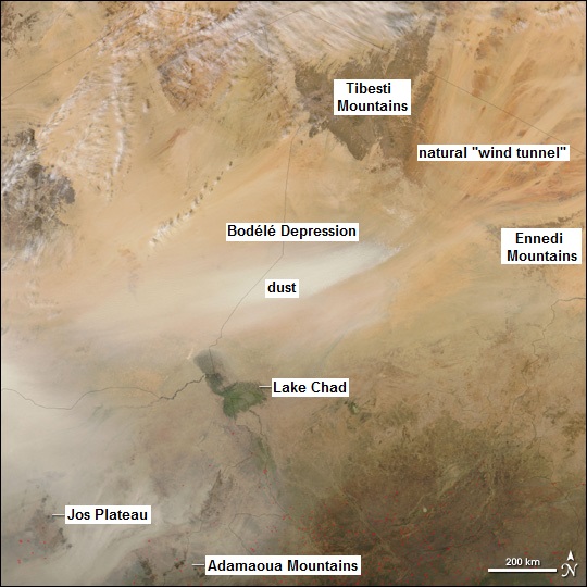
The Bahr el-Ghazal (بحر الغزال) is a wadi, or dry riverbed, in central Chad. When water flows through it (which in modern times happens only in rare, extreme rainfall events), it flows from southwest to northeast, away from Lake Chad and into the Bodélé Depression The Bodélé Depression (), located at the southern edge of the Sahara Desert in north central Africa, is the lowest point in Chad. It is 500 km long, 150 km wide and around 160 m deep. Its bottom lies about 155 meters above sea leve .... The "sill" of the Bahr el-Ghazal is the lowest point on the drainage divide between the Lake Chad and Bodélé basins. In the past, when Lake Chad filled to this point and overflowed, it was drained by the Bahr el-Ghazal. References Rivers of Chad Bahr el Ghazal {{Chad-river-stub ... [...More Info...] [...Related Items...] OR: [Wikipedia] [Google] [Baidu] |
Chad
Chad (; ar, تشاد , ; french: Tchad, ), officially the Republic of Chad, '; ) is a landlocked country at the crossroads of North and Central Africa. It is bordered by Libya to the north, Sudan to the east, the Central African Republic to the south, Cameroon to the southwest, Nigeria to the southwest (at Lake Chad), and Niger to the west. Chad has a population of 16 million, of which 1.6 million live in the capital and largest city of N'Djamena. Chad has several regions: a desert zone in the north, an arid Sahelian belt in the centre and a more fertile Sudanian Savanna zone in the south. Lake Chad, after which the country is named, is the second-largest wetland in Africa. Chad's official languages are Arabic and French. It is home to over 200 different ethnic and linguistic groups. Islam (55.1%) and Christianity (41.1%) are the main religions practiced in Chad. Beginning in the 7th millennium BC, human populations moved into the Chadian basin in great numbe ... [...More Info...] [...Related Items...] OR: [Wikipedia] [Google] [Baidu] |
Wadi
Wadi ( ar, وَادِي, wādī), alternatively ''wād'' ( ar, وَاد), North African Arabic Oued, is the Arabic term traditionally referring to a valley. In some instances, it may refer to a wet (ephemeral) riverbed that contains water only when heavy rain occurs. Etymology The term ' is very widely found in Arabic toponyms. Some Spanish toponyms are derived from Andalusian Arabic where ' was used to mean a permanent river, for example: Guadalcanal from ''wādī al-qanāl'' ( ar, وَادِي الْقَنَال, "river of refreshment stalls"), Guadalajara from ''wādī al-ḥijārah'' ( ar, وَادِي الْحِجَارَة, "river of stones"), or Guadalquivir, from ''al-wādī al-kabīr'' ( ar, اَلْوَادِي الْكَبِير, "the great river"). General morphology and processes Wadis are located on gently sloping, nearly flat parts of deserts; commonly they begin on the distal portions of alluvial fans and extend to inland sabkhas or dry lakes. In basin and r ... [...More Info...] [...Related Items...] OR: [Wikipedia] [Google] [Baidu] |
Lake Chad
Lake Chad (french: Lac Tchad) is a historically large, shallow, endorheic lake in Central Africa, which has varied in size over the centuries. According to the ''Global Resource Information Database'' of the United Nations Environment Programme, it shrank by as much as 95% from about 1963 to 1998. The lowest area was in 1986, at , but "the 2007 (satellite) image shows significant improvement over previous years." Lake Chad is economically important, providing water to more than 30 million people living in the four countries surrounding it ( Chad, Cameroon, Niger, and Nigeria) on the central part of the Sahel. It is the largest lake in the Chad Basin. Geography and hydrology The freshwater lake is located in the Sahelian zone of West-central Africa. It is located in the interior basin which used to be occupied by a much larger ancient sea sometimes called Mega Chad. The lake is historically ranked as one of the largest lakes in Africa. Its surface area varies by season as well ... [...More Info...] [...Related Items...] OR: [Wikipedia] [Google] [Baidu] |
Bodélé Depression
The Bodélé Depression (), located at the southern edge of the Sahara Desert in north central Africa, is the lowest point in Chad. It is 500 km long, 150 km wide and around 160 m deep. Its bottom lies about 155 meters above sea level. The dry endorheic basin is a major source of fertile dust essential for the Amazon rainforest. Dust storms from the Bodélé Depression occur on average about 100 days per year, one typical example being the massive dust storms that swept over West Africa and the Cape Verde Islands in February 2004.Dust Storms from Africa's Bodélé Depression ". ''Natural Hazards'', Earth Observatory, NASA. URL accessed 2006-12-29. [...More Info...] [...Related Items...] OR: [Wikipedia] [Google] [Baidu] |
Rivers Of Chad
This is a list of rivers in Chad. This list is arranged by drainage basin, with respective tributaries indented under each larger stream's name. Gulf of Guinea *''Niger River (Nigeria)'' **''Benue River (Nigeria)'' ***Mayo Kébbi Lake Chad *Chari River **Logone River ***Pendé River ***Mbéré River **Bahr Erguig **Bahr Salamat ***Bahr Azoum ****Ouadi Kadja **Ouham River ***Nana Barya **Bahr Kéita **Ko River ***Bragoto River **Bahr Aouk (Aoukalé) *Bahr el-Ghazal (wadi in Chad), Bahr el Ghazal Lake Fitri *Batha River Darfur *Wadi Howar References *Prentice-Hall, Inc., ''American World Atlas'' 1985 GEOnet Names Server {{Africa topic, List of rivers of Rivers of Chad, * Lists of rivers by country, Chad Lists of landforms of Chad, Rivers ... [...More Info...] [...Related Items...] OR: [Wikipedia] [Google] [Baidu] |


