|
Bagdad, California
Bagdad is a ghost town in the Mojave Desert, in San Bernardino County, California. Geography Bagdad is located along the historic U.S. Route 66, east of Barstow and Ludlow, and west of Amboy and Needles. The town was founded in 1883 when the Atchison, Topeka and Santa Fe Railway line between Barstow and Needles was built. At this time, Bagdad provided services to the Orange Blossom Mine several miles to the north, and to the War Eagle Mine several miles to the south. In addition, a dirt track extended south past the War Eagle Mine into the Dale Mining District in the Pinto Mountains. Bagdad was long a thriving town along the National Old Trails Road and the famous Route 66. It was bypassed by the opening of Interstate 40 to the north in 1973, and lost traveler's business and resident population. The remaining buildings were razed in 1991, leaving little trace of the town. Bagdad holds the record for the longest dry streak in United States history with 767 straight days wit ... [...More Info...] [...Related Items...] OR: [Wikipedia] [Google] [Baidu] |
Bagdad, Butte County, California
Bagdad is a former settlement and mining camp in Butte County, California, United States. It was located on the Feather River The Feather River is the principal tributary of the Sacramento River, in the Sacramento Valley of Northern California. The river's main stem is about long. Its length to its most distant headwater tributary is just over . The main stem Feather R ... downstream from Oroville. Gold was discovered at Bagdad by A.G. Simpson. Several mines operated at Bagdad, including the War Eagle Mine and the Orange Blossom Mines. References Former settlements in Butte County, California Former populated places in California {{mining-stub ... [...More Info...] [...Related Items...] OR: [Wikipedia] [Google] [Baidu] |
Amboy, California
Amboy is an unincorporated community in San Bernardino County, in California's Mojave Desert, west of Needles and east of Ludlow on historic Route 66. It is roughly northeast of Twentynine Palms. As of 2020, the town's business district still contained a post office, a historic restaurant-motel, and a Route 66 tourist shop, all operated by the town's population of four people. Geography The town is south of the Granite Mountains, Providence Mountains, and the Mojave National Preserve. Adjacent to the south is the landmark Amboy Crater, and beyond to the southeast the Bullion Mountains. To the south is Bristol Dry Lake and the community of Cadiz, California. Amboy was once a major stop along the famous Route 66, but has seen much lower visitation since the opening of Interstate 40 to the north in 1973. Amboy is home to Roy's Motel and Café, a Route 66 landmark. The town has a total of 10 surviving buildings and a population of far fewer than the advertised 20. Accordi ... [...More Info...] [...Related Items...] OR: [Wikipedia] [Google] [Baidu] |
Bagdad Cafe (TV Series)
''Bagdad Cafe'' is an American television sitcom starring Whoopi Goldberg and Jean Stapleton that aired on CBS. The series premiered March 30, 1990, and ran two seasons before being cancelled in winter 1990. The last two episodes aired in July 1991. The show is based on the 1987 Percy Adlon film ''Bagdad Cafe''. Cast * Whoopi Goldberg as Brenda * Jean Stapleton as Jasmine * James Gammon as Rudy * Monica Calhoun as Debbie * Scott Lawrence as Juney * Cleavon Little as Sal In this version, Jasmine was not German. Production The series was shot in the conventional sitcom format, in front of a studio audience. The show did not obtain a sizable audience, being forced to compete with ABC's Top 20 hit ''Family Matters'' and was cancelled after two seasons. Insiders say that production of the series ended on November 16, 1990, after a dispute between Goldberg and the show's co-executive producer, Thad Mumford. Executive producer Kenneth Kaufman was told that Goldberg called CBS presiden ... [...More Info...] [...Related Items...] OR: [Wikipedia] [Google] [Baidu] |
Newberry Springs, California
Newberry Springs is an unincorporated community in the western Mojave Desert of Southern California, located at the foot of the Newberry Mountains in San Bernardino County, California, United States. Newberry Spring is a spring that in the 19th century supplied water to the local Santa Fe Railway and originally was a camping place. The population at the 2000 census was 2,895. Geography and climate Newberry Springs is located east of Barstow, approximately due west of the Mojave National Preserve, and approximately south of Death Valley National Park. The town is in area. It is approximately above sea level. The region maintains an average daytime summer temperature of . In the winter, lows generally get into the 20s, with a dry, cold climate, the immediate area receiving less than of rain per year. Newberry Springs is a typical desert oasis. Ancient volcanic rock formations, lava beds, sand dunes, mineral springs, and hidden mud baths are found in the area. The are ... [...More Info...] [...Related Items...] OR: [Wikipedia] [Google] [Baidu] |
Bagdad Café
''Bagdad Cafe'' (sometimes ''Bagdad Café'', titled ''Out of Rosenheim'' in Germany) is a 1987 English-language West German film directed by Percy Adlon. It is a comedy-drama set in a remote truck stop and motel in the Mojave Desert in the U.S. state of California. Inspired by Carson McCullers' novella '' The Ballad of the Sad Café'' (1951), the film centers on two women who have recently separated from their husbands, and the blossoming friendship that ensues. It runs 95 minutes in the U.S. and 108 minutes in the German version. Plot German tourists Jasmin Münchgstettner (Sägebrecht) from Rosenheim and her husband fight while driving across the desert. She storms out of the car and makes her way to the isolated truck stop, which is run by the tough-as-nails and short-tempered Brenda (Pounder), whose own husband, after an argument out front, is soon to leave as well. Jasmin takes a room at the adjacent motel. Initially suspicious of the foreigner, Brenda eventually befriends Jas ... [...More Info...] [...Related Items...] OR: [Wikipedia] [Google] [Baidu] |
Motion Picture
A film also called a movie, motion picture, moving picture, picture, photoplay or (slang) flick is a work of visual art that simulates experiences and otherwise communicates ideas, stories, perceptions, feelings, beauty, or atmosphere through the use of moving images. These images are generally accompanied by sound and, more rarely, other sensory stimulations. The word "cinema", short for cinematography, is often used to refer to filmmaking and the film industry, and to the art form that is the result of it. Recording and transmission of film The moving images of a film are created by photography, photographing actual scenes with a movie camera, motion-picture camera, by photographing drawings or miniature models using traditional animation techniques, by means of computer-generated imagery, CGI and computer animation, or by a combination of some or all of these techniques, and other visual effects. Before the introduction of digital production, series of still imag ... [...More Info...] [...Related Items...] OR: [Wikipedia] [Google] [Baidu] |
Bagdad CA - Bagdad Café
{{disambiguation, geo ...
Baghdad is the capital city of Iraq. Bagdad may also refer to: Places Other * Bagdad, Tasmania, Australia * Bagdad, New Brunswick, Canada * Bagdad, Tamaulipas, Mexico * Bagdad, Poland United States * Bagdad, Arizona * Bagdad, California * Bagdad, Butte County, California * Bagdad, Florida * Bagdad, Kentucky * Bagdad, New York * Bagdad, Virginia * Bagdad, Wisconsin, a ghost town Arts and media * ''Bagdad'' (film), a 1949 American motion picture * "Bagdad" (song), a 2018 song by Rosalía * "Bagdad", a song by American band Ra * The Sala Bagdad ( es:), an erotic theater in Barcelona, Spain See also * Baghdad (other) Baghdad is the capital of Iraq. Baghdad may also refer to: Places In Iraq *Baghdad Governorate, the region encompassing the city and its surrounding areas *Baghdad Province, Ottoman Empire *Baghdad Central Station, a train station *Baghdad Inte ... [...More Info...] [...Related Items...] OR: [Wikipedia] [Google] [Baidu] |
Airway Beacon
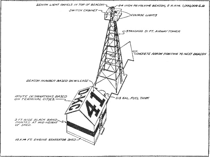
An airway beacon (US) or aerial lighthouse (UK and Europe) was a rotating light assembly mounted atop a tower. These were once used extensively in the United States for visual navigation by airplane pilots along a specified airway corridor. In Europe, they were used to guide aircraft with lighted beacons at night. UK and Europe United Kingdom A network of aerial lighthouses was established in the United Kingdom and Europe during the 1920s and 1930s. Use of the lighthouses has declined with the advent of radio navigation aids such as NDB (non-directional beacon), VOR (VHF omnidirectional ranging) and DME (distance measuring equipment). The last operational aerial lighthouse in the United Kingdom is on top of the cupola over the RAF College main hall at RAF Cranwell. Netherlands In the Netherlands, gas holders were painted with an arrow pointing north and two letters identifying their location. United States Approximately 1,500 airway beacons were constructed to guide ... [...More Info...] [...Related Items...] OR: [Wikipedia] [Google] [Baidu] |
Bullion Mountains
The Bullion Mountains are located in the Mojave Desert of California southeast of the city of Barstow. The mountain range stretches for approximately 50 miles in a northwest-southeasterly direction north of Joshua Tree and Twentynine Palms. Since most of the range lies in the Marine Corps Air Ground Combat Center Twentynine Palms The Marine Corps Air Ground Combat Center (MCAGCC), also known as 29 Palms, is the largest United States Marine Corps base. It was a census-designated place (CDP) officially known as Twentynine Palms Base located adjacent to the city of Twentynin ..., where live ammunition practices occur, almost the entire mountain range is off-limits to the public. The highest point of the range in the northwestern region is 4,669 feet (1,423) meters. References *California Road and Recreation Atlas, 2005, pg. 106 Mountain ranges of Southern California Mountain ranges of the Mojave Desert Mountain ranges of San Bernardino County, California {{SanBernardin ... [...More Info...] [...Related Items...] OR: [Wikipedia] [Google] [Baidu] |
Mojave National Preserve
Mojave National Preserve is a United States National Preserve located in the Mojave Desert of San Bernardino County, California, USA, between Interstate 15 in California, Interstate 15 and Interstate 40. The preserve was established October 31, 1994, with the passage of the California Desert Protection Act by the US Congress, which also established Joshua Tree National Park and Death Valley National Park as National park, National Parks. Previously, some lands contained within the Preserve were the East Mojave National Scenic Area, under the jurisdiction of the Bureau of Land Management. At , within the contiguous United States it is the third largest unit of the National Park System and the first largest National preserve, National Preserve. The preserve was created within the Pacific West Region of the National Park Service and remains within that jurisdiction today. Natural features include the Kelso Dunes, the Marl Mountains and the Cima Dome & Volcanic Field National Natur ... [...More Info...] [...Related Items...] OR: [Wikipedia] [Google] [Baidu] |
Granite Mountains (California)
The Granite Mountains are a small mountain range in San Bernardino County, California, USA, located in the Mojave Desert. They are in the Mojave National Preserve, in the National Park Service system. The University of California operates thGranite Mountain Natural Reserveon 9000 acres of land within the Mojave National Preserve. The Granite Mountains Natural Reserve is a research and teaching center that was established by the late ProfessoDr. Kenneth Norrisof U.C. Santa Cruz in 1978 and is now managed out of UC Riverside. Students and faculty have completed extensive studies of the natural history of the Granite Mountains since the reserve's inception. This is one of 37 reserves in thUC Natural Reserve System Geography The Granite Mountains are north of Interstate 40 in California, Interstate 40 and historic U.S. Route 66 in California, Route 66. The Providence Mountains are adjacent to the northeast. The Bristol Mountains are directly to the west, the Old Woman Mountains are ... [...More Info...] [...Related Items...] OR: [Wikipedia] [Google] [Baidu] |
Interstate 40 In California
Interstate 40 (I-40) is a major east–west Interstate Highway System, Interstate Highway in the United States, stretching from Barstow, California, to Wilmington, North Carolina. The segment of I-40 in California is sometimes called the Needles Freeway. It goes east from its western terminus at Interstate 15 in California, I-15 in Barstow across the Mojave Desert in San Bernardino County, California, San Bernardino County past the Clipper Mountains to Needles, CA, Needles, before it crosses over the Colorado River into Arizona east of Needles. All of I-40 in California are in San Bernardino County. Route description I-40 goes through the Mojave Desert on the entirety of its run through California. The highway starts its eastward journey at a junction with Interstate 15 in California, I-15 in Barstow, California, Barstow. The freeway passes through Marine Corps Logistics Base Barstow before leaving the city limits. I-40 provides access to the town of Daggett, California, D ... [...More Info...] [...Related Items...] OR: [Wikipedia] [Google] [Baidu] |


.jpg)


