|
Baekdu
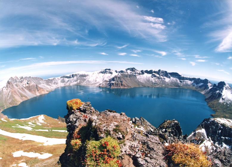
Paektu Mountain (), also known as Baekdu Mountain and in China as Changbai Mountain ( zh, s=长白山, t=長白山; Manchu: Golmin Šanggiyan Alin), is an active stratovolcano on the Chinese–North Korean border. At , it is the highest mountain of the Baekdudaegan and Changbai ranges. Koreans assign a mythical quality to the volcano and its caldera lake, considering it to be their country's spiritual home. It is the highest mountain in North Korea and Northeast China. A large crater lake, called Heaven Lake, is in the caldera atop the mountain. The caldera was formed by the VEI 7 "Millennium" or "Tianchi" eruption of 946, which erupted about of tephra. This was one of the largest and most violent eruptions in the last 5,000 years (alongside the Minoan eruption, the Hatepe eruption of Lake Taupō in around AD 180, the 1257 eruption of Mount Samalas near Mount Rinjani and the 1815 eruption of Tambora). The mountain plays an important mythological and cultural ... [...More Info...] [...Related Items...] OR: [Wikipedia] [Google] [Baidu] |
Baekdudaegan
The Baekdu-daegan is a mountain-system and watershed-crest-line which runs through almost all of the length of the Korean Peninsula, from Paektu Mountain (2,744m) in the north to the Cheonhwang-bong or "Heavenly Monarch Peak" of Jirisan (1,915m) in the south. It has 13 Jeongmaek or branch-ranges that begin on the mainline range and channel Korea's biggest rivers to the east, west and south seas. The Baekdu-daegan is important in traditional Korean geography and thought, a key aspect of Pungsujiri philosophy and practices. It is often referred to as the "spine" or "backbone" of the Korean Peninsula, and depicted in various historic and modern artworks including national maps. Under traditional Korean thought influenced by Daoism and Neo-Confucianism, Mt. Baekdu-san is regarded as the northern root-origin of the mountain-system, and conceived-of as the grand patriarch of all Korean mountains; while Jiri-san at the southern end is conceived-of as the grand matriarch of all Ko ... [...More Info...] [...Related Items...] OR: [Wikipedia] [Google] [Baidu] |
Heaven Lake
Heaven Lake (Korean: , ''Ch'ŏnji'' or ''Cheonji''; zh, 天池, ''Tiānchí''; Manchu: ''Tamun omo'' or ''Tamun juce'') is a crater lake on the border between China and North Korea. It lies within a caldera atop the volcanic Paektu Mountain, a part of the Baekdudaegan and Changbai mountain ranges. It is located partly in Ryanggang Province, North Korea, at , and partly in Jilin Province, northeastern China. Heaven Lake has been recognized as the highest volcanic lake in the world by the Shanghai Office of the ''Guinness Book of Records''. Geology and limnology The caldera which contains Heaven Lake was created by the 946 eruption of Paektu Mountain. The lake has a surface elevation of . The lake covers an area of with a south–north length of and an east–west length of . The average depth of the lake is and a maximum depth of . From mid-October to mid-June, it is typically covered with ice. History Names and legends In ancient Chinese literature, ' also refers to ' ... [...More Info...] [...Related Items...] OR: [Wikipedia] [Google] [Baidu] |
Lake Taupō
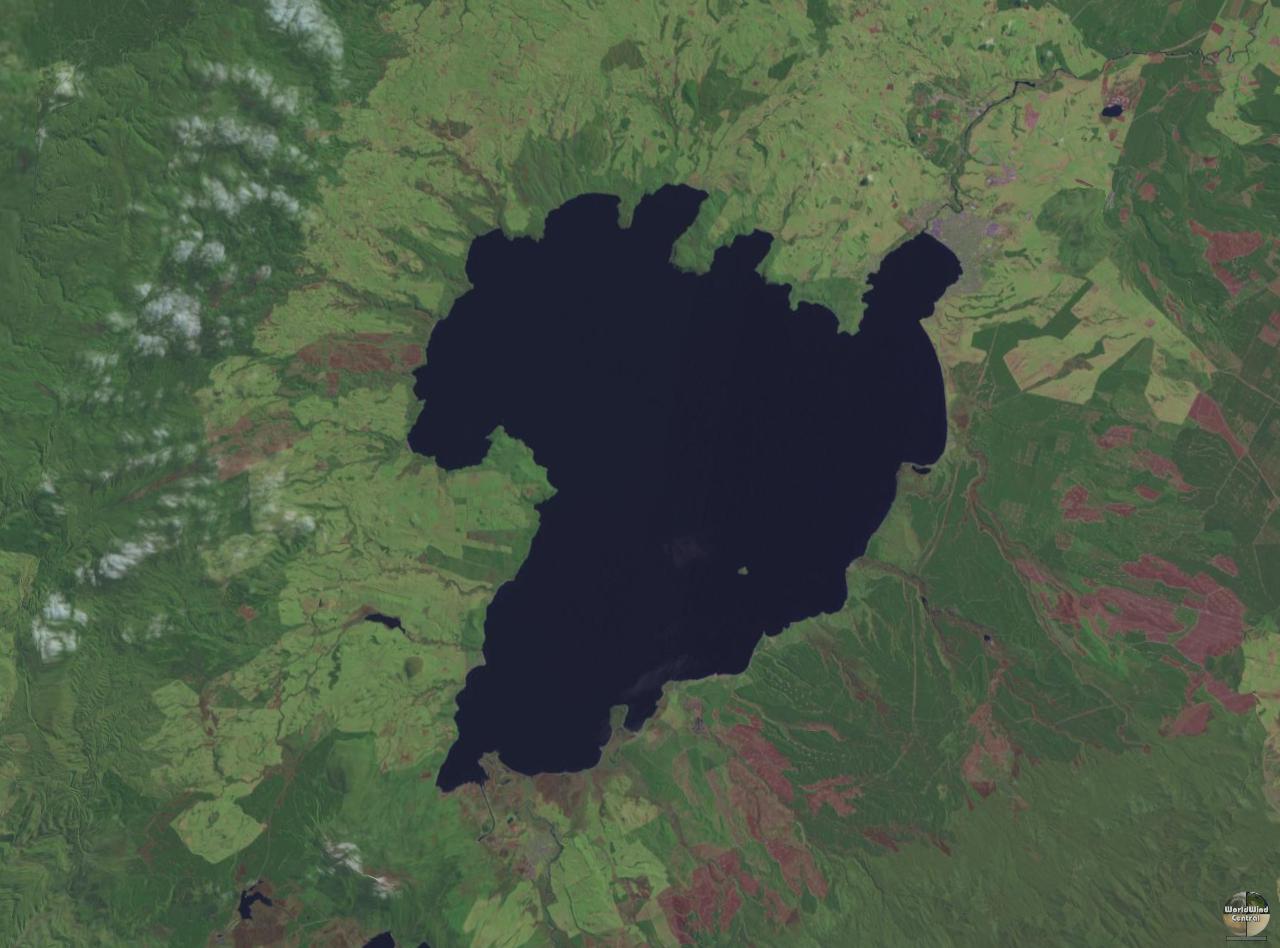
Lake Taupō (also spelled Taupo; mi, Taupō-nui-a-Tia or ) is a large crater lake in New Zealand's North Island, located in the caldera of the Taupō Volcano. The lake is the namesake of the town of Taupō, which sits on a bay in the lake's northeastern shore. With a surface area of , it is the largest lake by surface area in New Zealand, and the second largest freshwater lake by surface area in geopolitical Oceania after Lake Murray in Papua New Guinea. Motutaiko Island lies in the southeastern area of the lake. Lake Taupō has a perimeter of approximately and a maximum depth of . It is drained by the Waikato River (New Zealand's longest river), and its main tributaries are the Waitahanui River, the Tongariro River, and the Tauranga Taupō River. It is a noted trout fishery with stocks of introduced brown and rainbow trout. The level of the lake is controlled by Mercury Energy, the owner of the eight hydroelectric dams on the Waikato River downstream of Lake Taupō, usin ... [...More Info...] [...Related Items...] OR: [Wikipedia] [Google] [Baidu] |
Changbai Mountains
The Changbai Mountains (simplified Chinese:长白山; traditional Chinese:長白山) are a major mountain range in Northeast Asia that extends from the Northeast Chinese provinces of Heilongjiang, Jilin and Liaoning, across the border between China and North Korea (41°41' to 42°51'N; 127°43' to 128°16'E), to the North Korean provinces of Ryanggang and Chagang. They are also referred to as the Šanggiyan Mountains in Manchu. Most peaks exceed in height. History The mountain was first recorded in the ''Classic of Mountains and Seas'' under the name Buxian Shan (). It is also called Shanshan Daling () in the ''Book of the Later Han''. In the ''New Book of Tang'', it was called Taibai Shan ().Second Canonical Book of the Tang Dynasty. (English translation: Khitan general Li Jinzhong killed Zhao Hui, the commanding officer of Yin Zhou. Officer Dae Jung-sang, with Mohe chieftain Qisi Piyu and Goguryeo remnants, escaped to the east, crossed Liao River, guarded the northeast ... [...More Info...] [...Related Items...] OR: [Wikipedia] [Google] [Baidu] |
North Korea
North Korea, officially the Democratic People's Republic of Korea (DPRK), is a country in East Asia. It constitutes the northern half of the Korea, Korean Peninsula and shares borders with China and Russia to the north, at the Yalu River, Yalu (Amnok) and Tumen River, Tumen rivers, and South Korea to the south at the Korean Demilitarized Zone. North Korea's border with South Korea is a disputed border as both countries claim the entirety of the Korean Peninsula. The country's western border is formed by the Yellow Sea, while its eastern border is defined by the Sea of Japan. North Korea, like South Korea, its southern counterpart, claims to be the legitimate government of the entire peninsula and List of islands of North Korea, adjacent islands. Pyongyang is the capital and largest city. In 1910, Korean Empire, Korea was Korea under Japanese rule, annexed by the Empire of Japan. In 1945, after the Surrender of Japan, Japanese surrender at the End of World War II in Asia, end ... [...More Info...] [...Related Items...] OR: [Wikipedia] [Google] [Baidu] |
Caldera
A caldera ( ) is a large cauldron-like hollow that forms shortly after the emptying of a magma chamber in a volcano eruption. When large volumes of magma are erupted over a short time, structural support for the rock above the magma chamber is gone. The ground surface then collapses into the emptied or partially emptied magma chamber, leaving a large depression at the surface (from one to dozens of kilometers in diameter). Although sometimes described as a Volcanic crater, crater, the feature is actually a type of sinkhole, as it is formed through subsidence and collapse rather than an explosion or impact. Compared to the thousands of volcanic eruptions that occur each century, the formation of a caldera is a rare event, occurring only a few times per century. Only seven caldera-forming collapses are known to have occurred between 1911 and 2016. More recently, a caldera collapse occurred at Kīlauea, Hawaii in 2018. Etymology The term ''caldera'' comes from Spanish language, S ... [...More Info...] [...Related Items...] OR: [Wikipedia] [Google] [Baidu] |
Volcanic Crater Lake
A volcanic crater lake is a lake in a crater that was formed by explosive activity or a collapse during a volcanic eruption. Formation Lakes in calderas fill large craters formed by the collapse of a volcano during an eruption. Lakes in maars fill medium-sized craters where an eruption deposited debris around a vent. Crater lakes form as the created depression, within the crater rim, is filled by water. The water may come from precipitation, groundwater circulation (often hydrothermal fluids in the case of volcanic craters) or melted ice. Its level rises until an equilibrium is reached between the rates of incoming and outgoing water. Sources of water loss singly or together may include evaporation, subsurface seepage, and, in places, surface leakage or overflow when the lake level reaches the lowest point on its rim. At such a saddle location, the upper portion of the lake is contained only by its adjacent natural volcanic dam; continued leakage through or surface outflow ac ... [...More Info...] [...Related Items...] OR: [Wikipedia] [Google] [Baidu] |
Mount Rinjani
Mount Rinjani ( id, Gunung Rinjani) is an active volcano in Indonesia on the island of Lombok. Administratively the mountain is in the Regency of North Lombok, West Nusa Tenggara (Indonesian: ''Nusa Tenggara Barat'', NTB). It rises to , making it the second highest volcano in Indonesia. It is also the highest point in the Indonesian province of West Nusa Tenggara. Adjacent to the volcano is a caldera, which is filled partially by the crater lake known as Segara Anak or Anak Laut (''Child of the Sea''), due to the color of its water, as blue as the sea (''laut''). This lake is approximately above sea level and estimated to be about deep; the caldera also contains hot springs. Sasak tribe and Hindu people assume the lake and the mount are sacred and some religious activities are occasionally done in the two areas. UNESCO made Mount Rinjani Caldera a part of the Global Geoparks Network in April 2018. Geography Lombok is one of the Lesser Sunda Islands, a small archipelago ... [...More Info...] [...Related Items...] OR: [Wikipedia] [Google] [Baidu] |
1257 Samalas Eruption
In 1257, a catastrophic eruption occurred at the Samalas volcano on the Indonesian island of Lombok. The event had a probable Volcanic Explosivity Index of 7, making it one of the largest volcanic eruptions during the current Holocene epoch. It left behind a large caldera that contains Lake Segara Anak. Later volcanic activity created more volcanic centres in the caldera, including the Barujari cone, which remains active. The event created eruption columns reaching tens of kilometres into the atmosphere and pyroclastic flows that buried much of Lombok and crossed the sea to reach the neighbouring island of Sumbawa. The flows destroyed human habitations, including the city of Pamatan, which was the capital of a kingdom on Lombok. Ash from the eruption fell as far as away in Java; the volcano deposited more than of rocks and ash. The aerosols injected into the atmosphere reduced the solar radiation reaching the Earth's surface, causing a volcanic winter and cooling the atmospher ... [...More Info...] [...Related Items...] OR: [Wikipedia] [Google] [Baidu] |
1815 Eruption Of Mount Tambora
Mount Tambora is a volcano on the island of Sumbawa in present-day Indonesia, then part of the Dutch East Indies, and its 1815 eruption was the most powerful volcanic eruption in recorded human history. This volcanic explosivity index (VEI) 7 eruption ejected of material into the atmosphere, and was the most recent confirmed VEI-7 eruption. Although the Mount Tambora eruption reached a violent climax on 10 April 1815, increased steaming and small phreatic eruptions occurred during the next six months to three years. The ash from the eruption column dispersed around the world and lowered global temperatures in an event sometimes known as the Year Without a Summer in 1816. This brief period of significant climate change triggered extreme weather and harvest failures in many areas around the world. Several climate forcings coincided and interacted in a systematic manner that has not been observed after any other large volcanic eruption since the early Stone Age. Chronology of th ... [...More Info...] [...Related Items...] OR: [Wikipedia] [Google] [Baidu] |
Northeast China
Northeast China or Northeastern China () is a geographical region of China, which is often referred to as "Manchuria" or "Inner Manchuria" by surrounding countries and the West. It usually corresponds specifically to the three provinces east of the Greater Khingan Range, namely Liaoning, Jilin, and Heilongjiang, but historically is meant to also encompass the four easternmost prefectures of Inner Mongolia west of the Greater Khingan. The heartland of the region is the Northeast China Plain, the largest plain in China, with an area over . It is separated from Russian Far East to the north by the Amur, Argun, and Ussuri rivers; from Korea to the south by the Yalu and Tumen Rivers; and from Inner Mongolia to the west by the Greater Khingan and parts of the Xiliao River. Due to the shrinking of its once-powerful industrial sector and decline of its economic growth and population, the region is often referred to as China's Rust Belt. As a result, a campaign named Northeast Area Re ... [...More Info...] [...Related Items...] OR: [Wikipedia] [Google] [Baidu] |
Minoan Eruption
The Minoan eruption was a catastrophic Types of volcanic eruptions, volcanic eruption that devastated the Aegean Islands, Aegean island of Thera (also called Santorini) circa 1600 BCE. It destroyed the Minoan civilization, Minoan settlement at Akrotiri (prehistoric city), Akrotiri, as well as communities and agricultural areas on nearby islands and the coast of Crete with subsequent earthquakes and tsunamis. With a Volcanic Explosivity Index, VEI magnitude between 6 and 7, resulting in an ejection of approximately of dense-rock equivalent (DRE), the eruption was List of known large volcanic eruptions, one of the largest volcanic events on Earth in human history. Since tephra from the Minoan eruption serves as a marker horizon in nearly all archaeological sites in the Eastern Mediterranean, its precise date is of high importance and has been fiercely debated among archaeologists and volcanologists for decades, without coming to a definite conclusion. Although there are no clear ... [...More Info...] [...Related Items...] OR: [Wikipedia] [Google] [Baidu] |


