|
Badsey Brook
The Badsey Brook, also known as the Broadway Brook, is a small brook that flows through Worcestershire, England. It is a lower tributary of the River Avon, which it joins near Offenham upstream of Evesham. Its principal tributary is the Bretforton Brook. Course It rises on the flanks of the Cotswold Hills near Snowshill, and flows in a north-westerly direction through Broadway, and Childswickham before turning north and passing Wickhamford where it is crossed by the A44. The brook is then joined by a couple of minor tributaries, before flowing through Badsey then Aldington where it meets the Bretforton Brook. Turning north-west, it flows past Offenham Cross where it is bridged by the B5410, to join the Warwickshire Avon south of Offenham. Hydrology The flow of the Badsey Brook has been measured, in its lower reaches at Offenham since 1968. The gauging station was initially a flume, later changed to a weir. This long-term record shows that the catchment of to the gaugin ... [...More Info...] [...Related Items...] OR: [Wikipedia] [Google] [Baidu] |
Childswickham
Childswickham is a village in Worcestershire, England, situated within the flat open landscape of the Vale of Evesham, between the Bredon and Cotswold Hills, two miles from Broadway. It is an area predominantly of market gardening, arable and pasture land, with surrounding fields defined by hedgerows. Being on the edge of the North Cotswolds it has a mixture of building styles, from Cotswold limestone to red brick, to the more traditional Worcestershire black and white half timber and thatch. The earliest buildings are timber framed with wattle and daub and Cotswold limestone. The name Childswickham is believed to have derived from 'Child', the young son of a nobleman, 'wick', a clearing in the wood and 'ham', short for hamlet. Its history can be traced back to Roman times as coins and pottery of this era were found in fields on the old Roman road from Worcester to London which came through the village. The 15th century spire of the original Norman church, St Mary the Virgin, ... [...More Info...] [...Related Items...] OR: [Wikipedia] [Google] [Baidu] |
Badsey
Badsey is a village and civil parish in the Wychavon district of Worcestershire, England. It has two parks and a small first school located in the centre of the village. Location The village of Badsey is located about two miles east of Evesham, in the Vale of Evesham. It lies close to the River Avon. According to the 2001 census the Badsey ward had a population of 2,657. Amenities and history Badsey has a long and rich history dating back to at least Roman times. In a charter of 709, the village was referred to as Baddesia (Baeddi's Island). The floods of 2007 remind us of how Badsey came to get its name when the village became an island for one night. The Domesday Book of 1085 tells us that there were 12 villagers (likely to mean households or smallholdings) with 8 ploughs, 4 slaves and one widow living in Badsey. The reference to 8 plough teams implies that arable farming was already well established. The first stone church was probably built at Badsey in the 11th cent ... [...More Info...] [...Related Items...] OR: [Wikipedia] [Google] [Baidu] |
List Of Rivers Of England
This is a list of rivers of England, organised geographically and taken anti-clockwise around the English coast where the various rivers discharge into the surrounding seas, from the Solway Firth on the Scottish border to the Welsh Dee on the Welsh border, and again from the Wye on the Welsh border anti-clockwise to the Tweed on the Scottish border. Tributaries are listed down the page in an upstream direction, i.e. the first tributary listed is closest to the sea, and tributaries of tributaries are treated similarly. Thus, in the first catchment below, the River Sark is the lowermost tributary of the Border Esk and the Hether Burn is the lowermost tributary of the River Lyne. The main stem (or principal) river of a catchment is labelled as (MS), left-bank tributaries are indicated by (L), right-bank tributaries by (R). Note that in general usage, the 'left (or right) bank of a river' refers to the left (or right) hand bank, as seen when looking downstream. Where a named river ... [...More Info...] [...Related Items...] OR: [Wikipedia] [Google] [Baidu] |
Balancing Lake
A balancing lake (also flood basin or Sustainable urban drainage scheme) is a term used in the U.K. describing an element of an urban drainage system used to control flooding by temporarily storing flood waters. The term balancing pond is also used, though typically for smaller storage facilities for streams and brooks. In open countryside, heavy rainfall soaks into the ground and is released relatively slowly into watercourses (ditches, streams, rivers). In an urban area, the extent of hard surfaces (roofs, roads) means that the rainfall is dumped immediately into the drainage system. If left unchecked, this will cause widespread flooding downstream. The function of a balancing lake is to contain this surge and release it slowly. Failure to do this, especially in older settlements without separate storm sewers and foul sewers, can cause serious pollution as well as flooding. Engineering At its simplest, a balancing lake can be constructed by creating a dam across a drain ... [...More Info...] [...Related Items...] OR: [Wikipedia] [Google] [Baidu] |
2007 United Kingdom Floods
A series of large floods occurred in parts of the United Kingdom during the summer of 2007. The worst of the flooding occurred across Scotland on 14 June; East Yorkshire and the Midlands on 15 June; Yorkshire, the Midlands, Gloucestershire, Herefordshire and Worcestershire on 25 June; and Gloucestershire, Herefordshire, Worcestershire, Oxfordshire, Berkshire and South Wales on 28 July 2007. June was one of the wettest months on record in Britain (see List of weather records). Average rainfall across the country was ; more than double the June average. Some areas received a month's worth of precipitation in 24 hours. It was Britain's wettest May–July period since records began in 1776. July had unusually unsettled weather and above-average rainfall through the month, peaking on 20 July as an active frontal system dumped more than of rain in southern England. Civil and military authorities described the June and July rescue efforts as the biggest in peacetime Britain. The Envi ... [...More Info...] [...Related Items...] OR: [Wikipedia] [Google] [Baidu] |
Broadway Tower, Worcestershire
Broadway Tower is a folly on Broadway Hill, near the large village of Broadway, in the English county of Worcestershire, at the second-highest point of the Cotswolds (after Cleeve Hill). Broadway Tower's base is 1,024 feet (312 metres) above sea level. The tower itself stands 65 feet (20 metres) tall. While a folly, it is functional in the sense there are rooms inside. History The 'Saxon' tower was the brainchild of Capability Brown and designed by James Wyatt in 1794 in the form of a castle, and built for Barbara, Countess of Coventry in 1798–1799. The tower was built on a beacon hill, where beacons were lit on special occasions. Lady Coventry wondered whether a beacon on this hill could be seen from her house in Worcester—about away—and sponsored the construction of the folly to find out. Indeed, the beacon could be seen clearly. For some years, the tower became home to the printing press of Sir Thomas Phillipps. By the mid-1870s, it was being rented by C J Stone a ... [...More Info...] [...Related Items...] OR: [Wikipedia] [Google] [Baidu] |
Catchment
A drainage basin is an area of land where all flowing surface water converges to a single point, such as a river mouth, or flows into another body of water, such as a lake or ocean. A basin is separated from adjacent basins by a perimeter, the ''drainage divide'', made up of a succession of elevated features, such as ridges and hills. A basin may consist of smaller basins that merge at river confluences, forming a hierarchical pattern. Other terms for a drainage basin are catchment area, catchment basin, drainage area, river basin, water basin, and impluvium. In North America, they are commonly called a watershed, though in other English-speaking places, "watershed" is used only in its original sense, that of a drainage divide. In a closed drainage basin, or endorheic basin, the water converges to a single point inside the basin, known as a sink, which may be a permanent lake, a dry lake, or a point where surface water is lost underground. Drainage basins are similar but no ... [...More Info...] [...Related Items...] OR: [Wikipedia] [Google] [Baidu] |
Weir
A weir or low head dam is a barrier across the width of a river that alters the flow characteristics of water and usually results in a change in the height of the river level. Weirs are also used to control the flow of water for outlets of lakes, ponds, and reservoirs. There are many weir designs, but commonly water flows freely over the top of the weir crest before cascading down to a lower level. Etymology There is no single definition as to what constitutes a weir and one English dictionary simply defines a weir as a small dam, likely originating from Middle English ''were'', Old English ''wer'', derivative of root of ''werian,'' meaning "to defend, dam". Function Commonly, weirs are used to prevent flooding, measure water discharge, and help render rivers more navigable by boat. In some locations, the terms dam and weir are synonymous, but normally there is a clear distinction made between the structures. Usually, a dam is designed specifically to impound water behind ... [...More Info...] [...Related Items...] OR: [Wikipedia] [Google] [Baidu] |
Flume
A flume is a human-made channel for water, in the form of an open declined gravity chute whose walls are raised above the surrounding terrain, in contrast to a trench or ditch. Flumes are not to be confused with aqueducts, which are built to transport water, rather than transporting materials using flowing water as a flume does. Flumes route water from a diversion dam or weir to a desired materiel collection location. Flumes are usually made up of wood, metal or concrete. Many flumes took the form of wooden troughs elevated on trestles, often following the natural contours of the land. Originating as a part of a mill race, they were later used in the transportation of logs in the logging industry, known as a log flume. They were also extensively used in hydraulic mining and working placer deposits for gold, tin and other heavy minerals. Etymology The term ''flume'' comes from the Old French word ''flum'', from the Latin ''flumen'', meaning a river. It was formerly used for a st ... [...More Info...] [...Related Items...] OR: [Wikipedia] [Google] [Baidu] |
Gauging Station
A stream gauge, streamgage or stream gauging station is a location used by hydrologists or environmental scientists to monitor and test terrestrial bodies of water. Hydrometric measurements of water level surface elevation ("stage") and/or volumetric discharge (flow) are generally taken and observations of biota and water quality may also be made. The locations of gauging stations are often found on topographical maps. Some gauging stations are highly automated and may include telemetry capability transmitted to a central data logging facility. Measurement equipment Automated direct measurement of streamflow discharge is difficult at present. In place of the direct measurement of streamflow discharge, one or more surrogate measurements can be used to produce discharge values. In the majority of cases, a stage (the elevation of the water surface) measurement is used as the surrogate. Low gradient (or shallow-sloped) streams are highly influenced by variable downstream c ... [...More Info...] [...Related Items...] OR: [Wikipedia] [Google] [Baidu] |
Aldington, Worcestershire
Aldington is a village and civil parish in the Wychavon district of Worcestershire Worcestershire ( , ; written abbreviation: Worcs) is a county in the West Midlands of England. The area that is now Worcestershire was absorbed into the unified Kingdom of England in 927, at which time it was constituted as a county (see H ..., England. It is about three miles east of Evesham, and according to the census of 2001, had a population of 232. References External links *History of Aldington * [...More Info...] [...Related Items...] OR: [Wikipedia] [Google] [Baidu] |
A44 Road
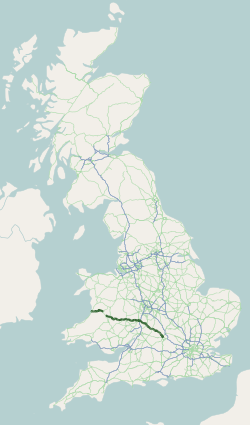
The A44 is a major road in the United Kingdom that runs from Oxford in southern England to Aberystwyth in west Wales. History The original (1923) route of the A44 was Chipping Norton to Aberystwyth. No changes were made to the route of the A44 in the early years. After the Second World War, the section between Rhayader and Llangurig was renumbered A470, as part of the long road in Wales that connects Cardiff on the south coast to Llandudno on the north coast. The A44 was extended to Oxford in the 1990s, replacing part of the A34 when the M40 motorway was completed. Route Oxford–Evesham The road begins at a roundabout junction with the A40 road on the northern section of Oxford's ring road in Oxfordshire. It has a grade separated junction with the A34 road (leading to the M40 motorway and Winchester). From here, the road runs northwest, and has a section of dual-carriageway through the villages of Yarnton and Begbroke before reaching the town of Woodstock, home to ... [...More Info...] [...Related Items...] OR: [Wikipedia] [Google] [Baidu] |


