|
Buiston Loch
Buiston Loch (NS 416 433) (locally pronounced ),Crone, Page 1 also known as Buston, Biston, and Mid Buiston was situated in the mid-Ayrshire clayland at an altitude of 90 m OD. The loch was natural, sitting in a hollow created by glaciation. The loch waters drained via the Garrier Burn that joins the Bracken and Lochridge Burns before joining the River Irvine. It has been drained since the early 18th century, and is now only visible as an often flooded surface depression in pastureland situated in a low-lying area close to the A735 road between the farms and dwellings of Lochside, Buistonend and Mid-Buiston in the Parishes of Kilmaurs and Stewarton, East Ayrshire, Scotland. It is well documented through the presence of a 2000 year old crannog, first excavated 1880-1 and then documented by Dr. Duncan McNaught, the Kilmaurs parochial schoolmaster.McNaught, Page 40 Dr R. Munro and others.Arch Hist Coll, Page 19 History Blaeu's map of 1654, based on Timothy Pont's work of the late ... [...More Info...] [...Related Items...] OR: [Wikipedia] [Google] [Baidu] |
Loch
''Loch'' () is the Scottish Gaelic, Scots and Irish word for a lake or sea inlet. It is cognate with the Manx lough, Cornish logh, and one of the Welsh words for lake, llwch. In English English and Hiberno-English, the anglicised spelling lough is commonly found in place names; in Lowland Scots and Scottish English, the spelling "loch" is always used. Many loughs are connected to stories of lake-bursts, signifying their mythical origin. Sea-inlet lochs are often called sea lochs or sea loughs. Some such bodies of water could also be called firths, fjords, estuaries, straits or bays. Background This name for a body of water is Insular CelticThe current form has currency in the following languages: Scottish Gaelic, Irish, Manx, and has been borrowed into Lowland Scots, Scottish English, Irish English and Standard English. in origin and is applied to most lakes in Scotland and to many sea inlets in the west and north of Scotland. The word comes from Proto-Indo-Eur ... [...More Info...] [...Related Items...] OR: [Wikipedia] [Google] [Baidu] |
Historic Scotland
Historic Scotland ( gd, Alba Aosmhor) was an executive agency of the Scottish Office and later the Scottish Government from 1991 to 2015, responsible for safeguarding Scotland's built heritage, and promoting its understanding and enjoyment. Under the terms of a Bill of the Scottish Parliament published on 3 March 2014, Historic Scotland was dissolved and its functions were transferred to Historic Environment Scotland (HES) on 1 October 2015. HES also took over the functions of the Royal Commission on the Ancient and Historical Monuments of Scotland. Role Historic Scotland was a successor organisation to the Ancient Monuments Division of the Ministry of Works and the Scottish Development Department. It was created as an agency in 1991 and was attached to the Scottish Executive Education Department, which embraces all aspects of the cultural heritage, in May 1999. As part of the Scottish Government, Historic Scotland was directly accountable to the Scottish Ministers. ... [...More Info...] [...Related Items...] OR: [Wikipedia] [Google] [Baidu] |
Crannogs In Scotland
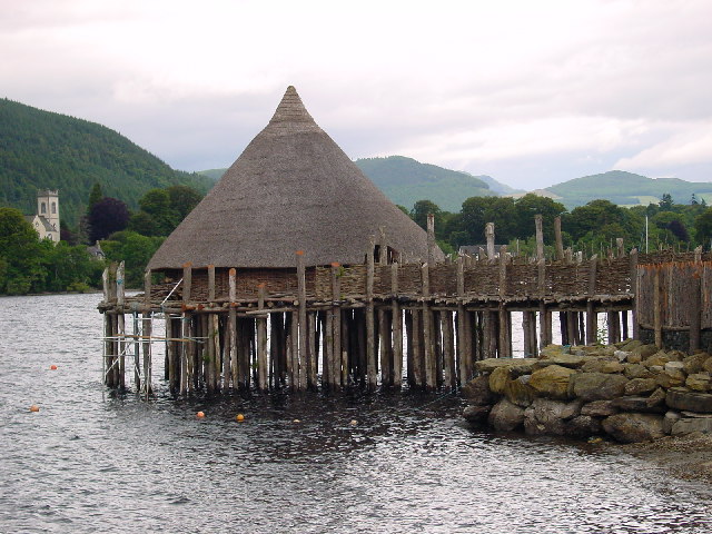
A crannog (; ga, crannóg ; gd, crannag ) is typically a partially or entirely artificial island, usually built in lakes and estuarine waters of Scotland, Wales, and Ireland. Unlike the prehistoric pile dwellings around the Alps, which were built on the shores and not inundated until later, crannogs were built in the water, thus forming artificial islands. Crannogs were used as dwellings over five millennia, from the European Neolithic Period to as late as the 17th/early 18th century. In Scotland there is no convincing evidence in the archaeological record of Early and Middle Bronze Age or Norse Period use. The radiocarbon dating obtained from key sites such as Oakbank and Redcastle indicates at a 95.4 per cent confidence level that they date to the Late Bronze Age to Early Iron Age. The date ranges fall ''after'' around 800 BC and so could be considered Late Bronze Age by only the narrowest of margins. Crannogs have been variously interpreted as free-standing wooden stru ... [...More Info...] [...Related Items...] OR: [Wikipedia] [Google] [Baidu] |
Iron Age Sites In Scotland
Iron () is a chemical element with symbol Fe (from la, ferrum) and atomic number 26. It is a metal that belongs to the first transition series and group 8 of the periodic table. It is, by mass, the most common element on Earth, right in front of oxygen (32.1% and 30.1%, respectively), forming much of Earth's outer and inner core. It is the fourth most common element in the Earth's crust. In its metallic state, iron is rare in the Earth's crust, limited mainly to deposition by meteorites. Iron ores, by contrast, are among the most abundant in the Earth's crust, although extracting usable metal from them requires kilns or furnaces capable of reaching or higher, about higher than that required to smelt copper. Humans started to master that process in Eurasia during the 2nd millennium BCE and the use of iron tools and weapons began to displace copper alloys, in some regions, only around 1200 BCE. That event is considered the transition from the Bronze Age to the Iron Ag ... [...More Info...] [...Related Items...] OR: [Wikipedia] [Google] [Baidu] |
Bronze Age Scotland
Archaeology and geology continue to reveal the secrets of prehistoric Scotland, uncovering a complex past before the Romans brought Scotland into the scope of recorded history. Successive human cultures tended to be spread across Europe or further afield, but focusing on this particular geographical area sheds light on the origin of the widespread remains and monuments in Scotland, and on the background to the history of Scotland. The extent of open countryside untouched by intensive farming, together with past availability of stone rather than timber, has given Scotland a wealth of accessible sites where the ancient past can be seen. The remote prehistory of Scotland Scotland is geologically alien to Europe, comprising a sliver of the ancient continent of Laurentia (which later formed the bulk of North America). During the Cambrian period the crustal region which became Scotland formed part of the continental shelf of Laurentia, then still south of the equator. Laurentia was s ... [...More Info...] [...Related Items...] OR: [Wikipedia] [Google] [Baidu] |
Lochs Of East Ayrshire
''Loch'' () is the Scottish Gaelic, Scots and Irish word for a lake or sea inlet. It is cognate with the Manx lough, Cornish logh, and one of the Welsh words for lake, llwch. In English English and Hiberno-English, the anglicised spelling lough is commonly found in place names; in Lowland Scots and Scottish English, the spelling "loch" is always used. Many loughs are connected to stories of lake-bursts, signifying their mythical origin. Sea-inlet lochs are often called sea lochs or sea loughs. Some such bodies of water could also be called firths, fjords, estuaries, straits or bays. Background This name for a body of water is Insular CelticThe current form has currency in the following languages: Scottish Gaelic, Irish, Manx, and has been borrowed into Lowland Scots, Scottish English, Irish English and Standard English. in origin and is applied to most lakes in Scotland and to many sea inlets in the west and north of Scotland. The word comes from Proto-Indo ... [...More Info...] [...Related Items...] OR: [Wikipedia] [Google] [Baidu] |
James Paterson (journalist)
James Paterson (18 May 1805 – 6 May 1876) was a Scottish journalist on numerous newspapers, writer and antiquary. His works are popular history, rather than scholarly. Life He was the son of James Paterson, farmer at Struthers, Ayrshire, where he was born on 18 May 1805; his father then had money troubles and gave up his farm. Paterson received an education, and then was apprenticed to a printer at the office of the Kilmarnock ''Mirror''. Subsequently he was transferred to the ''Courier'' office in Ayr. On completing his apprenticeship, Paterson went to Glasgow, where he joined the ''Scots Times''. In 1826 he returned to Kilmarnock, took a shop as stationer and printer, and in partnership with other gentlemen started the Kilmarnock ''Chronicle''. Its first number appeared on 4 May 1831, during the agitation for the Great Reform Bill, and the paper closed in May 1832. In 1835 Paterson left Kilmarnock for Dublin, where for some time he acted as correspondent of the Glasgow ... [...More Info...] [...Related Items...] OR: [Wikipedia] [Google] [Baidu] |
Loch Tay
Loch Tay ( gd, Loch Tatha) is a freshwater loch in the central highlands of Scotland, in the Perth and Kinross and Stirling council areas. It is the largest body of fresh water in Perth and Kinross, and the sixth largest loch in Scotland. The watershed of Loch Tay traditionally formed the historic province of Breadalbane. It is a long, narrow loch of around long, and typically around wide, following the line of the strath from the south west to north east. It is the sixth-largest loch in Scotland by area and over deep at its deepest. Pre-history and archaeology Between 1996 and 2005, a large scale project was carried out to investigate the heritage and archaeology of Loch Tay, the Ben Lawers Historic Landscape (BLHL) Project. It took place primarily on the National Trust for Scotland’s property but included some local landowners who held the agricultural lands between the head-dyke and the loch-shore. Mesolithic period Before 1996 the earliest known evidence for ... [...More Info...] [...Related Items...] OR: [Wikipedia] [Google] [Baidu] |
Kingdom Of Strathclyde
Strathclyde (lit. " Strath of the River Clyde", and Strað-Clota in Old English), was a Brittonic successor state of the Roman Empire and one of the early medieval kingdoms of the Britons, located in the region the Welsh tribes referred to as Yr Hen Ogledd (“the Old North"), which comprised the Brythonic-speaking parts of what is now southern Scotland and northern England. The kingdom developed during Britain's post-Roman period. It is also known as ''Alt Clut'', a Brittonic term for Dumbarton Castle, the medieval capital of the region. It may have had its origins with the Damnonii people of Ptolemy's ''Geography''. The language of Strathclyde is known as Cumbric, a language that is closely related to Old Welsh, and, among modern languages, is most closely related to Welsh, Cornish, and Breton. Scottish toponymy and archaeology points to some later settlement by Vikings or Norse–Gaels (see Scandinavian Scotland), although to a lesser degree than in neighbouring Gall ... [...More Info...] [...Related Items...] OR: [Wikipedia] [Google] [Baidu] |
Brythonic Languages
The Brittonic languages (also Brythonic or British Celtic; cy, ieithoedd Brythonaidd/Prydeinig; kw, yethow brythonek/predennek; br, yezhoù predenek) form one of the two branches of the Insular Celtic language family; the other is Goidelic. The name ''Brythonic'' was derived by Welsh Celticist John Rhys from the Welsh word , meaning Ancient Britons as opposed to an Anglo-Saxon or Gael. The Brittonic languages derive from the Common Brittonic language, spoken throughout Great Britain during the Iron Age and Roman period. In the 5th and 6th centuries emigrating Britons also took Brittonic speech to the continent, most significantly in Brittany and Britonia. During the next few centuries the language began to split into several dialects, eventually evolving into Welsh, Cornish, Breton, Cumbric, and probably Pictish. Welsh and Breton continue to be spoken as native languages, while a revival in Cornish has led to an increase in speakers of that language. Cumbric and Pic ... [...More Info...] [...Related Items...] OR: [Wikipedia] [Google] [Baidu] |
Damnonii
The Damnonii (also referred to as Damnii) were a Brittonic people of the late 2nd century who lived in what became the Kingdom of Strathclyde by the Early Middle Ages, and is now southern Scotland. They are mentioned briefly in Ptolemy's ''Geography'', where he uses both of the terms "Damnonii" and "Damnii" to describe them, and there is no other historical record of them, except arguably by Gildas three centuries later. Their cultural and linguistic affinity is presumed to be Brythonic. However, there is no unbroken historical record, and a partly Pictish origin is not precluded. The Romans under Agricola had campaigned in the area in 81, and it was Roman-occupied (at least nominally) between the time that Hadrian's Wall was built (c. 122), through the building of the Antonine Wall (c. 142), until the pullback to Hadrian's Wall in 164. Ptolemy's ''Geography'' was written within this timeframe, so his account is contemporary. Etymology The tribe's name is nearly identical to ... [...More Info...] [...Related Items...] OR: [Wikipedia] [Google] [Baidu] |
Lochlea, South Ayrshire
Lochlea or Lochlie (pronounced 'Lochli') was situated in a low-lying area between the farms and dwellings of Lochlea and Lochside in the Parish of Tarbolton, South Ayrshire, Scotland. The loch was natural, sitting in a hollow created by glaciation. The loch waters ultimately drained via Fail Loch, the Mill Burn, and the Water of Fail. It is well-documented due to the presence of a crannog that was excavated and documented circa 1878, and its association with the poet Robert Burns, who lived here for several years whilst his father was the tenant.Arch Hist Coll, p. 30Love, p. 210 Lochlea lies northeast of Tarbolton, and just over northwest of Mauchline. History The loch also recorded as 'Lochly',Thomson's Map Retrieved : 2011-01-04 'Lochlee'Dillon, p.118 and 'Lochlie' ... [...More Info...] [...Related Items...] OR: [Wikipedia] [Google] [Baidu] |


Nov2007.jpg)


