|
Boggo Road Railway Station
Boggo Road railway station is a railway station currently under construction as part of the Cross River Rail project in the Brisbane suburb of Dutton Park. It is planned for a health, science and knowledge cluster and mixed-use precinct to develop around the station. It is expected to provide facilities to 23,000 people each weekday, making it the second busiest station in the state. To be built as an underground station, it will consist of two platforms with connections to Park Road station and Boggo Road busway station. Construction commenced in September 2019, with it scheduled to open in 2024. Cross River Rail September 2019 The platforms are ... [...More Info...] [...Related Items...] OR: [Wikipedia] [Google] [Baidu] |
Dutton Park
Dutton Park is an inner southern suburb in the City of Brisbane, Queensland, Australia. In the , Dutton Park had a population of 2,024 people. Geography Dutton Park is located about south of the Brisbane CBD. It is bounded to the north-east by the Beenleigh railway line and the median of Brisbane River to the south-west. Dutton Park lies on a ridge to the east of the Brisbane River, opposite from St Lucia. The site slopes down from Gladstone Road with an average gradient of 0.026. Annerley Road enters the suburb from the north (South Brisbane) and exits to the south ( Annerley). Gladstone Road enters the suburb from the north-west and has its junction with Annerley Road within the suburb. The Park Road railway station, the Boggo Road railway station and the Dutton Park railway station are in the suburb on the Beenleigh line. The Cleveland railway line and the Fisherman Islands railway line have their junction with the Beenleigh line in the suburb. The Eleanor Schonnell Bri ... [...More Info...] [...Related Items...] OR: [Wikipedia] [Google] [Baidu] |
Central Railway Station, Brisbane
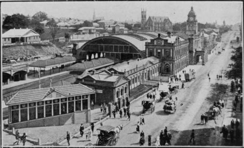
Central railway station is located on the North Coast line in Queensland, Australia. It is the principal station on the City network and is located in the north of the Brisbane central business district. Central station is one of four inner city stations that form a core corridor through the centre of Brisbane. History The first building for Central railway station was a structure of wood and corrugated galvanised iron, and opened on 18 August 1889 as the terminus of the line when it was extended from Roma Street railway station. In 1891, the tunnel to Brunswick Street station (now Fortitude Valley) was opened so trains could run directly from Central to northern destinations. An elegant new station was constructed and opened in 1899 with arches of corrugated galvanised iron over the platforms and a portico on Ann Street. A new entrance with its distinctive row of clocks was constructed in 1901 in sandstone from nearby quarries. In 1904, Central had the only electro-pne ... [...More Info...] [...Related Items...] OR: [Wikipedia] [Google] [Baidu] |
Cross River Rail
Cross River Rail is an underground railway project through central Brisbane, which is, , under construction. Cross River Rail will see the development of a new rail line underneath Brisbane River, and the redevelopment of a number of stations in the Brisbane central business district. The business case for the project was released in August 2017, with construction work officially beginning in September that year. The project replaced the planned 2013 BaT Tunnel, which in turn had replaced the original 2010 Cross River Rail proposal. The project consists of a new 10.2 km line through the CBD from Dutton Park in the city's south to Bowen Hills in the city's north, connecting existing Brisbane rail lines. The project includes 5.9km of twin tunnels and will deliver four new underground stations at Boggo Road, Woolloongabba, Albert Street and Roma Street, with Exhibition station upgraded. Tunnelling for the project was completed in 2021, with construction planned to be complete b ... [...More Info...] [...Related Items...] OR: [Wikipedia] [Google] [Baidu] |
Queensland Rail
Queensland Rail (QR) is a railway operator in Queensland, Australia. Owned by the Queensland Government, it operates local and long-distance passenger services, as well as owning and maintaining approximately 6,600 kilometres of track and related infrastructure. QR was also responsible for all Queensland freight services, and from 2002 operated interstate services under the Australian Railroad Group, Interail and QR National brands. These were all spun out into a separate entity in July 2010, and later privatised as Aurizon. History Beginnings Queensland Railways was the first operator in the world to adopt narrow gauge (in this case ) for a main line, and this remains the systemwide gauge within Queensland today. The colony of Queensland separated from New South Wales in 1859, and the new government was keen to facilitate development and immigration. Improved transport to the fertile Darling Downs region situated west of Toowoomba was seen as a priority. As adequate river ... [...More Info...] [...Related Items...] OR: [Wikipedia] [Google] [Baidu] |
Go Card
The ''go'' card is an electronic smartcard ticketing system developed by Cubic Corporation, which is currently used on the TransLink public transport network in South East Queensland. To use the ''go'' card, users hold the card less than 10 cm away from the reader to "touch on" before starting a journey, and must do the same to "touch off" the service at the end of the journey. The cost of each journey is deducted from the ''go'' card balance. The Queensland Government awarded the $134 million contract to design, build, operate and maintain the ''go'' card system to Cubic Corporation in July 2003. In July 2006, TransLink signed up around 1,000 volunteers to trial the new smartcard system in the Redcliffe area. The go card was launched throughout Brisbane in February 2008, the ''go'' card was available at selected retail stores and Queensland Rail stations. It could also be accessed by phone or online. History The ''go'' card was a major part of the Queensland Governm ... [...More Info...] [...Related Items...] OR: [Wikipedia] [Google] [Baidu] |
Brisbane
Brisbane ( ) is the capital and most populous city of the states and territories of Australia, Australian state of Queensland, and the list of cities in Australia by population, third-most populous city in Australia and Oceania, with a population of approximately 2.6 million. Brisbane lies at the centre of the South East Queensland metropolitan region, which encompasses a population of around 3.8 million. The Brisbane central business district is situated within a peninsula of the Brisbane River about from its mouth at Moreton Bay, a bay of the Coral Sea. Brisbane is located in the hilly floodplain of the Brisbane River Valley between Moreton Bay and the Taylor Range, Taylor and D'Aguilar Range, D'Aguilar mountain ranges. It sprawls across several local government in Australia, local government areas, most centrally the City of Brisbane, Australia's most populous local government area. The demonym of Brisbane is ''Brisbanite''. The Traditional Owners of the Brisbane a ... [...More Info...] [...Related Items...] OR: [Wikipedia] [Google] [Baidu] |
Mixed-use Development
Mixed-use is a kind of urban development, urban design, urban planning and/or a zoning type that blends multiple uses, such as residential, commercial, cultural, institutional, or entertainment, into one space, where those functions are to some degree physically and functionally integrated, and that provides pedestrian connections. Mixed-use development may be applied to a single building, a block or neighborhood, or in zoning policy across an entire city or other administrative unit. These projects may be completed by a private developer, (quasi-) governmental agency, or a combination thereof. A mixed-use development may be a new construction, reuse of an existing building or brownfield site, or a combination. Use in North America vs. Europe Traditionally, human settlements have developed in mixed-use patterns. However, with industrialization, governmental zoning regulations were introduced to separate different functions, such as manufacturing, from residential areas. Public ... [...More Info...] [...Related Items...] OR: [Wikipedia] [Google] [Baidu] |
Park Road Railway Station
Park Road railway station is the junction station for the Gold Coast and Cleveland lines in Queensland, Australia. It serves the Brisbane suburb of Woolloongabba. It is served by Beenleigh, Cleveland and Gold Coast line services. Immediately south of the station lies a triangle junction with the Cleveland and Fisherman Islands lines branching off. History In September 1930, the standard gauge NSW North Coast line opened to the west of the station. On 12 November 1942, a wartime siding opened at Park Road, followed by a second on 28 February 1944. After falling out of use in 1945, the yard was reactivated in 1949. In its later years, it was primarily used by paper trains for Queensland Newspapers. It closed again in the early 1990s. As part of the construction of the Gold Coast line, the standard gauge line was converted to dual gauge to allow these services to be segregated from Beenleigh and Cleveland services. In 2000, a project commenced to add a fourth track and platfor ... [...More Info...] [...Related Items...] OR: [Wikipedia] [Google] [Baidu] |
Boggo Road Busway Station
Boggo Road busway station is located in Brisbane, Australia serving the suburb of Dutton Park. It opened on 3 August 2009, as part of the Eastern Busway from UQ Lakes to Buranda. The busway platforms at Boggo Road are numbered 5 and 6 to align with the platforms at the adjacent Park Road railway station. Transport links Brisbane Transport operate seven routes via Boggo Road busway station: * 29: UQ Lakes to Woolloongabba * 66: UQ Lakes to RBWH station via Brisbane City * 104: Corinda station to PA Hospital * 105: Indooroopilly to Brisbane City via Yeronga * 139: UQ Lakes to Sunnybank Hills * 169: UQ Lakes to Eight Mile Plains station * 209: UQ Lakes to Westfield Carindale Future Boggo Road railway station, part of the Cross River Rail Cross River Rail is an underground railway project through central Brisbane, which is, , under construction. Cross River Rail will see the development of a new rail line underneath Brisbane River, and the redevelopment of a numb ... [...More Info...] [...Related Items...] OR: [Wikipedia] [Google] [Baidu] |
Railway Gazette International
''Railway Gazette International'' is a monthly business magazine and news website covering the railway, metro, light rail and tram industries worldwide. Available by annual subscription, the magazine is read in over 140 countries by transport professionals and decision makers, railway managers, engineers, consultants and suppliers to the rail industry. A mix of technical, commercial and geographical feature articles, plus the regular monthly news pages, cover developments in all aspects of the rail industry, including infrastructure, operations, rolling stock and signalling. History ''Railway Gazette International'' traces its history to May 1835 as ''The Railway Magazine'', when it was founded by Effingham Wilson. The ''Railway Gazette'' title dates from July 1905, created to cover railway commercial and financial affairs. In April 1914 it merged with ''The Railway Times'', which incorporated '' Herapath's Railway Journal'', and in February 1935 it absorbed the ''Railway Engine ... [...More Info...] [...Related Items...] OR: [Wikipedia] [Google] [Baidu] |
Princess Alexandra Hospital, Brisbane
The Princess Alexandra Hospital (PAH) is a major Australian teaching hospital of the University of Queensland, located in Brisbane, Queensland. It is a tertiary level teaching hospital with all major medical and surgical specialities onsite except for obstetrics, gynaecology, paediatrics, and medical genetics. It has a catchment population of 1.6 million people with 1038 beds and 5,800 full-time equivalent staff. In 2005, the hospital received Magnet Recognition. The hospital is located on Ipswich Road in Woolloongabba, an inner-city suburb of Brisbane. History The hospital is built on the site of the 1883 Diamantina Orphanage, named after Diamantina Bowen, wife of the first Governor of Queensland. In 1901, it became Diamantina Hospital for Chronic Diseases. In 1943, it became the South Brisbane Auxiliary Hospital and then the South Brisbane Hospital in 1956. In 1959, it became the Princess Alexandra Hospital and was opened by and named after HRH Princess Alexandra, to ... [...More Info...] [...Related Items...] OR: [Wikipedia] [Google] [Baidu] |
Woolloongabba Railway Station
Woolloongabba railway station is a railway station currently under construction as part of the Cross River Rail project in the Brisbane suburb of Woolloongabba. To be built as an underground station beneath The Gabba, it will consist of two platforms with a connection to Woolloongabba busway station. Cross River Rail Construction commenced in November 2019, with it scheduled to open in 2026. The platforms are built at a depth of 27 metres. Their length is 220 metres. Construction The station is built using a full cavern construction method. It was important to design lifts and elevators that can handle the expected surge capacity during large sports events at the nearby Gabba. Similar to |


.jpg)
