|
Bagno Di Gavorrano
Bagno di Gavorrano is a small town in Tuscany, central Italy, administratively a frazione of the comune of Gavorrano, province of Grosseto. At the time of the 2001 census its population amounted to . Geography Bagno is about 35 km from Grosseto and 3 km from Gavorrano, and it is situated in the plain below the hill of Monte d'Alma, next to the Via Aurelia highway. Bagno, which means ''bath'', was a thermal village until the 1950s. Main sights * ''San Giuseppe Lavoratore'' (20th century), main parish church of the village, it was designed by engineer Ernesto Ganelli and consecrated in 1957.Bruno Santi, ''Guida storico-artistica alla Maremma. Itinerari culturali nella provincia di Grosseto'', Nuova Immagine, Siena, 1995, p. 69. Sports The Stadio Romeo Malservisi, which hosts the games of local soccer team U.S. Gavorrano, is situated in Bagno. References Bibliography * Bernardino Lotti, ''La sorgente termale del Bagno di Gavorrano in provincia di Grosseto'', ... [...More Info...] [...Related Items...] OR: [Wikipedia] [Google] [Baidu] |
Province Of Grosseto
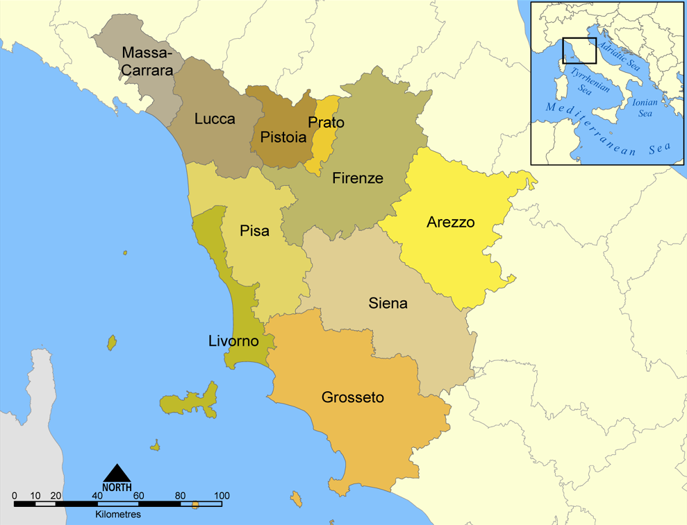
The province of Grosseto ( it, links=no, provincia di Grosseto) is a province in the Tuscany region of Italy. Its capital is the city of Grosseto. As of 2013 the province had a total population of 225,098 people. Geography The Province of Grosseto completely occupies the southern end of Tuscany, and with a territorial area of , it is the most extensive in the region and one of the least dense in population in Italy. The province is bordered to the northwest by the Province of Livorno, to the north by the Province of Pisa, to the northeast by the Province of Siena, and to the southeast by the Province of Viterbo in Lazio. To the south is the Tyrrhenian Sea, which includes the southern islands of the Tuscan archipelago, including Isola del Giglio and the smaller Giannutri islands and Formiche di Grosseto and Formica di Burano. The Arcipelago Toscano National Park spans both the provinces of Grosseto and Livorno, and includes the seven main islands of the Tuscan Archipelago: Elba ... [...More Info...] [...Related Items...] OR: [Wikipedia] [Google] [Baidu] |
Stadio Romeo Malservisi
Stadio Romeo Malservisi is a multi-use stadium in Gavorrano, Italy. It is currently used mostly for football matches and is the home ground of U.S. Gavorrano Unione Sportiva Follonica Gavorrano is an Italian association football club that represents the municipalities of Follonica and Gavorrano in Tuscany, the latter is also the company headquarters. The club currently play in Serie D, the fourth t .... The stadium holds 2,000. Gallery File:GavorranoBagnoStadioRomeoMalservisi1.JPG, Stadium entry File:GavorranoBagnoStadioRomeoMalservisi2.JPG, Stadium panorama File:GavorranoBagnoStadioRomeoMalservisi6.JPG, End Stand External linksStadio Romeo Malservisiat Soccerway.com Romeo Malservisi Sports venues in Tuscany Gavorrano {{Italy-sports-venue-stub ... [...More Info...] [...Related Items...] OR: [Wikipedia] [Google] [Baidu] |
Potassa, Gavorrano
Potassa is a village in Tuscany, central Italy, administratively a frazione of the comune of Gavorrano, province of Grosseto. At the time of the 2001 census its population amounted to 160. Geography Potassa is about 30 km from Grosseto and 7 km from Gavorrano, and it is situated in a plain at the foot of the hills of Monte Calvo and Poggio Moscatello, down the ravine Sovata. History Potassa was born in the 19th century as an industrial centre related to the mines of Gavorrano. Its name comes from potassium carbonate (''potassa'' in Italian).Alberto Prunetti, ''Potassa'', Viterbo, Stampa Alternativa, 2004. Transportation The village is positioned along the Via Aurelia The ''Via Aurelia'' (Latin for "Aurelian Way") is a Roman road in Italy constructed in approximately 241 BC. The project was undertaken by Gaius Aurelius Cotta, who at that time was censor.Hornblower, Simon, & Antony Spawforth. ''The Oxford Cl ... highway and easily reached from the Tirrenica ra ... [...More Info...] [...Related Items...] OR: [Wikipedia] [Google] [Baidu] |
Grilli, Gavorrano
Grilli is a village in Tuscany, central Italy, administratively a frazione of the comune of Gavorrano, province of Grosseto. At the time of the 2001 census its population amounted to 268. Grilli is about 25 km from Grosseto and 10 km from Gavorrano, and it is situated in a plain between the hills of Giuncarico, Caldana and Vetulonia. The village was born in the 19th century as an industrial centre related to the mines of Gavorrano. Main sights * Church of ''Santa Rita da Cascia'', main church of the village, it was built in 1969. * Farm of ''Lupo'' (19th century), old estate with a manor house, a chapel, a clock tower, a well and a guard shed (''casello idraulico'') for the water control. , Soprintendenza per i Beni Architettonici e per il Paesaggio per le province di Siena e Grosseto, official si ... [...More Info...] [...Related Items...] OR: [Wikipedia] [Google] [Baidu] |
Giuncarico
Giuncarico is a village in Tuscany, central Italy, administratively a frazione of the comune of Gavorrano, province of Grosseto. At the time of the 2001 census its population amounted to 399. History The village dates back to the Early Middle Ages, when it was a property of the Aldobrandeschi family and then of the Pannocchieschi. It was then conquered by the Republic of Siena during the 14th century. Main sights Churches * ''Sant'Egidio'' (13th century), main parish church of the village, it was restructured in 1930 and then renewed in 1960.Bruno Santi, ''Guida storico-artistica alla Maremma. Itinerari culturali nella provincia di Grosseto'', Nuova Immagine, Siena, 1995, pp. 72-73. * Oratory of ''Santissimo Crocifisso'' (19th century), situated outside the city walls, it was built in 1892. * Hermitage of ''Sant'Ansano'' (17th century), it's now in ruins. [...More Info...] [...Related Items...] OR: [Wikipedia] [Google] [Baidu] |
Filare
Filare is a village in Tuscany, central Italy, administratively a frazione of the comune of Gavorrano, province of Grosseto. At the time of the 2001 census its population amounted to 439. . Filare is about 35 km from and 2 km from ... [...More Info...] [...Related Items...] OR: [Wikipedia] [Google] [Baidu] |
Castellaccia
Castellaccia is a village in Tuscany, central Italy, administratively a frazione of the comune of Gavorrano, province of Grosseto. At the time of the 2001 census its population amounted to 79. Castellaccia is about 22 km from Grosseto and 15 km from Gavorrano, and it is situated in the plain below the hill of Giuncarico, along the road to the town of Ribolla. The centre of the village is the court of the old Farm of Castellaccia. Main sights * Chapel of ''Sant'Oliva'', little church situated next to the main villa of the old farm. * Villa Benini, manor house of the Farm of Castellaccia, it was restructured in 1910. * Poggio Pelliccia: located in the countryside near the village, it's an ancient archeological site with a monumental Etruscan tomb, dating back to the 7th century BC, probably burial of an aristocratic family from the nearby Vetulonia. [...More Info...] [...Related Items...] OR: [Wikipedia] [Google] [Baidu] |
Caldana
Caldana is a village in Tuscany, central Italy, administratively a frazione of the comune of Gavorrano, province of Grosseto. At the time of the 2001 census its population amounted to 980. Geography Caldana is about 28 km from Grosseto and 8 km from Gavorrano, and it is situated on a hill in the south-eastern side of the massif of Monte Calvo. History The village dates back to the Early Middle Ages, when it was a property of the bishops of Roselle. It was then ruled by the Pannocchieschi family and conquered by the Republic of Siena during the 14th century. Main sights * ''San Biagio'' (16th century), main parish church of the village, it is attributed to Renaissance architect Antonio da Sangallo the Elder. The bell tower was built in 1828. Inside the church there is a fresco by Giuseppe Nicola Nasini.Bruno Santi, ''Guida storico-artistica alla Maremma. Itinerari culturali nella provincia di Grosseto'', Nuova Immagine, Siena, 1995, pp. 69-71. * Canonica of ''Sa ... [...More Info...] [...Related Items...] OR: [Wikipedia] [Google] [Baidu] |
Soccer
Association football, more commonly known as football or soccer, is a team sport played between two teams of 11 players who primarily use their feet to propel the ball around a rectangular field called a pitch. The objective of the game is to score more goals than the opposition by moving the ball beyond the goal line into a rectangular framed goal defended by the opposing side. Traditionally, the game has been played over two 45 minute halves, for a total match time of 90 minutes. With an estimated 250 million players active in over 200 countries, it is considered the world's most popular sport. The game of association football is played in accordance with the Laws of the Game, a set of rules that has been in effect since 1863 with the International Football Association Board (IFAB) maintaining them since 1886. The game is played with a football that is in circumference. The two teams compete to get the ball into the other team's goal (between the posts and under t ... [...More Info...] [...Related Items...] OR: [Wikipedia] [Google] [Baidu] |
Ernesto Ganelli
Ernesto Ganelli (24 February 1901 – 9 September 1985) was an Italian civil engineer who designed various public and religious buildings in Tuscany. Biography Born in Alessandria, Ganelli graduated in civil engineering at the Sapienza University of Rome in 1924. He moved to Grosseto, Tuscany, where he became one of the most influential civil engineers and architects of that city. In his career he designed hundreds of public, religious and private buildings in southern Tuscany, and he designed almost all of the churches built in the dioceses of Grosseto and Pitigliano-Sovana-Orbetello during the 20th century. Works (selection) * Palazzo ONMI (1933–1934) in Grosseto * Elementary School (1934) in Sassofortino * Restoration of Palazzo Stella d'Italia (1934) in Grosseto * Episcopal Seminary (1934–1936) in Grosseto * Church of ''San Giuseppe'' (1935–1940) in Grosseto * Church of ''San Guglielmo d'Aquitania'' (1935–1940) in Braccagni * Clergy house of the Grosseto Cathedra ... [...More Info...] [...Related Items...] OR: [Wikipedia] [Google] [Baidu] |
Gavorrano
Gavorrano is a mountain-side ''comune'' (municipality) in the Province of Grosseto in the western Italian region of Tuscany, located about 100 km (62 mi) southwest of Florence and about 25 km (16 mi) northwest of Grosseto. Gavorrano borders the municipalities of Castiglione della Pescaia, Grosseto, Massa Marittima, Roccastrada and Scarlino. The village is located on the northern slope of Poggio Ballone, east of Scarlino, in an area extremely rich in terms of mining, especially for large deposits of the iron ore pyrite which were intensively exploited until the early 1980s. The town is known because of Pia de' Tolomei (whose fate is related in the "Purgatory" cantoes of the ''Divine Comedy'' by Dante Alighieri), and for being the birthplace of the writer Giuseppe Bandi, Italian patriot and journalist. History The Etruscan territory of Gavorrano fell under the direct control of Vetulonia which, through the paths along the river valleys of Sovata and Bruna, w ... [...More Info...] [...Related Items...] OR: [Wikipedia] [Google] [Baidu] |
Via Aurelia
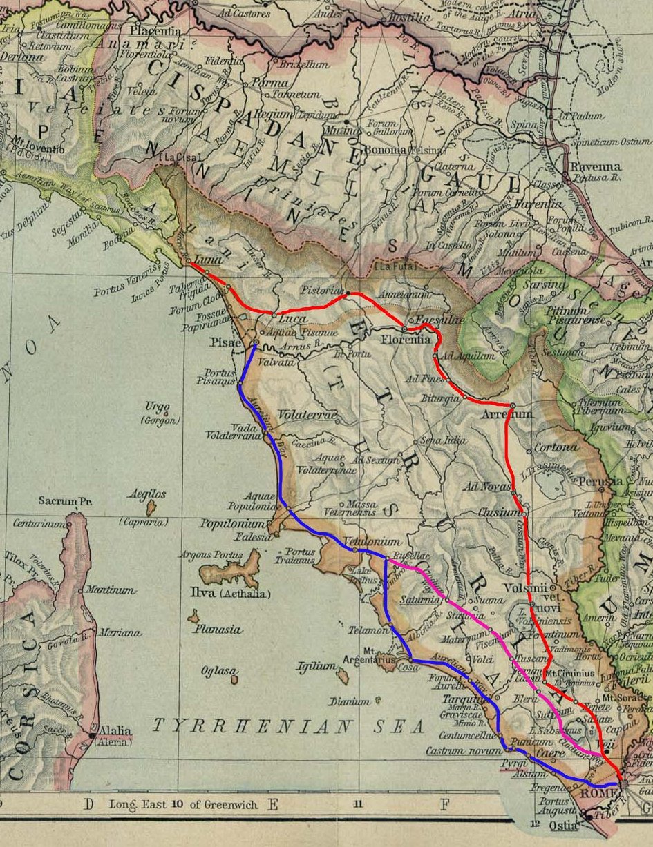
The ''Via Aurelia'' (Latin for "Aurelian Way") is a Roman road in Italy constructed in approximately 241 BC. The project was undertaken by Gaius Aurelius Cotta, who at that time was censor.Hornblower, Simon, & Antony Spawforth. ''The Oxford Classical Dictionary.'' 3rd ed. Oxford: Oxford University Press, 1996. Cotta had a history of building roads for Rome, as he had overseen the construction of a military road in Sicily (as consul in 252 BC, during the First Punic War) connecting ''Agrigentum'' (modern Agrigento) and ''Panormus'' (modern Palermo). Background In the middle Republic, a series of roads were built throughout Italy to serve the needs of Roman expansion, including swift army movements and reasonably quick communication with Roman colonies spread throughout Italy. There also was the unintended (but beneficial) consequence of an increase in trade among Italian cities and with Rome. The roads were standardized to wide allowing two chariots to pass, and distance was ma ... [...More Info...] [...Related Items...] OR: [Wikipedia] [Google] [Baidu] |


