|
Australasian Bittern
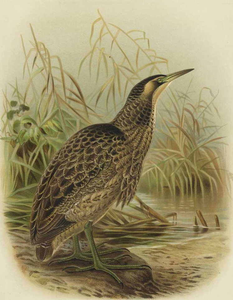
The Australasian bittern (''Botaurus poiciloptilus''), also known as the brown bittern or matuku hūrepo, and also nicknamed the "bunyip bird", is a large bird in the heron family Ardeidae. A secretive bird with a distinctive booming call, it is more often heard than seen. Australasian bitterns are endangered in both Australia and New Zealand. Taxonomy German zoologist Johann Georg Wagler described the Australasian bittern in 1827. It is one of four similarly-plumaged species in the genus ''Botaurus''. Description The length is from 650 to 750 mm with adults being similar between the sexes while the male is significantly larger. The bird has a deep brown upper surface, mauled with buff on wing coverts; face and eyebrow buff, with dark brown stripe running from bill to erectile plumes at sides of neck. Under surface buff, striped with brown. The face skin is a dull green as are the legs and feet, it possesses a dark brown bill, yellow eyes, and the base of the lower mandible is gr ... [...More Info...] [...Related Items...] OR: [Wikipedia] [Google] [Baidu] |
Walter Lawry Buller
Sir Walter Lawry Buller (9 October 1838 – 19 July 1906) was a New Zealand lawyer and natural history, naturalist who was a dominant figure in New Zealand ornithology. His book, ''A History of the Birds of New Zealand'', first published in 1873, was published as an enlarged version in 1888 and became a New Zealand classic. Biography Buller was born at Newark, the Wesleyan mission at Pakanae in the Hokianga, the son of Rev. James Buller, a Cornish people, Cornish missionary who had helped convert the people of Tonga to Methodism. He was educated at Wesley College, Auckland, Wesley College in Auckland. In 1854, he moved to Wellington with his parents, where he was befriended by the naturalist William John Swainson. In 1859 he was made Native Commissioner for the Southern Provinces. In 1871 he travelled to England and was called to the bar at the Inner Temple. Three years later he returned to Wellington and practised law. In 1862, he married Charlotte Mair at Whangārei. They we ... [...More Info...] [...Related Items...] OR: [Wikipedia] [Google] [Baidu] |
Endangered
An endangered species is a species that is very likely to become extinct in the near future, either worldwide or in a particular political jurisdiction. Endangered species may be at risk due to factors such as habitat loss, poaching and invasive species. The International Union for Conservation of Nature (IUCN) Red List lists the global conservation status of many species, and various other agencies assess the status of species within particular areas. Many nations have laws that protect conservation-reliant species which, for example, forbid hunting, restrict land development, or create protected areas. Some endangered species are the target of extensive conservation efforts such as captive breeding and habitat restoration. Human activity is a significant cause in causing some species to become endangered. Conservation status The conservation status of a species indicates the likelihood that it will become extinct. Multiple factors are considered when assessing the s ... [...More Info...] [...Related Items...] OR: [Wikipedia] [Google] [Baidu] |
Edithvale-Seaford Wetlands
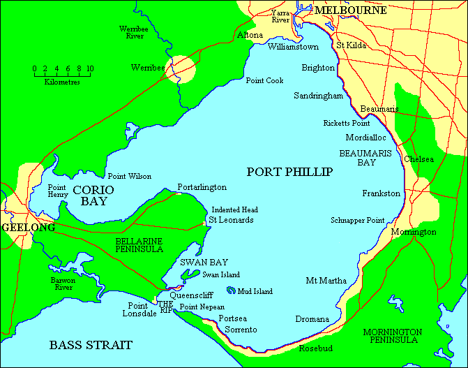
The Edithvale-Seaford Wetlands is a collection of principally freshwater swamps and marshlands totalling in southeastern Melbourne, Victoria, Australia, about southeast of Melbourne CBD. It is the largest natural wetland of its type in the Port Phillip and Western Port basins, and is all that remains of the historic Carrum Carrum Swamp, which once covered more than from present-day Mordialloc in the north to Frankston in the south. The surviving wetlands are divided into two groups, namely the northern Edithvale Wetlands ( in total) and the southern Seaford Wetlands ( in total), which together form the Edithvale-Seaford Wetlands Ramsar Site. Along with the nearby Eastern Treatment Plant, they form the Carrum Wetlands Important Bird Area. All the wetlands are no more than away from the shore of Beaumaris Bay, bounded by Governor Road in the north, the coastal Nepean Highway in the west, the Mornington Peninsula Freeway and Frankston Freeway in the east, and Seaford Road ... [...More Info...] [...Related Items...] OR: [Wikipedia] [Google] [Baidu] |
Bellarine Wetlands Important Bird Area
The Bellarine Wetlands Important Bird Area comprises a group of wetland sites, with a collective area of 46 km2, at the western end of the Bellarine Peninsula in Victoria, south-eastern Australia. The site is important for waterbirds and orange-bellied parrots. Description The wetlands include the Moolap saltworks, with the adjacent intertidal mudflats of Point Henry and Corio Bay, and the extensive wetlands of Reedy Lake, Hospital Swamp and Lake Connewarre. Reedy Lake is contiguous with Hospital Swamp, Lake Connewarre, Salt Swamp, Murtnaghurt Lagoon and the Barwon River estuary. Moolap is a commercial saltworks and much of Point Henry is occupied by an aluminum smelter; the other wetlands are state game reserves. Reedy Lake is freshwater; Moolap, Hospital Swamp and Connewarre are saline. The Reedy Lake - Lake Connewarre system is part of the Port Phillip and Bellarine Peninsula Ramsar site. Birds The wetlands have been identified as an Important Bird Area (IBA) ... [...More Info...] [...Related Items...] OR: [Wikipedia] [Google] [Baidu] |
Barmah-Millewa Important Bird Area
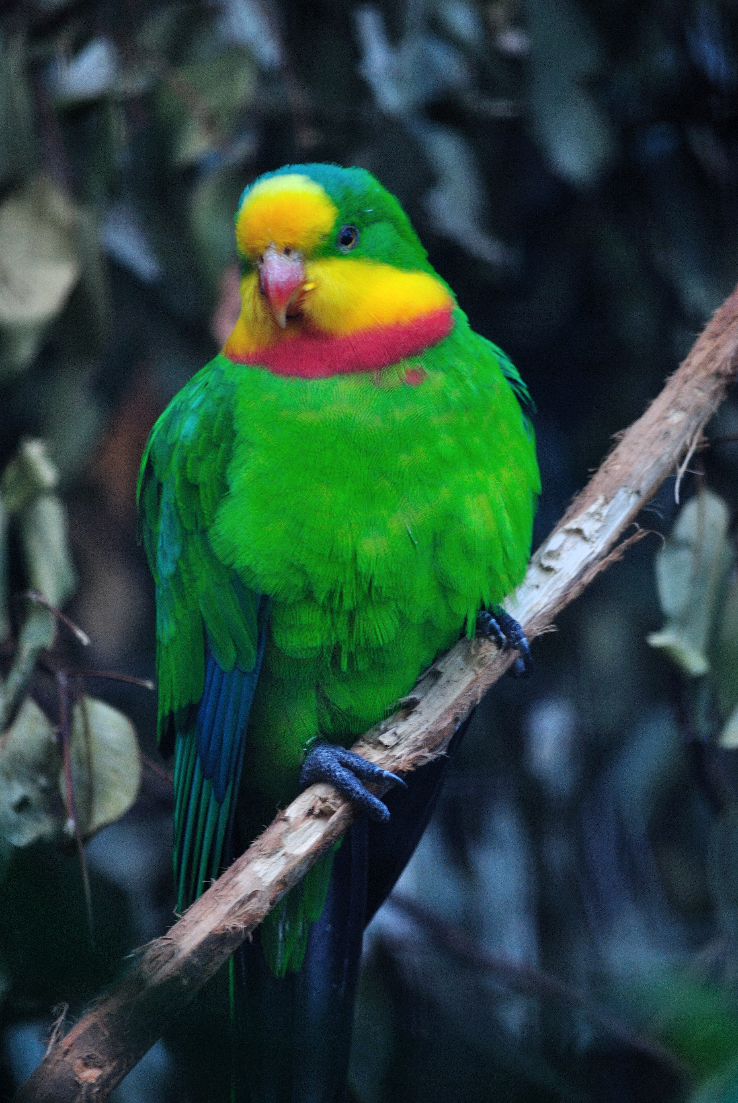
The Barmah-Millewa Important Bird Area is a 2635 km2 tract of land in south-eastern Australia which has been identified by BirdLife International as an Important Bird Area (IBA) because of its significance for the conservation of a range of bird species. Description The site straddles the upper Murray River and the border between the states of New South Wales and Victoria. It contains, and is largely defined by, Australia's largest remaining river red gum forest and includes the Barmah National Park in Victoria as well as several state forests in New South Wales. It includes agricultural land within 10 km foraging range of superb parrot forest breeding habitat. Birds The site was identified as an IBA because it supports Australasian bitterns, superb parrots, flame robins and diamond firetails, as well as large numbers of breeding waterbird A water bird, alternatively waterbird or aquatic bird, is a bird that lives on or around water. In some definitions, the ... [...More Info...] [...Related Items...] OR: [Wikipedia] [Google] [Baidu] |
Egg Islands
The Egg Islands are a small group of low-lying estuarine islands in the tidal lower reaches of the Huon River of south-east Tasmania, Australia. They face the town of Franklin which lies on the western bank of the river. Birds The islands have been identified as a 317 ha Important Bird Area because they support a small population of the Australasian bittern, one of the last refuges for this endangered species in the state. Swift parrots occasionally visit the islands which are also home to large numbers of the endemic Tasmanian nativehens and yellow wattlebird The yellow wattlebird (''Anthochaera paradoxa'') is a species of bird in the honeyeater family Meliphagidae. Other names include the long wattlebird or Tasmanian wattlebird. Taxonomy French zoologist François Marie Daudin described the yellow w ...s. References Important Bird Areas of Tasmania Islands of South East Tasmania Southern Tasmania {{Tasmania-geo-stub ... [...More Info...] [...Related Items...] OR: [Wikipedia] [Google] [Baidu] |
Narran Wetlands
The Narran Wetlands, also known as the Narran Lakes, contained within the Narran Lake Nature Reserve, comprise a series of protected ephemeral lakes and swamps fed by the Narran River in the north-west of New South Wales, Australia. The reserve is located approximately east of . An area contained within the reserve is protected under the Ramsar Convention as a wetland of international importance. It is internationally important because of its rarity and naturalness; its significance for waterbirds, supporting large colonial waterbird breeding events of ibis, spoonbills and cormorants; and its importance as a drought refuge for waterbirds. The vegetation and the waterbird colonies are at risk from reduced flooding caused by upstream water abstraction for agriculture in Queensland. Description The wetland complex formed by the Narran floodplain is the terminal system of the Narran River, the easternmost distributary of the Balonne River, and lies between the towns of Brewarrina ... [...More Info...] [...Related Items...] OR: [Wikipedia] [Google] [Baidu] |
Macquarie Marshes
The Macquarie Marshes comprise the wetlands associated with the floodplains of the Macquarie River and its tributaries, in northern New South Wales, Australia. The Macquarie River and the marshes eventually drain into the Darling River. The marshes are important as a breeding site for waterbirds, especially in the aftermath of major floods. Description The marshes consist of a system of freshwater channels and streams, some of which are permanent following construction of water regulation devices, with semi-permanent and ephemeral swamps and floodplains. The extent of the marshes varies according to the extent of flooding. The historical maximum flooding of was recorded in the mid-1950s; since then flooding has become both less frequent and less extensive. Most of the area covered by the marshes is used as rangeland or pasture; some 10% is protected in the Macquarie Marshes Nature Reserve. Among the variety of vegetation types supported by the marshes are river red gum fo ... [...More Info...] [...Related Items...] OR: [Wikipedia] [Google] [Baidu] |
Hunter Estuary Wetlands
The Hunter Estuary Wetlands comprise a group of associated wetlands at and near the mouth of the Hunter River in the city of Newcastle, New South Wales, Australia. Some 30 km2 of the wetlands has been recognised as being of international importance by designation under the Ramsar Convention. It was listed on 21 February 1984 as Ramsar site 287. A larger area of the wetlands has been identified by BirdLife International as an Important Bird Area (IBA). The wetlands are recognised as the most important area in New South Wales for waders, or shorebirds. Description Ramsar site The Ramsar site comprises the Kooragang Nature Reserve and the nearby Shortland Wetlands, which are connected by a wildlife corridor that includes the Hunter River and Ironbark Creek. Kooragang Island is an artificial, estuarine island liable to flooding at high tide. Its habitats include mangroves, brackish and freshwater swamps, saltmarsh, ''Casuarina'' forest, mudflats, beaches and rock walls. T ... [...More Info...] [...Related Items...] OR: [Wikipedia] [Google] [Baidu] |
Hastings-Macleay Important Bird Area
The Hastings-Macleay Important Bird Area is a 1148 km2 tract of land stretching for 100 km along the Mid North Coast of New South Wales, Australia, from Stuarts Point in the north to the Camden Haven River in the south. It is bounded on the west by the Pacific Highway. It combines ephemeral floodplain wetlands with coastal swamp forests. It is mostly cattle-grazed but contains large blocks of state forest, protected areas and tea-tree plantations. Birds The land was identified by BirdLife International as an IBA because it regularly supports significant numbers of the endangered swift parrot, regent honeyeater and Australasian bittern, and probably over 1% of the world population of sharp-tailed sandpiper The sharp-tailed sandpiper (''Calidris acuminata'') (but see below) is a small wader. Taxonomy A review of data has indicated that this bird should perhaps better be placed into the genus ''Philomachus'' – as ''P. acuminatus'' – which now ...s. Refe ... [...More Info...] [...Related Items...] OR: [Wikipedia] [Google] [Baidu] |
Gwydir Wetlands
The Gwydir Wetlands comprise a system of irregularly inundated wetlands associated with the Gwydir River in the North West Slopes region of north-eastern New South Wales, Australia. When flooded they form an important site for breeding waterbirds. Description The wetlands lie between the towns of Moree and Mungindi in the Moree Plains Shire near the state border with Queensland. They consist of the inland floodplain of the Gwydir River that splits into the Gingham and Big Leather water courses and creating, when fully flooded, a 1021 km2 wetland some 45 km west of Moree. The extensive wetland area is a good example of an inland terminal delta. The floodwater extends for about 95 km through a series of natural and constructed channels and swamps. Once a closed system, since the building of the 1364 GL Copeton Dam, water flows have been controlled by the State Government water authorities to the detriment of the wetlands. Despite the consequent reducti ... [...More Info...] [...Related Items...] OR: [Wikipedia] [Google] [Baidu] |
Griffith Wetlands Important Bird Area
The Griffith Wetlands Important Bird Area is a group of wetlands lying close to the Riverina town of Griffith in southern New South Wales, Australia. It lies within the Murrumbidgee Irrigation Area. Description North and South Lake Wyangan are used for water storage; they contain an area of cumbungi. Nericon Swamp is a shallow swamp usually dry enough to be grazed by cattle, though it sometimes fills from local rains when it supports large numbers of waders. Barren Box Swamp was originally an ephemeral swamp; it has been divided into three parts, with 60% of it remaining a natural wetland which holds water only in wet years; the other 40% is used for water storage and recycling, with reed beds and grazed margins. Campbell's Swamp is a black box- lignum swamp containing extensive open areas punctuated by stands of reeds and cumbungi; it fills occasionally from local rainfall or with water released from the irrigation system. Birds Together, the wetlands have been identified ... [...More Info...] [...Related Items...] OR: [Wikipedia] [Google] [Baidu] |
_(cropped).jpg)


