|
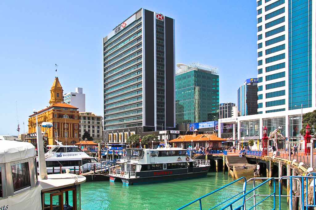
Auckland Waterfront
The Auckland waterfront (rarely the Auckland harbourfront) is a city-side stretch of the southern Waitematā Harbour coastline in Auckland, New Zealand. Previously mostly dominated by Ports of Auckland uses, from the 2000s on it is becoming increasingly open to recreational public use, with a number of former wharves being converted to office, entertainment, and later also some residential uses. Extents The waterfront stretches roughly from the suburb of Saint Marys Bay / the Auckland Harbour Bridge in the west to the Ports of Auckland areas in the east. However, in most usage, 'Auckland waterfront' only refers to those parts freely accessible to the public (such as around the Viaduct Basin and the Auckland CBD), and thus at the moment excludes much of the Western Reclamation and almost the whole of the Ports of Auckland area to the east. While Auckland City technically has a second waterfront on the Manukau Harbour, this is never called 'Auckland waterfront'. Future During ... [...More Info...] [...Related Items...] OR: [Wikipedia] [Google] [Baidu] |
Leasing
A lease is a contractual arrangement calling for the user (referred to as the ''lessee'') to pay the owner (referred to as the ''lessor'') for the use of an asset. Property, buildings and vehicles are common assets that are leased. Industrial or business equipment are also leased. Basically a lease agreement is a contract between two parties: the lessor and the lessee. The lessor is the legal owner of the asset, while the lessee obtains the right to use the asset in return for regular rental payments. The lessee also agrees to abide by various conditions regarding their use of the property or equipment. For example, a person leasing a car may agree to the condition that the car will only be used for personal use. The term rental agreement can refer to two kinds of leases: * A lease in which the asset is tangible property. Here, the user '' rents'' the asset (e.g. land or goods) ''let out'' or ''rented out'' by the owner (the verb ''to lease'' is less precise because it can ... [...More Info...] [...Related Items...] OR: [Wikipedia] [Google] [Baidu] |
Mechanics Bay
Mechanics Bay ( mi, Te Tōangaroa) is a reclaimed bay on the Waitematā Harbour in Auckland, New Zealand. It is also the name of the area of the former bay that is now mainly occupied by commercial and port facilities. Sometimes the bay formed between Tamaki Drive and the western reclamation edge of Fergusson Container Terminal is also referred to as Mechanics Bay. History The bay was called Te Tōangaroa by Tāmaki Māori, referring to the need to drag waka a long distance during low tide in the bay. During the early colonial era of Auckland, Mechanics Bay was the main trading port on the Waitematā Harbour for Māori, in a separate location from the main Auckland waterfront. European settlement Along the harbour shore between Point Britomart and St Stephen's Point in Parnell were four bays: Official Bay, Mechanics Bay, St Georges Bay and Judges Bay. Some have now disappeared due to land reclamation and the quarrying of the bordering headlands. Closest to Point Britomar ... [...More Info...] [...Related Items...] OR: [Wikipedia] [Google] [Baidu] |
Freemans Bay
Freemans Bay is the name of a former bay and now inner city suburb of Auckland, in the North Island of New Zealand. The bay has been filled in to a considerable extent, with the reclamation area now totally concealing the ancient shoreline. Historically a poor and often disreputable quarter, it is now a comparatively wealthy and desirable neighbourhood known for its mix of heritage homes and more recent single-dwelling houses, as well as for its two large parks. Demographics Freemans Bay covers and had an estimated population of as of with a population density of people per km2. Freemans Bay had a population of 4,407 at the 2018 New Zealand census, an increase of 201 people (4.8%) since the 2013 census, and an increase of 576 people (15.0%) since the 2006 census. There were 1,920 households, comprising 2,196 males and 2,208 females, giving a sex ratio of 0.99 males per female. The median age was 36.9 years (compared with 37.4 years nationally), with 399 people (9.1%) aged ... [...More Info...] [...Related Items...] OR: [Wikipedia] [Google] [Baidu] |
Commercial Bay dividing it from Official Bay and Mechanics Bay in the east. Commercial Bay ( mi, Onepanea) was a bay on the southern side of the Waitematā Harbour that defined the original extent of the Auckland waterfront in Auckland, New Zealand. It was framed by two substantial headlands, Smale's Point dividing it from Freemans Bay in the west and Point Britomart Point Britomart ( mi, Te Rerenga Ora Iti) was a headland in the Waitematā Harbour, in Auckland (), New Zealand. Located between Commercial Bay and Official Bay, [...More Info...] [...Related Items...] OR: [Wikipedia] [Google] [Baidu] |
PricewaterhouseCoopers
PricewaterhouseCoopers is an international professional services brand of firms, operating as partnerships under the PwC brand. It is the second-largest professional services network in the world and is considered one of the Big Four accounting firms, along with Deloitte, EY and KPMG. PwC firms are in 157 countries, across 742 locations, with 284,000 people. As of 2019, 26% of the workforce was based in the Americas, 26% in Asia, 32% in Western Europe and 5% in Middle East and Africa. The company's global revenues were $42.4 billion in FY 2019, of which $17.4 billion was generated by its Assurance practice, $10.7 billion by its Tax and Legal practice and $14.4 billion by its Advisory practice. The firm in its recent actual form was created in 1998 by a merger between two accounting firms: Coopers & Lybrand, and Price Waterhouse. Both firms had histories dating back to the 19th century. The trading name was shortened to PwC (stylized p''w''c) in September 2010 as part o ... [...More Info...] [...Related Items...] OR: [Wikipedia] [Google] [Baidu] |
Princes Wharf
Prince's Wharf, or Princes Wharf, may refer to: * Princes Wharf, Auckland, a wharf in Auckland Harbour, Auckland, New Zealand * Prince's Wharf, Bristol, a wharf in Bristol Harbour, Bristol, England {{disambig ... [...More Info...] [...Related Items...] OR: [Wikipedia] [Google] [Baidu] |
Cruise Ship
Cruise ships are large passenger ships used mainly for vacationing. Unlike ocean liners, which are used for transport, cruise ships typically embark on round-trip voyages to various ports-of-call, where passengers may go on Tourism, tours known as "shore excursions". On "cruises to nowhere" or "nowhere voyages", cruise ships make two- to three-night round trips without visiting any ports of call.Compare: Modern cruise ships tend to have less hull strength, speed, and agility compared to ocean liners. However, they have added amenities to cater to water tourism, water tourists, with recent vessels being described as "balcony-laden floating condominiums". As of December 2018, there were 314 cruise ships operating worldwide, with a combined capacity of 537,000 passengers. Cruising has become a major part of the tourism industry, with an estimated market of $29.4 billion per year, and over 19 million passengers carried worldwide annually . The industry's rapid growth ... [...More Info...] [...Related Items...] OR: [Wikipedia] [Google] [Baidu] |
Ministry Of Agriculture And Forestry (New Zealand)
The Ministry of Agriculture and Forestry (in Māori, ''Te Manatu Ahuwhenua, Ngāherehere'') was a state sector organisation of New Zealand which dealt with matters relating to agriculture, forestry and biosecurity. It was commonly known by its acronym, "MAF". In April 2012, it became part of the newly formed Ministry for Primary Industries. History The New Zealand Ministry of Agriculture and Forestry was formerly known as the ''Ministry of Agriculture and Fisheries'', but in 1995 responsibilities for fisheries were passed to the newly formed Ministry of Fisheries. However, the government of New Zealand decided that, despite the loss of Fisheries, the newly created ''Ministry of Agriculture'' should continue to be known by the acronym "MAF", and should still use the same logo, because of the high recognition and regard for the name and logo amongst the country's overseas trading partners. In 1998, this Ministry of Agriculture and the Ministry of Forestry merged to become th ... [...More Info...] [...Related Items...] OR: [Wikipedia] [Google] [Baidu] |
Auckland Ferry Terminal
The Auckland Ferry Terminal, also called the Downtown Ferry Terminal, is the hub of the Auckland ferry network, which connects the Auckland CBD with suburbs in North Shore, West Auckland, and South Auckland, and islands in the Hauraki Gulf. The terminal is on the Auckland waterfront, at the north end of Queen Street, across Quay Street from the Britomart Transport Centre, which is the hub for local buses and trains. The ferry terminal is composed of two main elements, a yellow Edwardian Baroque building facing Queen Street and the CBD, and newer wharves and a waiting area building (the actual ferry terminal of today) facing the Waitematā Harbour. Facilities Edwardian building By the early 20th century, the Auckland Harbour Board recognised the need for a dedicated ferry building in Auckland. Original plans were for a five-storey structure, but after public outrage at the height, a design of four storeys and a clock tower was proposed. The plan was similar to that of ... [...More Info...] [...Related Items...] OR: [Wikipedia] [Google] [Baidu] |
Queen's Wharf, Auckland
Queens Wharf is a concrete wharf in Auckland, New Zealand, that continues off Queen Street (the main street in central Auckland). It was previously owned and used by Ports of Auckland. In 2010 it was sold to the Auckland Regional Council and the New Zealand Government, and it was transformed to act as "Party Central" for the 2011 Rugby World Cup. Location and description The wharf is located at the intersection of Quay Street and Queen Street on Auckland's waterfront, and it runs north-northeast into Waitemata Harbour. It is located near Auckland's historic Ferry Building, and lies parallel to the nearby Princes Wharf (to the west) and Captain Cook Wharf (east). The wharf is constructed of concrete, and covers an area of 2.9 hectares. It is 350 metres long by 85 metres wide, and is 3 metres above sea level. Up until 2010, two sheds (built in 1911 and 1914) stood on the wharf. Shed 11 at the far end of the wharf was dismantled in late 2010. This shed was replaced by '' The ... [...More Info...] [...Related Items...] OR: [Wikipedia] [Google] [Baidu] |


