|
Arutua
Arutua, or Ngaru-atua is an atoll in the Tuamotu group in French Polynesia. It is located 40 km SW of Rangiroa. The closest land is Apataki Atoll, only 16 km to the East. Arutua Atoll has a roughly pentagonal shape. Length , width . The lagoon area is and the land area is . Its lagoon is wide and deep with one navigable passage. , Arutua had a population of 680 inhabitants. The main village is Rautini. There is a small airport at Arutua which was opened in 1984. Geographically Arutua belongs to the Palliser Islands (Îles Palliser) subgroup of the Tuamotus. History The first recorded European to visit Arutua Atoll was Jakob Roggeveen (who also first sighted Easter Island) in 1722. British mariner Frederick Beechey touched at Arutua in 1826. He named this atoll "Cockburn Island". Administration This atoll is part of the commune of Arutua, which consists of Arutua, as well as the atolls of Apataki and Kaukura. [...More Info...] [...Related Items...] OR: [Wikipedia] [Google] [Baidu] |
Tuamotu
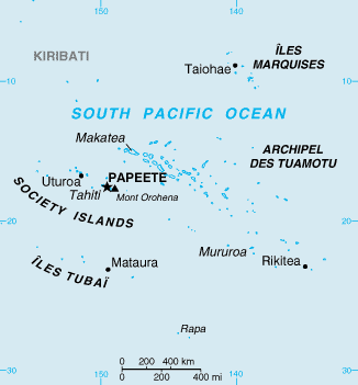
The Tuamotu Archipelago or the Tuamotu Islands (french: Îles Tuamotu, officially ) are a French Polynesian chain of just under 80 islands and atolls in the southern Pacific Ocean. They constitute the largest chain of atolls in the world, extending (from northwest to southeast) over an area roughly the size of Western Europe. Their combined land area is . This archipelago's major islands are Anaa, Fakarava, Hao and Makemo. The Tuamotus have approximately 16,000 inhabitants. The islands were initially settled by Polynesians, and modern Tuamotuans have inherited from them a shared culture and the Tuamotuan language. The Tuamotus are a French overseas collectivity. History The early history of the Tuamotu islands is generally unknown. Archaeological findings suggest that the western Tuamotus were settled from the Society Islands as early as 900 CE or as late as 1200 CE. DNA evidence suggests that they were settled about 1110 CE. On the islands of Rangiroa, Manihi and Mataiva, t ... [...More Info...] [...Related Items...] OR: [Wikipedia] [Google] [Baidu] |
Tuamotus
The Tuamotu Archipelago or the Tuamotu Islands (french: Îles Tuamotu, officially ) are a French Polynesian chain of just under 80 islands and atolls in the southern Pacific Ocean. They constitute the largest chain of atolls in the world, extending (from northwest to southeast) over an area roughly the size of Western Europe. Their combined land area is . This archipelago's major islands are Anaa, Fakarava, Hao and Makemo. The Tuamotus have approximately 16,000 inhabitants. The islands were initially settled by Polynesians, and modern Tuamotuans have inherited from them a shared Polynesian culture, culture and the Tuamotuan language. The Tuamotus are a overseas collectivity, French overseas collectivity. History The early history of the Tuamotu islands is generally unknown. Archaeological findings suggest that the western Tuamotus were settled from the Society Islands as early as 900 CE or as late as 1200 CE. DNA evidence suggests that they were settled about 1110 CE. On the ... [...More Info...] [...Related Items...] OR: [Wikipedia] [Google] [Baidu] |
Kaukura
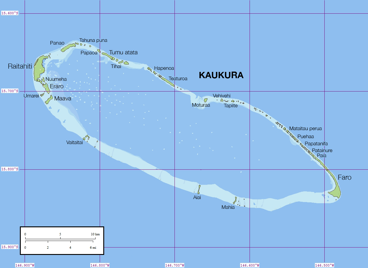
Kaukura or Kaheko is an atoll in the Tuamotu group in French Polynesia, long and wide. It is in the western area of the archipelago, southeast of Rangiroa. The closest land is Apataki Atoll, to the northeast. Kaukura Atoll is elongated, with a length of and a maximum width of . The northern reef rim is narrow, while the southern is broad. There are two groups of 65 islets. The surface of Kaukura's lagoon is and the land area . It has only one navigable pass cutting through the reef. The most important island is Motu Panao, in the atoll's northwest. Kaukura has 475 inhabitants ; the main village is Raitahiti. Geographically Kaukura belongs to the Palliser Islands (Îles Palliser) subgroup of the Tuamotus. History The first recorded European to arrive to Kaukura was Dutch Navigator Jakob Roggeveen on his expedition for the Dutch West India Company to seek Terra Australis in 1722. Formerly, fishing was the main occupation of Kaukura's islanders. But presently, touris ... [...More Info...] [...Related Items...] OR: [Wikipedia] [Google] [Baidu] |
Apataki
Apataki is a coral atoll in the South Pacific Ocean, territorially part of French Polynesia. It is one of the Palliser Islands, a subgroup of the Tuamotu Archipelago. Apataki is located approximately northeast of the island of Tahiti, east of Arutua and northeast of Kaukura. The island is approximately rectangular; it is long and wide. It has a total area of approximately 706 km2 with a land area of approximately . Two navigable passes enter its wide lagoon. , Apataki Atoll has 350 inhabitants, down from 492 in 2007. The main village is called Niutahi. History The first recorded European to sight Apataki Atoll was Dutch navigator Jakob Roggeveen in 1722. It was visited by James Cook in 1774. On 27 May 1902, while Paul Gauguin was living in the Marquesas Islands, the mail-boat ''Croix du Sud'' between Papeete and Atuona was shipwrecked at Apataki. leading to a three-month loss of supplies for the islanders. There is a domestic airfield in Apataki which was inaugurate ... [...More Info...] [...Related Items...] OR: [Wikipedia] [Google] [Baidu] |
Îles Tuamotu-Gambier
The Îles Tuamotu-Gambier (french: Îles Tuamotu-Gambier or ''Archipels des Tuamotu et des Gambier'' or ''Archipel des Tuamotu-Gambier'' or ''Tuamotu-Gambier'' or officially ''subdivision administrative des (Îles) Tuamotu-Gambier'') is an administrative division in French Polynesia. It consists of the Tuamotus and the Gambier Islands which are geographically located closely together. Because of a difference between administrative districts and electoral circumscriptions on the Îles Tuamotu-Gambier, French Polynesia has 5 administrative subdivisions (french: subdivisions administratives), but 6 electoral districts/electoral circumscriptions (french: circonscriptions électorales). It has an area of 726.5 square kilometers and an estimated population of 16,881 people according to data from 2017. Administrative division Administratively, the Îles Tuamotu-Gambier form one of the 5 administrative subdivisions (''subdivision administratives'') of French Polynesia, the administrativ ... [...More Info...] [...Related Items...] OR: [Wikipedia] [Google] [Baidu] |
Palliser Islands
The Palliser Islands or Pallisers are a subgroup of the Tuamotu group in French Polynesia. They are located in the very northwest of the main group of atolls. Atolls The group includes: *Apataki *Arutua *Fakarava *Kaukura *Mataiva *Rangiroa *Makatea *Tikehau *Toau Administration *Administratively, Apataki and Kaukura atolls belong to the commune of Arutua, with a total population of 1510 inhabitants. *Toau, Niau, and Fakarava, belong to the commune of Fakarava. The total population is of 1800 inhabitants. *The commune of Rangiroa consists of 3 atolls: Rangiroa itself, Tikehau and Mataiva, and a separate island (Makatea). The total population is of 3467 inhabitants. History The Palliser Islands were named "Palliser's Isles" by Captain James Cook, who was the first European to sight them, on 19 April and 20 April 1774; naming them as such in honour of Admiral Sir Hugh Palliser Admiral Sir Hugh Palliser, 1st Baronet (26 February 1723 – 19 March 1796) was a Royal Navy officer. ... [...More Info...] [...Related Items...] OR: [Wikipedia] [Google] [Baidu] |
Communes Of French Polynesia
In French Polynesia, there are two levels of administrative divisions: five administrative subdivisions (french: subdivisions administratives) and 48 communes.Codification des collectivités d'outre-mer (COM) INSEE, 1 March 2017Loi n° 2004-193 du 27 février 2004 complétant le statut d'autonomie de la Polynésie française (1) |
Communes Of France
The () is a level of administrative division in the French Republic. French are analogous to civil townships and incorporated municipalities in the United States and Canada, ' in Germany, ' in Italy, or ' in Spain. The United Kingdom's equivalent are civil parishes, although some areas, particularly urban areas, are unparished. are based on historical geographic communities or villages and are vested with significant powers to manage the populations and land of the geographic area covered. The are the fourth-level administrative divisions of France. vary widely in size and area, from large sprawling cities with millions of inhabitants like Paris, to small hamlets with only a handful of inhabitants. typically are based on pre-existing villages and facilitate local governance. All have names, but not all named geographic areas or groups of people residing together are ( or ), the difference residing in the lack of administrative powers. Except for the municipal arrondi ... [...More Info...] [...Related Items...] OR: [Wikipedia] [Google] [Baidu] |
Atoll
An atoll () is a ring-shaped island, including a coral rim that encircles a lagoon partially or completely. There may be coral islands or cays on the rim. Atolls are located in warm tropical or subtropical oceans and seas where corals can grow. Most of the approximately 440 atolls in the world are in the Pacific Ocean. Two different, well-cited models, the subsidence and antecedent karst models, have been used to explain the development of atolls.Droxler, A.W. and Jorry, S.J., 2021. ''The Origin of Modern Atolls: Challenging Darwin's Deeply Ingrained Theory.'' ''Annual Review of Marine Science'', 13, pp.537-573. According to Charles Darwin's ''subsidence model'', the formation of an atoll is explained by the subsidence of a volcanic island around which a coral fringing reef has formed. Over geologic time, the volcanic island becomes extinct and eroded as it subsides completely beneath the surface of the ocean. As the volcanic island subsides, the coral fringing reef becomes a ... [...More Info...] [...Related Items...] OR: [Wikipedia] [Google] [Baidu] |
Pacific Ocean
The Pacific Ocean is the largest and deepest of Earth's five oceanic divisions. It extends from the Arctic Ocean in the north to the Southern Ocean (or, depending on definition, to Antarctica) in the south, and is bounded by the continents of Asia and Oceania in the west and the Americas in the east. At in area (as defined with a southern Antarctic border), this largest division of the World Ocean—and, in turn, the hydrosphere—covers about 46% of Earth's water surface and about 32% of its total surface area, larger than Earth's entire land area combined .Pacific Ocean . '' Britannica Concise.'' 2008: Encyclopædia Britannica, Inc. The centers of both the |
Rangiroa
Rangiroa ( Tuamotuan for 'vast sky') or Te Kokōta (Cook Islands Māori for 'the Hyades star cluster') is the largest atoll in the Tuamotus and one of the largest in the world (smaller than Kwajalein in the Marshall Islands and Huvadhu in the Maldives). It is in French Polynesia and is part of the Palliser group. The nearest atoll is Tikehau, to the west. It is about northeast of Tahiti. Rangiroa is home to about 2,500 people on almost . The chief town is Avatoru, in the atoll's northwest. Geography and environment The atoll consists of about 415 motus, islets and sandbars comprising a total land area of about . There are approximately one hundred narrow passages (straits or passes), called ''hoa'', in the fringing reef. The atoll has a flattened elliptic shape, with in length and a width ranging from . The width of land reaches wide and its circumference totals up to . The lagoon has a maximum depth of and its surface is . It is so large that it has its own horizon. ... [...More Info...] [...Related Items...] OR: [Wikipedia] [Google] [Baidu] |


.jpg)
