|
Artifact Ridge
Artifact Ridge is a mountain ridge extending southeast from the eastern side of the Mount Edziza volcanic complex in northwestern British Columbia, Canada. It is bounded on the north by Bourgeaux Creek valley, on the south by Artifact Creek valley, on the east by the Little Iskut River valley and on the west by the Kitsu Plateau. The ridge is at the southeastern end of Mount Edziza Provincial Park and gets its name from the knapping of obsidian tools and points by early Tahltan hunters. Destell Pass cuts north–south through the westernmost end of Artifact Ridge. Geology The base of Artifact Ridge is covered with glacial, talus and landslide deposits. The oldest exposed rocks are of Mesozoic or Paleozoic age and are overlain by Miocene alkali basalt flows of the Raspberry Formation. The Raspberry rocks are overlain by quenched, hydrothermally altered and highly fractured Miocene trachybasalt which comprise the lower subaqueous facies of the Little Iskut Formation. Overlyin ... [...More Info...] [...Related Items...] OR: [Wikipedia] [Google] [Baidu] |
Google Earth
Google Earth is a computer program that renders a 3D computer graphics, 3D representation of Earth based primarily on satellite imagery. The program maps the Earth by superimposition, superimposing satellite images, aerial photography, and geographic information system, GIS data onto a 3D globe, allowing users to see cities and landscapes from various angles. Users can explore the globe by entering addresses and coordinates, or by using a Computer keyboard, keyboard or computer mouse, mouse. The program can also be downloaded on a smartphone or Tablet computer, tablet, using a touch screen or stylus to navigate. Users may use the program to add their own data using Keyhole Markup Language and upload them through various sources, such as forums or blogs. Google Earth is able to show various kinds of images overlaid on the surface of the earth and is also a Web Map Service client. In 2019, Google has revealed that Google Earth now covers more than 97 percent of the world, and has c ... [...More Info...] [...Related Items...] OR: [Wikipedia] [Google] [Baidu] |
Energy, Mines And Resources Canada
Natural Resources Canada (NRCan; french: Ressources naturelles Canada; french: RNCan, label=none)Natural Resources Canada is the applied title under the Federal Identity Program; the legal title is Department of Natural Resources (). is the department of the Government of Canada responsible for natural resources, energy, minerals and metals, forests, earth sciences, mapping, and remote sensing. It was formed in 1994 by amalgamating the Department of Energy, Mines and Resources with the Department of Forestry. Under the ''Constitution Act, 1867'', primary responsibility for natural resources falls to provincial governments, however, the federal government has jurisdiction over off-shore resources, trade and commerce in natural resources, statistics, international relations, and boundaries. The department administers federal legislation relating to natural resources, including energy, forests, minerals and metals. The department also collaborates with American and Mexican governme ... [...More Info...] [...Related Items...] OR: [Wikipedia] [Google] [Baidu] |
Trachybasalt
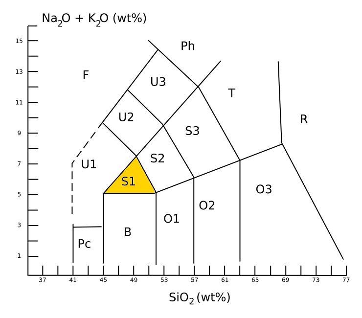
Trachybasalt is a volcanic rock with a composition between trachyte and basalt. It resembles basalt but has a high content of alkali metal oxides. Minerals in trachybasalt include alkali feldspar, calcic plagioclase, olivine, clinopyroxene and likely very small amounts of leucite or analcime. Description An aphanitic (fine-grained) igneous rock is classified as trachybasalt when it has a silica content of about 49% and a total alkali metal oxide content of about 6%. This places trachybasalt in the S1 field of the TAS classification, TAS diagram. Trachybasalt is further divided into sodium-rich ''hawaiite'' and potassium-rich ''potassic trachybasalt'', with wt% > + 2 for hawaiite. The intrusive equivalent of trachybasalt is monzonite. Trachybasalt is not defined on the QAPF diagram, which classifies crystalline igneous rock by its relative content of feldspars and quartz. However, the U.S. Geological Survey defines trachybasalt as a mafic volcanic rock (composed of over 35% maf ... [...More Info...] [...Related Items...] OR: [Wikipedia] [Google] [Baidu] |
Hydrothermally Altered
Metasomatism (from the Greek μετά ''metá'' "change" and σῶμα ''sôma'' "body") is the chemical alteration of a rock by hydrothermal and other fluids. It is the replacement of one rock by another of different mineralogical and chemical composition. The minerals which compose the rocks are dissolved and new mineral formations are deposited in their place. Dissolution and deposition occur simultaneously and the rock remains solid. Synonyms to the word metasomatism are metasomatose and metasomatic process. The word metasomatose can also be used as a name for specific varieties of metasomatism (for example '' Mg-metasomatose'' and '' Na-metasomatose''). Metasomatism can occur via the action of hydrothermal fluids from an igneous or metamorphic source. In the igneous environment, metasomatism creates skarns, greisen, and may affect hornfels in the contact metamorphic aureole adjacent to an intrusive rock mass. In the metamorphic environment, metasomatism is creat ... [...More Info...] [...Related Items...] OR: [Wikipedia] [Google] [Baidu] |
