|
April 26, 1991 Tornado Outbreak
From April 26–27, 1991, multiple supercells across Oklahoma and Kansas led to a regional tornado outbreak. Forced by a potent trough and focused along a dryline, these distinct thunderstorms moved northeast through a moist and highly unstable environment. A total of 55 tornadoes were confirmed, many of which were strong, F2 or greater on the Fujita scale. A widely documented F5 tornado tore through Andover, Kansas, killing 17 people. Additional fatalities occurred from significant tornadoes in other portions of Kansas and Oklahoma, with 21 deaths recorded in total. An F4 tornado was detected by a mobile doppler weather radar team which observed winds up to at the top of the funnel, the first time winds of F5 intensity were measured by radar, and the highest winds recorded by radar at the time. A news team filming an F2 tornado sought shelter under a Kansas Turnpike overpass, causing a misconception that overpasses can provide adequate shelter during a tornado. This ... [...More Info...] [...Related Items...] OR: [Wikipedia] [Google] [Baidu] |
Red Rock, Oklahoma
Red Rock ( iow, Chína Ino Šúje pronounced , meaning "Rock Red town") is a town in northern Noble County, Oklahoma, United States. The population was 283 at the 2010 census, a decline from 293 at the 2000 census. The headquarters of the Otoe-Missouria Tribe of Indians is located in Red Rock.Betty L. Waters, "Red Rock," ''Encyclopedia of Oklahoma History and Culture''. Accessed March 29, 2015. History In 1886, the built a line through what would become Noble County. The land around the railroad crossing of[...More Info...] [...Related Items...] OR: [Wikipedia] [Google] [Baidu] |
Bar (unit)
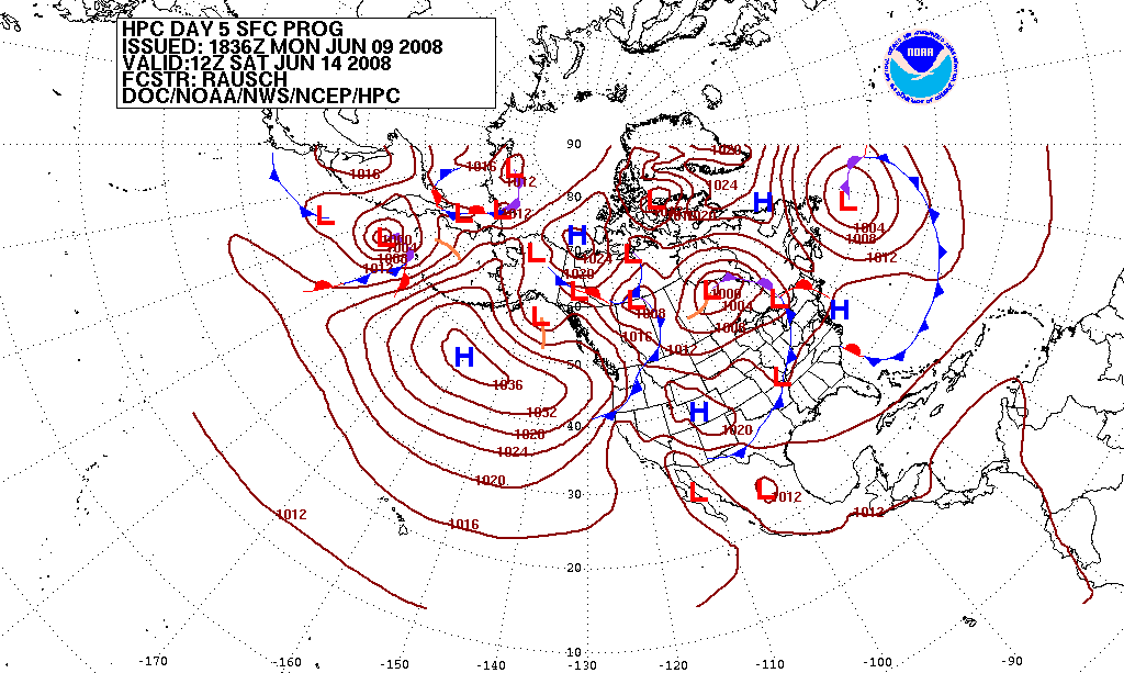
The bar is a metric unit of pressure, but not part of the International System of Units (SI). It is defined as exactly equal to 100,000 Pa (100 kPa), or slightly less than the current average atmospheric pressure on Earth at sea level (approximately 1.013 bar). By the barometric formula, 1 bar is roughly the atmospheric pressure on Earth at an altitude of 111 metres at 15 °C. The bar and the millibar were introduced by the Norwegian meteorologist Vilhelm Bjerknes, who was a founder of the modern practice of weather forecasting. The International System of Units, despite previously mentioning the bar, now omits any mention of it.. The bar has been legally recognised in countries of the European Union since 2004.British Standard BS 350:2004 ''Conversion Factors for Units''. The US National Institute of Standards and Technology (NIST) deprecates its use except for "limited use in meteorology" and lists it as one of several units that "must not be introduce ... [...More Info...] [...Related Items...] OR: [Wikipedia] [Google] [Baidu] |
Tonkawa, Oklahoma
Tonkawa is a city in Kay County, Oklahoma, United States, along the Salt Fork Arkansas River. The population was 3,216 at the 2010 census, a decline of 2.5 percent from the figure of 3,299 in 2000. History Named after the Tonkawa tribe, the city of Tonkawa was founded in March 1894, by Eli V. Blake and Wiley William Gregory. Blake and Gregory, originally from Kansas, claimed the land that would become Tonkawa in the Land Run of 1893. Prior to the land run, from 1879 to 1885, the area was known as "Fort Oakland", home to the Nez Perce people. In 1885, the remnants of the Tonkawa tribe, who had fled Indian Territory after the 1862 Tonkawa Massacre, returned to settle in the Fort Oakland area. The Blackwell and Southern Railway (later bought by the Atchison, Topeka and Santa Fe Railway) built a line through Tonkawa, which stimulated growth of the town. In 1901, the Oklahoma Territory Legislature established the University Preparatory School (now Northern Oklahoma College) here. B ... [...More Info...] [...Related Items...] OR: [Wikipedia] [Google] [Baidu] |
Coordinated Universal Time
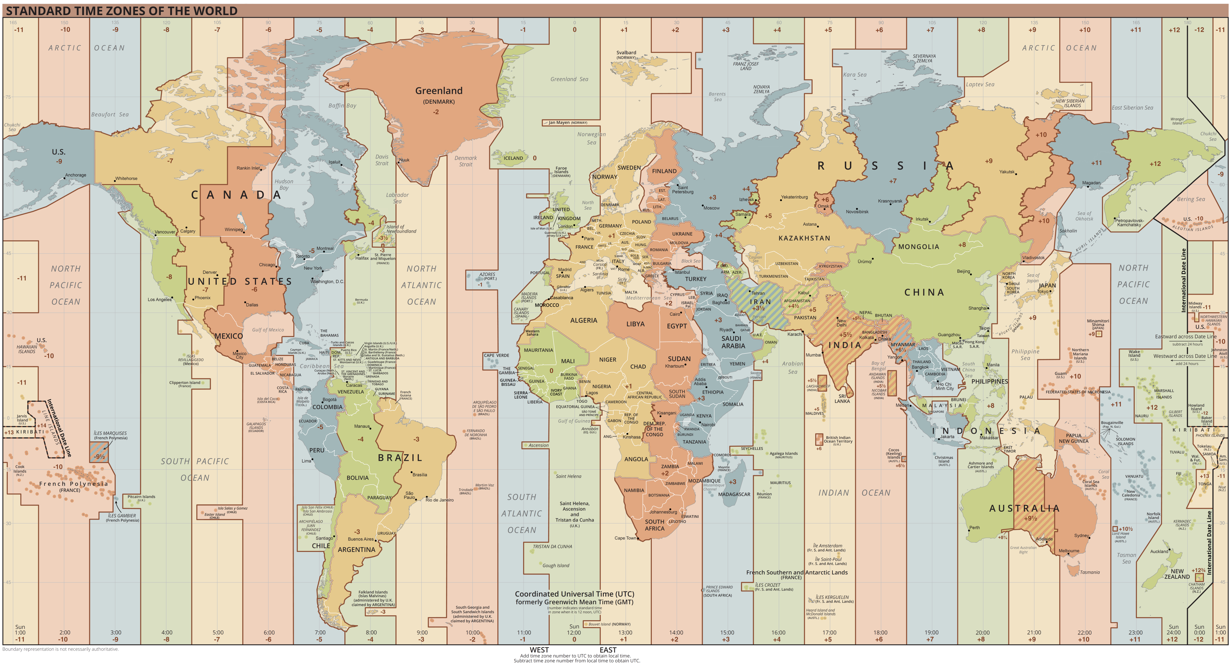
Coordinated Universal Time or UTC is the primary time standard by which the world regulates clocks and time. It is within about one second of mean solar time (such as UT1) at 0° longitude (at the IERS Reference Meridian as the currently used prime meridian) and is not adjusted for daylight saving time. It is effectively a successor to Greenwich Mean Time (GMT). The coordination of time and frequency transmissions around the world began on 1 January 1960. UTC was first officially adopted as CCIR Recommendation 374, ''Standard-Frequency and Time-Signal Emissions'', in 1963, but the official abbreviation of UTC and the official English name of Coordinated Universal Time (along with the French equivalent) were not adopted until 1967. The system has been adjusted several times, including a brief period during which the time-coordination radio signals broadcast both UTC and "Stepped Atomic Time (SAT)" before a new UTC was adopted in 1970 and implemented in 1972. This change also ... [...More Info...] [...Related Items...] OR: [Wikipedia] [Google] [Baidu] |
Time Zone
A time zone is an area which observes a uniform standard time for legal, commercial and social purposes. Time zones tend to follow the boundaries between countries and their subdivisions instead of strictly following longitude, because it is convenient for areas in frequent communication to keep the same time. All time zones are defined as offsets from Coordinated Universal Time (UTC), ranging from UTC−12:00 to UTC+14:00. The offsets are usually a whole number of hours, but a few zones are offset by an additional 30 or 45 minutes, such as in India, South Australia and Nepal. Some areas of higher latitude use daylight saving time for about half of the year, typically by adding one hour to local time during spring and summer. List of UTC offsets In the table below, the locations that use daylight saving time (DST) are listed in their UTC offset when DST is ''not'' in effect. When DST is in effect, approximately during spring and summer, their UTC offset is inc ... [...More Info...] [...Related Items...] OR: [Wikipedia] [Google] [Baidu] |
Supercell
A supercell is a thunderstorm characterized by the presence of a mesocyclone: a deep, persistently rotating updraft. Due to this, these storms are sometimes referred to as rotating thunderstorms. Of the four classifications of thunderstorms (supercell, squall line, multi-cell, and single-cell), supercells are the overall least common and have the potential to be the most severe. Supercells are often isolated from other thunderstorms, and can dominate the local weather up to away. They tend to last 2–4 hours. Supercells are often put into three classification types: classic (Normal precipitation level), low-precipitation (LP), and high-precipitation (HP). LP supercells are usually found in climates that are more arid, such as the high plains of the United States, and HP supercells are most often found in moist climates. Supercells can occur anywhere in the world under the right pre-existing weather conditions, but they are most common in the Great Plains of the United Stat ... [...More Info...] [...Related Items...] OR: [Wikipedia] [Google] [Baidu] |
Capping Inversion
A capping inversion is an elevated inversion layer that caps a convective planetary boundary layer. The boundary layer is the part of the atmosphere which is closest to the ground. Normally, the sun heats the ground, which in turn heats the air just above it. Thermals form when this warm air rises into the cold air (warm air is less dense than cold air), a process called convection. A convective layer such as this has the potential for cloud formation, since condensation occurs as the warm air rises and cools. An inversion occurs when the normal temperature (warm air below, cold air above) profile is reversed, creating a stable configuration of dense, cold air sitting below lighter, warm air. An elevated inversion layer is thus a region of warm air above a region of cold air, but higher in the atmosphere (generally not touching the surface). A capping inversion occurs when there is a boundary layer with a normal temperature profile (warm air rising into cooler air) and ... [...More Info...] [...Related Items...] OR: [Wikipedia] [Google] [Baidu] |
Convective Available Potential Energy
In meteorology, convective available potential energy (commonly abbreviated as CAPE), is the integrated amount of work that the upward (positive) buoyancy force would perform on a given mass of air (called an air parcel) if it rose vertically through the entire atmosphere. Positive CAPE will cause the air parcel to rise, while negative CAPE will cause the air parcel to sink. Nonzero CAPE is an indicator of atmospheric instability in any given atmospheric sounding, a necessary condition for the development of cumulus and cumulonimbus clouds with attendant severe weather hazards. Mechanics CAPE exists within the conditionally unstable layer of the troposphere, the free convective layer (FCL), where an ascending air parcel is warmer than the ambient air. CAPE is measured in joules per kilogram of air (J/kg). Any value greater than 0 J/kg indicates instability and an increasing possibility of thunderstorms and hail. Generic CAPE is calculated by integrating vertically the l ... [...More Info...] [...Related Items...] OR: [Wikipedia] [Google] [Baidu] |
Lifted Index
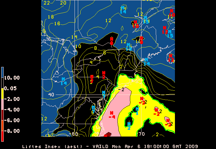
The lifted index (LI) is the temperature difference between the environment Te(p) and an air parcel lifted adiabatically Tp(p) at a given pressure height in the troposphere (lowest layer where most weather occurs) of the atmosphere, usually 500 hPa ( mb). The temperature is measured in Celsius. When the value is positive, the atmosphere (at the respective height) is stable and when the value is negative, the atmosphere is unstable. Determining LI LI can be computed using computer algorithms but can also be determined graphically. To do this, generally, the parcel is lifted from the portion of the planetary boundary layer (PBL) that lies below the morning inversion. The air here should be about 60 to 65% RH, which is then lifted along the dry adiabat (see also adiabatic process) to the lifting condensation level (LCL), which is the intersection of that curve with the average mixing ratio in the boundary layer. Once the LCL is found, the parcel is lifted along the moist adiab ... [...More Info...] [...Related Items...] OR: [Wikipedia] [Google] [Baidu] |
Dewpoint
The dew point is the temperature to which air must be cooled to become saturated with water vapor, assuming constant air pressure and water content. When cooled below the dew point, moisture capacity is reduced and airborne water vapor will condense to form liquid water known as dew. When this occurs via contact with a colder surface, dew will form on that surface. The dew point is affected by humidity. When there is more moisture in the air, the dew point is higher. When the temperature is below the freezing point of water, the dew point is called the frost point, as frost is formed via deposition rather than condensation. In liquids, the analog to the dew point is the cloud point. Humidity If all the other factors influencing humidity remain constant, at ground level the relative humidity rises as the temperature falls; this is because less vapor is needed to saturate the air. In normal conditions, the dew point temperature will not be greater than the air temperature, si ... [...More Info...] [...Related Items...] OR: [Wikipedia] [Google] [Baidu] |
Warm Front
A warm front is a density discontinuity located at the leading edge of a homogeneous warm air mass, and is typically located on the equator-facing edge of an isotherm gradient. Warm fronts lie within broader troughs of low pressure than cold fronts, and move more slowly than the cold fronts which usually follow because cold air is denser and less easy to remove from the Earth's surface. This also forces temperature differences across warm fronts to be broader in scale. Clouds ahead of the warm front are mostly stratiform, and rainfall defiantly increases as the front approaches. Fog can also occur preceding a warm frontal passage. Clearing and warming is usually rapid after frontal passage. If the warm air mass is unstable, thunderstorms may be embedded among the stratiform clouds ahead of the front, and after frontal passage thundershowers may continue. On weather maps, the surface location of a warm front is marked with a red line of semicircles pointing in the directio ... [...More Info...] [...Related Items...] OR: [Wikipedia] [Google] [Baidu] |


