|
Angel Peak Scenic Area
The Angel Peak Scenic Area is a BLM recreation area located about 15 miles south of Bloomfield in San Juan County, New Mexico. The recreation area, more than 10,000 acres of rugged terrain, features Angel Peak (elevation 6,988 feet), colorful badlands and deep canyons. Geology Angel Peak and the higher terrain are made up of the Eocene San Jose Formation (sandstone), and the badlands are made up of the underlying Paleocene Nacimiento Formation: shale, mudstone, and fine sandstone. Facilities Three picnic areas and a campground are located along the canyon rim overlooking Angel Peak and the Kutz Canyon badlands. Angel Peak Campground has nine sites available for tent camping, and features a short nature trail. Access to the area is via graded county road 7175, from US 550. See also *Bisti/De-Na-Zin Wilderness *Ah-Shi-Sle-Pah Wilderness Study Area *San Juan Basin The San Juan Basin is a geologic structural basin located near the Four Corners region of the Southwest ... [...More Info...] [...Related Items...] OR: [Wikipedia] [Google] [Baidu] |
Mudstone
Mudstone, a type of mudrock, is a fine-grained sedimentary rock whose original constituents were clays or muds. Mudstone is distinguished from '' shale'' by its lack of fissility (parallel layering).Blatt, H., and R.J. Tracy, 1996, ''Petrology.'' New York, New York, W. H. Freeman, 2nd ed, 529 pp. The term ''mudstone'' is also used to describe carbonate rocks (limestone or dolomite) that are composed predominantly of carbonate mud. However, in most contexts, the term refers to siliciclastic mudstone, composed mostly of silicate minerals. The NASA Curiosity rover has found deposits of mudstone on Mars that contain organic substances such as propane, benzene and toluene. Definition There is not a single definition of mudstone that has gained general acceptance,Boggs 2006, p.143 though there is wide agreement that mudstones are fine-grained sedimentary rocks, composed mostly of silicate grains with a grain size less than . Individual grains this size are too small to be disting ... [...More Info...] [...Related Items...] OR: [Wikipedia] [Google] [Baidu] |
Cenozoic New Mexico
The Cenozoic ( ; ) is Earth's current geological era, representing the last 66million years of Earth's history. It is characterised by the dominance of mammals, birds and flowering plants, a cooling and drying climate, and the current configuration of continents. It is the latest of three geological eras since complex life evolved, preceded by the Mesozoic and Paleozoic. It started with the Cretaceous–Paleogene extinction event, when many species, including the non-avian dinosaurs, became extinct in an event attributed by most experts to the impact of a large asteroid or other celestial body, the Chicxulub impactor. The Cenozoic is also known as the Age of Mammals because the terrestrial animals that dominated both hemispheres were mammalsthe eutherians (placentals) in the northern hemisphere and the metatherians (marsupials, now mainly restricted to Australia) in the southern hemisphere. The extinction of many groups allowed mammals and birds to greatly diversify so that larg ... [...More Info...] [...Related Items...] OR: [Wikipedia] [Google] [Baidu] |
Bureau Of Land Management Areas In New Mexico
Bureau ( ) may refer to: Agencies and organizations * Government agency *Public administration * News bureau, an office for gathering or distributing news, generally for a given geographical location * Bureau (European Parliament), the administrative organ of the Parliament of the European Union * Federal Bureau of Investigation, the leading internal law enforcement agency in the United States * Service bureau, a company which provides business services for a fee * Citizens Advice Bureau, a network of independent UK charities that give free, confidential help to people for money, legal, consumer and other problems Furniture * Desk, a piece of furniture, typically a table used for office work * Chest of drawers, a piece of furniture that has multiple, stacked, parallel drawers Geography * Bureau County, Illinois * Bureau Lake, a body of water in the Gouin Reservoir, in Quebec, Canada People * Bernard Béréau (1940–2005), French footballer * Bernard Bureau (born 1959), Fre ... [...More Info...] [...Related Items...] OR: [Wikipedia] [Google] [Baidu] |
San Juan Basin
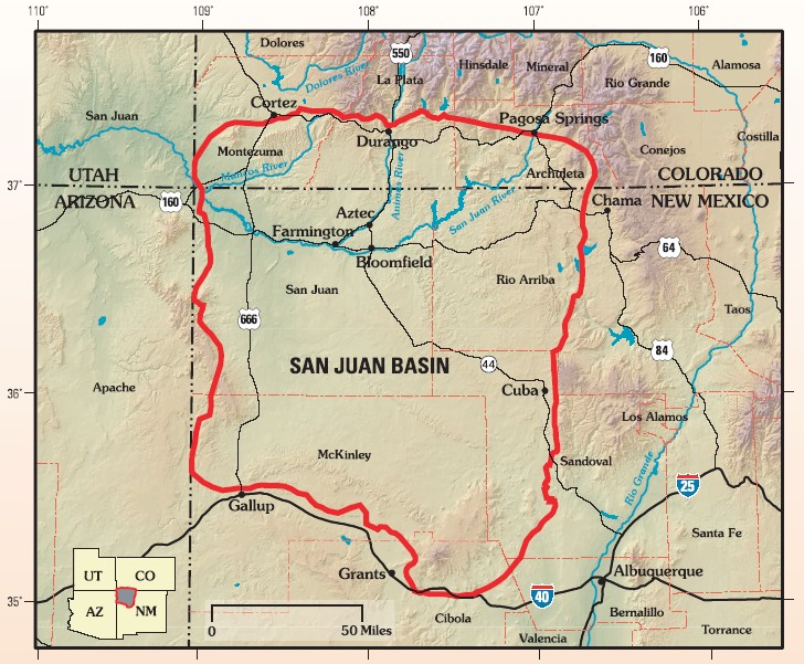
The San Juan Basin is a geologic structural basin located near the Four Corners region of the Southwestern United States. The basin covers 7,500 square miles and resides in northwestern New Mexico, southwestern Colorado, and parts of Utah and Arizona. Specifically, the basin occupies space in the San Juan, Rio Arriba, Sandoval, and McKinley counties in New Mexico, and La Plata and Archuleta counties in Colorado. The basin extends roughly N-S and E-W. The San Juan Basin is an asymmetric structural depression in the Colorado Plateau province, with varying elevation and nearly in topographic relief. Its most striking features include Chaco Canyon (northwestern New Mexico, between Farmington and Santa Fe) and Chacra Mesa. The basin lies west of the Continental Divide, and its main drainage is the southwest- to west-flowing San Juan River, which eventually joins the Colorado River in Utah. Climate of the basin is arid to semiarid, with an annual precipitation of and an a ... [...More Info...] [...Related Items...] OR: [Wikipedia] [Google] [Baidu] |
Ah-Shi-Sle-Pah Wilderness Study Area
Ah-Shi-Sle-Pah Wilderness is located in San Juan County, New Mexico, between Chaco Canyon and the De-Na-Zin Wilderness. Its name is a phonetic transliteration of Navajo " áshįįh łibá" meaning "salt, it is grey (grey salt)". The wilderness has multicolored badlands, sandstone hoodoos, petrified wood and dinosaur bones, similar to those found in the nearby Bisti Badlands and De-Na-Zin Wilderness. History The BLM Wilderness Study Area (WSA) was declared in May 1992 and would protect an area of about 26.5 km2 (6,563 acres). The area was prospected by the dinosaur hunter Charles Hazelius Sternberg in the summer of 1921. Sternberg collected the type specimen of '' Pentaceratops fenestratus'', a ceratopsid dinosaur from the late Cretaceous Period, within the WSA. Specimens from this area form a significant part of the vertebrate paleontology collection at the Museum of Evolution, University of Uppsala, Sweden.Sullivan, R.M. 2006. Ah-shi-sle-pah Wilderness Study Area (San ... [...More Info...] [...Related Items...] OR: [Wikipedia] [Google] [Baidu] |
Bisti/De-Na-Zin Wilderness
The Bisti/De-Na-Zin Wilderness is a wilderness area located in San Juan County in the U.S. state of New Mexico. Established in 1984, the Wilderness is a desolate area of steeply eroded badlands managed by the Bureau of Land Management, except three parcels of private Navajo land within its boundaries.Bisti/De-Na-Zin Wilderness - Wilderness.net The , signed March 12, 2019, expanded the Bisti/De-Na-Zin Wilderness by approximately 2,250 acres. Translated from the |
US 550
U.S. Route 550 (US 550) is a spur of U.S. Highway 50 that runs from Bernalillo, New Mexico to Montrose, Colorado in the western United States. The section from Silverton to Ouray is frequently called the Million Dollar Highway.Road Trip America – Million Dollar Highway by Mark Sedenquist accessed Oct 21, 2007 It is one of the roads on the Trails of the Ancients Byway, one of the designated . [...More Info...] [...Related Items...] OR: [Wikipedia] [Google] [Baidu] |
Nature Trail
An educational trail (or sometimes educational path), nature trail or nature walk is a specially developed hiking trail or footpath that runs through the countryside, along which there are marked stations or stops next to points of natural, technological or cultural interest. These may convey information about, for example, flora and fauna, soil science, geology, mining, ecology or cultural history. Longer trails, that link more widely spaced natural phenomena or structures together, may be referred to as themed trails or paths. In order to give a clearer explanation of the objects located at each station, display boards or other exhibits are usually erected, in keeping with the purpose of the trail. These may include: information boards, photographs and pictures, maps or plans, display cases and models, slides, sound or multimedia devices, facilities to enable experimentation and so on. The routes are regularly maintained. Educational trails with a strong thematic content may a ... [...More Info...] [...Related Items...] OR: [Wikipedia] [Google] [Baidu] |
Nacimiento Formation
The Nacimiento Formation is a sedimentary rock formation found in the San Juan Basin of western New Mexico (United States). It has an age of 61 to 65.7 million years, corresponding to the early and middle Paleocene. The formation has yielded an abundance of fossils from shortly after the Cretaceous-Paleogene extinction event that provide clues to the recovery and diversification of mammals following the extinction event. Description The Nacimiento Formation is a heterogeneous nonmarine formation composed of shale, siltstone, and sandstone, deposited in floodplain, fluvial and lacustrine settings, and made up of sediment shed from the San Juan uplift to the north and the Brazos-Sangre de Cristo uplift to the east. It was deposited mostly between ~65.7 and ~61 million years ago, during the early and middle Paleocene. The climate was humid and warm to hot and stable, but with a distinct dry season. This unit interbeds with the underlying Ojo Alamo Formation but is separat ... [...More Info...] [...Related Items...] OR: [Wikipedia] [Google] [Baidu] |
Angel Peak
Angel Sar or Angel Peak ( ur, ) is a mountain in Karakoram The Karakoram is a mountain range in Kashmir region spanning the borders of Pakistan, China, and India, with the northwest extremity of the range extending to Afghanistan and Tajikistan. Most of the Karakoram mountain range falls under the ... range of Gilgit–Baltistan, Pakistan, near K2, the second highest mountain on Earth. References Mountains of Gilgit-Baltistan Six-thousanders of the Karakoram {{Asia-mountain-stub ... [...More Info...] [...Related Items...] OR: [Wikipedia] [Google] [Baidu] |
Paleocene
The Paleocene, ( ) or Palaeocene, is a geological epoch (geology), epoch that lasted from about 66 to 56 mya (unit), million years ago (mya). It is the first epoch of the Paleogene Period (geology), Period in the modern Cenozoic Era (geology), Era. The name is a combination of the Ancient Greek ''palaiós'' meaning "old" and the Eocene Epoch (which succeeds the Paleocene), translating to "the old part of the Eocene". The epoch is bracketed by two major events in Earth's history. The K–Pg extinction event, brought on by Chicxulub impact, an asteroid impact and possibly volcanism, marked the beginning of the Paleocene and killed off 75% of living species, most famously the non-avian dinosaurs. The end of the epoch was marked by the Paleocene–Eocene Thermal Maximum (PETM), which was a major climatic event wherein about 2,500–4,500 gigatons of carbon were released into the atmosphere and ocean systems, causing a spike in global temperatures and ocean acidification. In the Pal ... [...More Info...] [...Related Items...] OR: [Wikipedia] [Google] [Baidu] |


.jpg)


