|
Ancient Geographic Names In Croatia
This is a list of geographic names from ancient times in the current Republic of Croatia with modern names. Some of the current names refer to places that are only nearby. These include Illyrian, Ancient Greek, and Roman names. Regions Towns Rivers and streams Populated islands See also *List of ancient cities in Illyria This is a list of settlements in Illyria founded by Illyrians (southern Illyrians, Dardanians, Pannonians), Liburni, Ancient Greeks and the Roman Empire. A number of cities in Illyria and later Illyricum were built on the sites or close to the s ... References Sources * * External linksDawn of Recorded History at Antonio Sciarretta's Toponymy Posljedna faza osvajanja južne Panonije Bellum Pannonicum (12.– ... [...More Info...] [...Related Items...] OR: [Wikipedia] [Google] [Baidu] |
Republic Of Croatia
, image_flag = Flag of Croatia.svg , image_coat = Coat of arms of Croatia.svg , anthem = "Lijepa naša domovino"("Our Beautiful Homeland") , image_map = , map_caption = , capital = Zagreb , coordinates = , largest_city = capital , official_languages = Croatian , languages_type = Writing system , languages = Latin , ethnic_groups = , ethnic_groups_year = 2021 , religion = , religion_year = 2021 , demonym = , government_type = Unitary parliamentary republic , leader_title1 = President , leader_name1 = Zoran Milanović , leader_title2 = Prime Minister , leader_name2 = Andrej Plenković , leader_title3 = Speaker of Parliament , leader_name3 = Gordan Jandroković , legislature = Sabor , sovereignty_type = ... [...More Info...] [...Related Items...] OR: [Wikipedia] [Google] [Baidu] |
Baranja Region
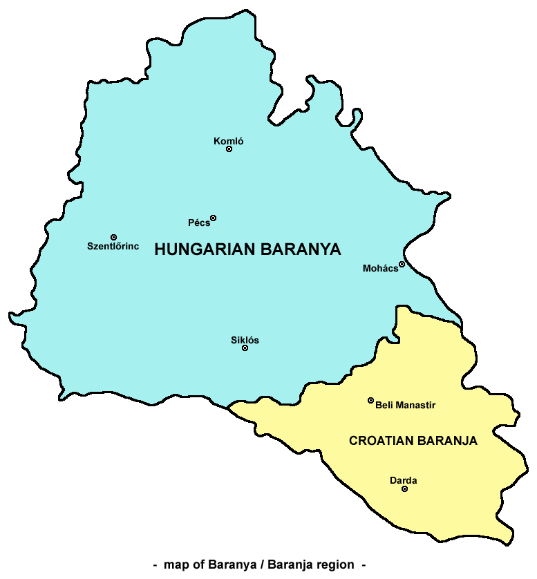
Baranya or Baranja ( hr, Baranja, ; hu, Baranya, ) is a geographical and historical region between the Danube and the Drava rivers. Its territory is divided between Hungary and Croatia. In Hungary, the region is included into Baranya county, while in Croatia, it is included into Osijek-Baranja county. Name The name of the region come from the Slavic word 'bara', which means 'marsh', 'bog', thus the name of Baranya means 'marshland'. Even today large parts of the region are swamps, such as the natural reservation Kopački Rit in its southeast. Another theory states that the name of the region comes from the Croatian and Hungarian word 'bárány', which means ram of 'ovis'. History Historically, the region of Baranya was part of the Roman Empire, the Hunnic Empire, the Kingdom of the Ostrogoths, the Kingdom of the Lombards, the Avar Kingdom, the Frankish Empire, the Balaton Principality, the Bulgarian Empire, the Kingdom of Hungary, the Ottoman Empire, the Habsburg monarch ... [...More Info...] [...Related Items...] OR: [Wikipedia] [Google] [Baidu] |
Daruvar
Daruvar ( cz, Daruvar, german: Daruwar, hu, Daruvár, sr, Дарувар, la, Aquae Balissae) is a spa town and municipality in Slavonia, northeastern Croatia with a population of 8,567. The area including the surrounding villages (Dar. Vinogradi, Doljani, Donji Daruvar, Gornji Daruvar, Lipovac Majur, Ljudevit Selo, Markovac, and Vrbovac) has a population of 11,633 as of 2011. It is located on the foothills of Papuk mountain and along the Toplica River. The main political and cultural centre of the Czechs of Croatia, Czech national minority in Croatia, it has a winemaking tradition reportedly dating back more than 2,000 years. Geography * Coordinates: * Area: 64 km2 * Altitude: 190 m Daruvar is located 125 km from Zagreb, the national capital, and 130 km from Osijek, the main city of Slavonia to the east. The closest cities are Pakrac, Lipik, Novska, Križevci, Croatia, Križevci, Bjelovar, and Virovitica. Administration Daruvar is located in the Bjelovar-Bi ... [...More Info...] [...Related Items...] OR: [Wikipedia] [Google] [Baidu] |
Aquae Balissae
Daruvar ( cz, Daruvar, german: Daruwar, hu, Daruvár, sr, Дарувар, la, Aquae Balissae) is a spa town and municipality in Slavonia, northeastern Croatia with a population of 8,567. The area including the surrounding villages (Dar. Vinogradi, Doljani, Donji Daruvar, Gornji Daruvar, Lipovac Majur, Ljudevit Selo, Markovac, and Vrbovac) has a population of 11,633 as of 2011. It is located on the foothills of Papuk mountain and along the Toplica River. The main political and cultural centre of the Czech national minority in Croatia, it has a winemaking tradition reportedly dating back more than 2,000 years. Geography * Coordinates: * Area: 64 km2 * Altitude: 190 m Daruvar is located 125 km from Zagreb, the national capital, and 130 km from Osijek, the main city of Slavonia to the east. The closest cities are Pakrac, Lipik, Novska, Križevci, Bjelovar, and Virovitica. Administration Daruvar is located in the Bjelovar-Bilogora County. The list of settlements ... [...More Info...] [...Related Items...] OR: [Wikipedia] [Google] [Baidu] |
Labin
Labin (Italian/Istriot: Albona) is a town in Istria, west Croatia, with a town population of 5,806 (2021) and 10,424 in the greater municipality (which also includes the small towns of Rabac and Vinež, as well as a number of smaller villages). History Labin developed from the site of the Roman settlement of Albona. Its name predates classical antiquity and is derived from Proto-Indo-European ''*alb-'' ("eminence", "hill"). Before and under the Roman occupation, Albona was an important commune. On a marble tablet the Roman inscription we read that under the Emperor Marco Iulio Severo Filippo noble Caesar noble Prince made Albona a Republic. To be a republic it had to have two joined Magistrates called Duumviri and Public officers called Aediles which took care of Public buildings and other official duties. From 1295 it was under the rule of the dukes of Pazin, and from 1381 it found itself under the jurisdiction of the Patriarchate of Aquileia. From 1420 until 1797 it was ruled fr ... [...More Info...] [...Related Items...] OR: [Wikipedia] [Google] [Baidu] |
Albona
Labin (Italian/Istriot: Albona) is a town in Istria, west Croatia, with a town population of 5,806 (2021) and 10,424 in the greater municipality (which also includes the small towns of Rabac and Vinež, as well as a number of smaller villages). History Labin developed from the site of the Roman settlement of Albona. Its name predates classical antiquity and is derived from Proto-Indo-European ''*alb-'' ("eminence", "hill"). Before and under the Roman occupation, Albona was an important commune. On a marble tablet the Roman inscription we read that under the Emperor Marco Iulio Severo Filippo noble Caesar noble Prince made Albona a Republic. To be a republic it had to have two joined Magistrates called Duumviri and Public officers called Aediles which took care of Public buildings and other official duties. From 1295 it was under the rule of the dukes of Pazin, and from 1381 it found itself under the jurisdiction of the Patriarchate of Aquileia. From 1420 until 1797 it was ruled fr ... [...More Info...] [...Related Items...] OR: [Wikipedia] [Google] [Baidu] |
Sinj
Sinj (; it, Signo; german: Zein) is a town in the continental part of Split-Dalmatia County, Croatia. The town itself has a population of 11,478 and the population of the administrative municipality, which includes surrounding villages, is 24,826 (2011). Geography Sinj is located in the heart of the Dalmatian hinterland, the area known as ''Cetinska krajina'', a group of settlements situated on a fertile karstic field of Sinjsko polje through which the river Cetina passes. Sinj lies between four mountains: Svilaja, Dinara, Kamešnica and Visoka. Those mountains give Sinj its specific submediterranean climate (hotter summers and colder winters). History Sinj was seized by the Turks in 1524 who maintained control until 1686, when it was taken into possession by the Venetians. The town grew around an ancient fortress held by the Ottomans from 16th until the end of 17th century, and the Franciscan monastery with the church of Our Lady of Sinj (), a place of pilgrimage. The l ... [...More Info...] [...Related Items...] OR: [Wikipedia] [Google] [Baidu] |
Aequum
Aequum was a Roman colony located near modern-day Čitluk, a village near Sinj, Croatia. Location The valley of the middle part of the Cetina river and its surrounding area, known as the District of Cetina, represent the backbone of the entire area and separate geographical region of mountainous Dalmatian hinterland. Its stream flows through dry karst fields covered by sub-Mediterranean vegetation where many archaeological remains are preserved. Modern day Čitluk is situated near the town Sinj at the edge of the Cetina valley. History and significance During the Roman administration in the mid-first century AD, Aequum reached the status of an agrarian Roman colony after it was settled by the veterans of Legio VII Claudia Pia Fidelis during the rule of emperor Claudius (41–45 AD). The colonia was founded by Claudius and named ''colonia Claudia Aequum''; it was the only colony in the interior of the province of Dalmatia. Aequum was a planned city of enclosed by walls wit ... [...More Info...] [...Related Items...] OR: [Wikipedia] [Google] [Baidu] |
Nin, Croatia
Nin ( it, Nona, la, Aenona or ''Nona'') is a town in the Zadar County of Croatia, population 1,132, total municipality population 2,744 (2011). Nin was historically important as a centre of a medieval Christian Diocese of Nin. Nin was also the seat of the Princes of Dalmatia. Geography Nin's historical center is located on an islet only 500 meters in diameter. Nin is situated in a lagoon on the eastern shore of the Adriatic Sea, surrounded by natural sandy beaches and linked with the mainland by two stone bridges from the 16th century. History According to historians the area of Nin appears to have been settled 10,000 years ago. The present-day town on the islet developed 3,000 years ago and is one of the older towns on the eastern Adriatic. The area of Nin was first colonized by immemorial people of the Mediterranean. Since the 9th century B.C. the civilization of the Illyrian tribe of Liburnians was present before the Romans came, who had a strong sea and trade center call ... [...More Info...] [...Related Items...] OR: [Wikipedia] [Google] [Baidu] |
Aenona
Nin ( it, Nona, la, Aenona or ''Nona'') is a town in the Zadar County of Croatia, population 1,132, total municipality population 2,744 (2011). Nin was historically important as a centre of a medieval Christian Diocese of Nin. Nin was also the seat of the Princes of Dalmatia. Geography Nin's historical center is located on an islet only 500 meters in diameter. Nin is situated in a lagoon on the eastern shore of the Adriatic Sea, surrounded by natural sandy beaches and linked with the mainland by two stone bridges from the 16th century. History According to historians the area of Nin appears to have been settled 10,000 years ago. The present-day town on the islet developed 3,000 years ago and is one of the older towns on the eastern Adriatic. The area of Nin was first colonized by immemorial people of the Mediterranean. Since the 9th century B.C. the civilization of the Illyrian tribe of Liburnians was present before the Romans came, who had a strong sea and trade center call ... [...More Info...] [...Related Items...] OR: [Wikipedia] [Google] [Baidu] |


