|
Anatolian Diagonal
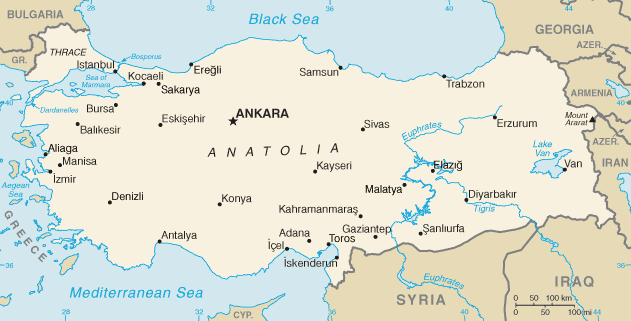
The Anatolian diagonal is a theoretical dividing line which runs diagonally across central and eastern Turkey from the northeastern corner of the Mediterranean Sea to the southeastern corner of the Black Sea, and roughly cuts across part of the course of the upper Euphrates River within Turkey's borders. Biogeographical barrier The diagonal was first proposed by the British botanist Peter Hadland Davis in 1971. He noticed that many species of plant that existed west of the diagonal were not present to the east, while others found to the east were not present to the west. Of 550 species analysed, 135 were "eastern" and 228 "western". However, Davis considered that there were no physical, geological or climatic differences or change in soil type that could account for the phenomenon. Not only does the Anatolian diagonal form a barrier to floral biodiversity, but about four hundred species of plant are endemic to this diagonal and are found nowhere else. In 1989, the Turkish botan ... [...More Info...] [...Related Items...] OR: [Wikipedia] [Google] [Baidu] |
Irano-Anatolian
The Irano-Anatolian region is a biodiversity hotspot designated by Conservation International's Critical Ecosystem Partnership Fund, extending across portions of Armenia, Azerbaijan, Georgia, Iraq, Iran, Turkey, and Turkmenistan. This hotspot covers the South-West portion of the Irano-Turanian floristic region, connecting the Mediterranean Basin with Western Asia. It includes highlands of the central and eastern Anatolian Plateau as well as the Zagros, Alborz, and Kopet Dag mountain ranges. The ecoregions included within the hotspot are: * Central Anatolian steppe * Central Anatolian deciduous forests * Eastern Anatolian deciduous forests * Eastern Anatolian montane steppe * Elburz Range forest steppe * Kopet Dag woodlands and forest steppe * Zagros Mountains forest steppe The Zagros Mountains forest steppe is a temperate broadleaf and mixed forests ecoregion in Western Asia. The ecoregion extends along the Zagros Mountains, stretching from eastern Turkey and northern I ... [...More Info...] [...Related Items...] OR: [Wikipedia] [Google] [Baidu] |
Speciation
Speciation is the evolutionary process by which populations evolve to become distinct species. The biologist Orator F. Cook coined the term in 1906 for cladogenesis, the splitting of lineages, as opposed to anagenesis, phyletic evolution within lineages. Charles Darwin was the first to describe the role of natural selection in speciation in his 1859 book ''On the Origin of Species''. He also identified sexual selection as a likely mechanism, but found it problematic. There are four geographic modes of speciation in nature, based on the extent to which speciating populations are isolated from one another: allopatric speciation, allopatric, peripatric speciation, peripatric, parapatric speciation, parapatric, and sympatric speciation, sympatric. Speciation may also be induced artificially, through animal husbandry, agriculture, or laboratory experiments of speciation, laboratory experiments. Whether genetic drift is a minor or major contributor to speciation is the subject of much ... [...More Info...] [...Related Items...] OR: [Wikipedia] [Google] [Baidu] |
Taurus Mountains
The Taurus Mountains ( Turkish: ''Toros Dağları'' or ''Toroslar'') are a mountain complex in southern Turkey, separating the Mediterranean coastal region from the central Anatolian Plateau. The system extends along a curve from Lake Eğirdir in the west to the upper reaches of the Euphrates and Tigris rivers in the east. It is a part of the Alpide belt in Eurasia. Etymology The mountain range under the current name was mentioned in ''The Histories'' by Polybius as Ταῦρος (''Taûros''). Heinrich Kiepert writes in ''Lehrbuch der alten Geographie'' that the name was borrowed into Ancient Greek from the Semitic (Old Aramaic) root טורא ''ṭūrā'', meaning "mountain". Geography The Taurus mountains are divided into three chains from west to east as follows; * Western Taurus (Batı Toroslar) *Central Taurus (Orta Toroslar) *Southeastern Taurus (Güneydoğu Toroslar) Western Taurus The Western Taurus Mountains form an arc around the Gulf of Antalya. It includes th ... [...More Info...] [...Related Items...] OR: [Wikipedia] [Google] [Baidu] |
Near East
The ''Near East''; he, המזרח הקרוב; arc, ܕܢܚܐ ܩܪܒ; fa, خاور نزدیک, Xāvar-e nazdik; tr, Yakın Doğu is a geographical term which roughly encompasses a transcontinental region in Western Asia, that was once the historical Fertile Crescent, and later the Levant region. It also comprises Turkey (both Anatolia and East Thrace) and Egypt (mostly located in North Africa, with the Sinai Peninsula being in Asia). Despite having varying definitions within different academic circles, the term was originally applied to the maximum extent of the Ottoman Empire. According to the National Geographic Society, the terms ''Near East'' and ''Middle East'' denote the same territories and are "generally accepted as comprising the countries of the Arabian Peninsula, Cyprus, Egypt, Iraq, Iran, Israel, Jordan, Lebanon, Palestinian territories, Syria, and Turkey". In 1997, the Food and Agriculture Organization of the United Nations, Food and Agriculture Organization (FAO) ... [...More Info...] [...Related Items...] OR: [Wikipedia] [Google] [Baidu] |
Sea Of Marmara
The Sea of Marmara,; grc, Προποντίς, Προποντίδα, Propontís, Propontída also known as the Marmara Sea, is an inland sea located entirely within the borders of Turkey. It connects the Black Sea to the Aegean Sea via the Bosporus and Dardanelles straits, separating the country's European and Asian sides. The Sea of Marmara is a small sea with an area of , and dimensions of . Its greatest depth is . Name The Sea of Marmara is named after the largest island to its south side which is called Marmara Island because it is rich in marble (Greek (''mármaron'') "marble)." In classical antiquity it was known as the Propontis, which is derived from the Greek words ''pro-'' (before) and ''pontos'' (sea) and reflects the fact that the Ancient Greeks used to sail through it to reach the Black Sea that they called Pontos. Mythology In Greek mythology, a storm on the Propontis brought the Argonauts back to an island they had left, precipitating a battle in which ... [...More Info...] [...Related Items...] OR: [Wikipedia] [Google] [Baidu] |
Bosphorus
The Bosporus Strait (; grc, Βόσπορος ; tr, İstanbul Boğazı 'Istanbul strait', colloquially ''Boğaz'') or Bosphorus Strait is a natural strait and an internationally significant waterway located in Istanbul in northwestern Turkey. It forms part of the continental boundary between Asia and Europe, and divides Turkey by separating Anatolia from Thrace. It is the world's narrowest strait used for international navigation. Most of the shores of the Bosporus Strait, except for the area to the north, are heavily settled, with the city of Istanbul's metropolitan population of 17 million inhabitants extending inland from both banks. The Bosporus Strait and the Dardanelles Strait at the opposite end of the Sea of Marmara are together known as the Turkish Straits. Sections of the shore of the Bosporus in Istanbul have been reinforced with concrete or rubble and those sections of the Strait prone to deposition are periodically dredged. Name The name of the ... [...More Info...] [...Related Items...] OR: [Wikipedia] [Google] [Baidu] |
Land Bridge
In biogeography, a land bridge is an isthmus or wider land connection between otherwise separate areas, over which animals and plants are able to cross and Colonisation (biology), colonize new lands. A land bridge can be created by marine regression, in which sea levels fall, exposing shallow, previously submerged sections of continental shelf; or when new land is created by plate tectonics; or occasionally when the sea floor rises due to post-glacial rebound after an ice age. Prominent examples * Adam's Bridge (also known as Rama Setu), connecting India and Sri Lanka * The Bass Strait#Discovery and exploration, Bassian Plain, which linked Australia and Tasmania * The Beringia, Bering Land Bridge (aka Beringia), which intermittently connected Alaska (Northern America) with Siberia (North Asia) as sea levels rose and fell under the effect of ice ages * East Asia’s former unnamed landmass, During the last Ice Age, which ended approximately 15,000 years ago, Japanese Archipela ... [...More Info...] [...Related Items...] OR: [Wikipedia] [Google] [Baidu] |
Late Pleistocene
The Late Pleistocene is an unofficial Age (geology), age in the international geologic timescale in chronostratigraphy, also known as Upper Pleistocene from a Stratigraphy, stratigraphic perspective. It is intended to be the fourth division of the Pleistocene Epoch within the ongoing Quaternary Period. It is currently defined as the time between c. 129,000 and c. 11,700 years ago. The Late Pleistocene equates to the proposed Tarantian Age of the geologic time scale, preceded by the officially ratified Chibanian (formerly known as Middle Pleistocene) and succeeded by the officially ratified Greenlandian. The estimated beginning of the Tarantian is the start of the Eemian interglacial period (Marine Isotope Stage 5). It is held to end with the termination of the Younger Dryas, some 10th millennium BC, 11,700 years ago when the Holocene Epoch began. The term Upper Pleistocene is currently in use as a provisional or "quasi-formal" designation by the International Union of Geological ... [...More Info...] [...Related Items...] OR: [Wikipedia] [Google] [Baidu] |
Glacial Refugium
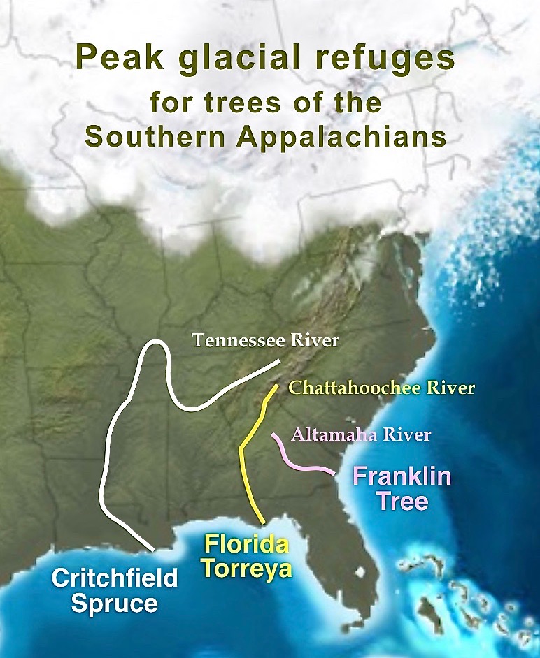
A glacial refugium (''plural refugia'') is a geographic region which made possible the survival of flora and fauna in times of ice ages and allowed for post-glacial re-colonization. Different types of glacial refugia can be distinguished, namely nunatak, peripheral and lowland refugia.Holderegger, R., Thiel-Egenter, C. (2009): A discussion of different types of glacial refugia used in mountain biogeography and phytogeography. Journal of Biogeography 36, 476-480. Glacial refugia have been suggested as a major cause of the patterns of distributions of flora and fauna in both temperate and tropical latitudes. With respect to disjunct populations of modern-day species distributions, especially in birds, doubt has been cast on the validity of such inferences, as much of the differentiation between populations observed today may have occurred before or after their restriction to refugia. In contrast, isolated geographic locales that host one or more critically endangered species (regarded ... [...More Info...] [...Related Items...] OR: [Wikipedia] [Google] [Baidu] |
Quaternary Glaciation
The Quaternary glaciation, also known as the Pleistocene glaciation, is an alternating series of glacial and interglacial periods during the Quaternary period that began 2.58 Ma (million years ago) and is ongoing. Although geologists describe this entire period up to the present as an "ice age", in popular culture this term usually refers to the most recent glacial period, or to the Pleistocene epoch in general. Since Earth still has polar ice sheets, geologists consider the Quaternary glaciation to be ongoing, though currently in an interglacial period. During the Quaternary glaciation, ice sheets appeared, expanding during glacial periods and contracting during interglacial periods. Since the end of the last glacial period, only the Antarctic and Greenland ice sheets have survived, with other sheets formed during glacial periods, such as the Laurentide Ice Sheet, having completely melted. The major effects of the Quaternary glaciation have been the continental erosion o ... [...More Info...] [...Related Items...] OR: [Wikipedia] [Google] [Baidu] |
Flora
Flora is all the plant life present in a particular region or time, generally the naturally occurring (indigenous) native plants. Sometimes bacteria and fungi are also referred to as flora, as in the terms '' gut flora'' or '' skin flora''. Etymology The word "flora" comes from the Latin name of Flora, the goddess of plants, flowers, and fertility in Roman mythology. The technical term "flora" is then derived from a metonymy of this goddess at the end of the sixteenth century. It was first used in poetry to denote the natural vegetation of an area, but soon also assumed the meaning of a work cataloguing such vegetation. Moreover, "Flora" was used to refer to the flowers of an artificial garden in the seventeenth century. The distinction between vegetation (the general appearance of a community) and flora (the taxonomic composition of a community) was first made by Jules Thurmann (1849). Prior to this, the two terms were used indiscriminately.Thurmann, J. (1849). ''Essai de ... [...More Info...] [...Related Items...] OR: [Wikipedia] [Google] [Baidu] |

.jpg)


