|
Altocumulus Volutus
Altocumulus volutus is a type of altocumulus cloud. This cloud type has the appearance of a single, small, horizontal, rolling line, it is relatively rare compared with its counterpart stratocumulus volutus, This cloud does not attach to any other cloud. It may or may not appear with altocumulus clouds of different species. When found in a thunderstorm, it forms when cold air from a thunderstorm's downdraft makes the already present warm and moist air rise, expanding and cooling as it rises. It then condenses, although the most likely scenario is that it condenses into a shelf cloud or roll cloud, rather than an altocumulus volutus cloud. When found in environments where it is not associated with a thunderstorm, it forms because of wind shear Wind shear (or windshear), sometimes referred to as wind gradient, is a difference in wind speed and/or direction over a relatively short distance in the atmosphere. Atmospheric wind shear is normally described as either vertical or hor ... [...More Info...] [...Related Items...] OR: [Wikipedia] [Google] [Baidu] |
Altocumulus Cloud
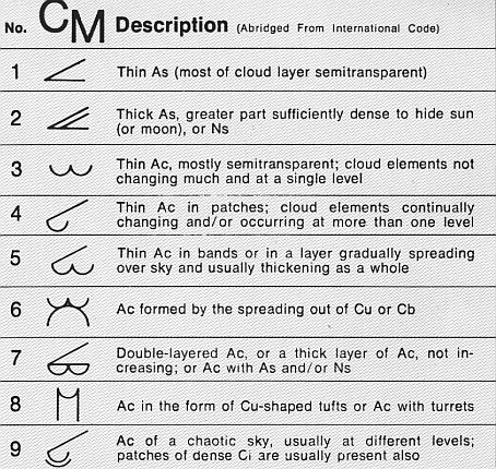
Altocumulus (From Latin ''Altus'', "high", ''cumulus'', "heaped") is a middle-altitude cloud genus that belongs mainly to the ''stratocumuliform'' physical category characterized by globular masses or rolls in layers or patches, the individual elements being larger and darker than those of cirrocumulus and smaller than those of stratocumulus. However, if the layers become tufted in appearance due to increased airmass instability, then the altocumulus clouds become more purely ''cumuliform'' in structure. Like other cumuliform and stratocumuliform clouds, altocumulus signifies convection. A sheet of partially conjoined altocumulus perlucidus is sometimes found preceding a weakening warm front, where the altostratus is starting to fragment, resulting in patches of altocumulus perlucidus between the areas of altostratus. Altocumulus is also commonly found between the warm and cold fronts in a depression, although this is often hidden by lower clouds. Towering altocumulus, known as a ... [...More Info...] [...Related Items...] OR: [Wikipedia] [Google] [Baidu] |
Stratocumulus Volutus Cloud
Stratocumulus volutus is a rare species of stratocumulus cloud, typically forming alone. Volutus is translated from Latin, meaning revolve, being described as a roll cloud. Stratocumulus volutus clouds are low-level clouds, forming below 2,000 meters (6,600 feet). Volutus clouds are much more common in the form of stratocumulus, as opposed to altocumulus volutus. Stratocumulus volutus clouds are not severe, and may only bring several minutes of rain. Alternatively, stratocumulus volutus clouds may form with numerous layers, contradicting the usual rounded form. See also * List of cloud types * Stratocumulus cloud * Cumulus cloud * Roll cloud An arcus cloud is a low, horizontal cloud formation, usually appearing as an accessory cloud to a cumulonimbus. Roll clouds and shelf clouds are the two main types of arcus clouds. They most frequently form along the leading edge or gust fronts o ... References Clouds Cumulus Stratus {{Cloud-stub ... [...More Info...] [...Related Items...] OR: [Wikipedia] [Google] [Baidu] |
Thunderstorm
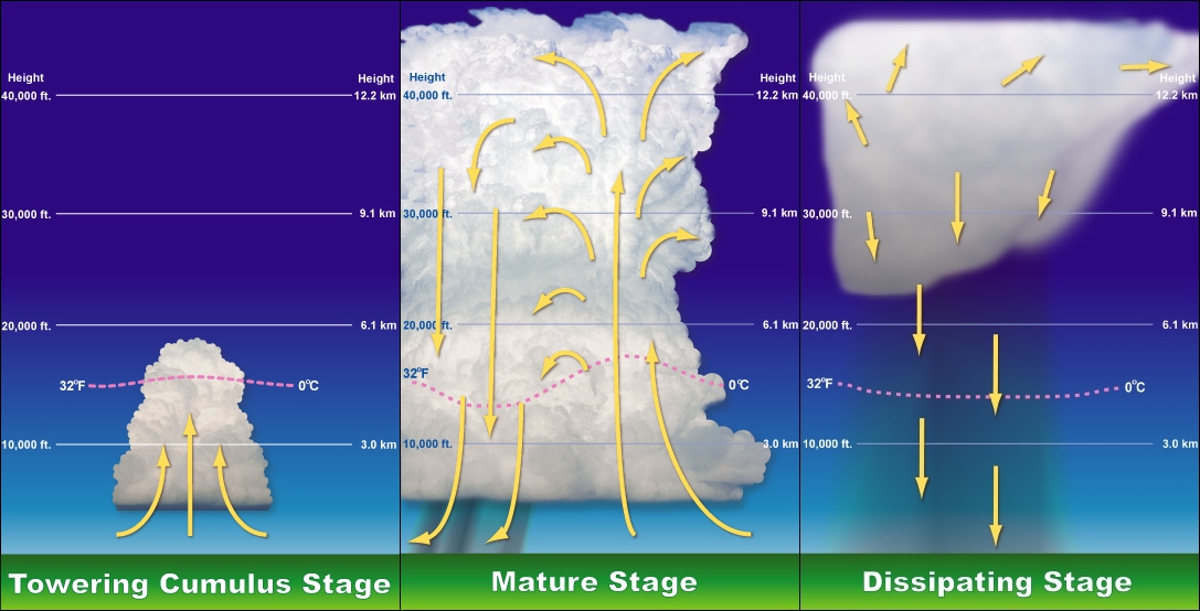
A thunderstorm, also known as an electrical storm or a lightning storm, is a storm characterized by the presence of lightning and its acoustic effect on the Earth's atmosphere, known as thunder. Relatively weak thunderstorms are sometimes called thundershowers. Thunderstorms occur in a type of cloud known as a cumulonimbus. They are usually accompanied by strong winds and often produce heavy rain and sometimes snow, sleet, or hail, but some thunderstorms produce little precipitation or no precipitation at all. Thunderstorms may line up in a series or become a rainband, known as a squall line. Strong or severe thunderstorms include some of the most dangerous weather phenomena, including large hail, strong winds, and tornadoes. Some of the most persistent severe thunderstorms, known as supercells, rotate as do cyclones. While most thunderstorms move with the mean wind flow through the layer of the troposphere that they occupy, vertical wind shear sometimes causes a de ... [...More Info...] [...Related Items...] OR: [Wikipedia] [Google] [Baidu] |
Arcus Cloud
An arcus cloud is a low, horizontal cloud formation, usually appearing as an accessory cloud to a cumulonimbus. Roll clouds and shelf clouds are the two main types of arcus clouds. They most frequently form along the leading edge or gust fronts of thunderstorms; some of the most dramatic arcus formations mark the gust fronts of derecho-producing convective systems. Roll clouds may also arise in the absence of thunderstorms, forming along the shallow cold air currents of some sea breeze boundaries and cold fronts. Types Shelf cloud A shelf cloud is a low, horizontal, wedge-shaped arcus cloud. A shelf cloud is attached to the base of the parent cloud, which is usually a thunderstorm cumulonimbus, but could form on any type of convective clouds. Rising cloud motion can often be seen in the leading (outer) part of the shelf cloud, while the underside can often appear as turbulent and wind-torn. Cool, sinking air from a storm cloud's downdraft spreads out across the land surface ... [...More Info...] [...Related Items...] OR: [Wikipedia] [Google] [Baidu] |
Wind Shear
Wind shear (or windshear), sometimes referred to as wind gradient, is a difference in wind speed and/or direction over a relatively short distance in the atmosphere. Atmospheric wind shear is normally described as either vertical or horizontal wind shear. Vertical wind shear is a change in wind speed or direction with a change in altitude. Horizontal wind shear is a change in wind speed with a change in lateral position for a given altitude. Wind shear is a microscale meteorological phenomenon occurring over a very small distance, but it can be associated with mesoscale or synoptic scale weather features such as squall lines and cold fronts. It is commonly observed near microbursts and downbursts caused by thunderstorms, fronts, areas of locally higher low-level winds referred to as low-level jets, near mountains, radiation inversions that occur due to clear skies and calm winds, buildings, wind turbines, and sailboats. Wind shear has significant effects on the control of a ... [...More Info...] [...Related Items...] OR: [Wikipedia] [Google] [Baidu] |


