|
Alderman's Ford Regional Park
Alderman's Ford Preserve, is a preserve and park in Hillsborough County, Florida, in the United States. The park has two public access points for automobiles, from Thompson Road and from Florida State Road 39 as well as numerous access points for horse, foot or canoe access only. Eight miles of equestrian trails are located along the southern portion of the park, which borders Alafia River State Park roughly along the border of Jameson Road. A three mile long hiking loop over the Alafia River The Alafia River is long, with a watershed of in Hillsborough County, Florida, United States, flowing into Tampa Bay. The watershed contains ten named lakes and ponds, and 29 named rivers, streams and canals. During the rainy season, excess ..., a baseball park, picknicking and canoe rental facilities can be accessed at the Highway 39 entrance. History In 1893 Hillsborough County contracted B. C. West to build a bridge over the Alafia at Alderman's Ford at a price of $300, but the bri ... [...More Info...] [...Related Items...] OR: [Wikipedia] [Google] [Baidu] |
Lithia, Florida
Lithia is an unincorporated area, unincorporated community in Hillsborough County, Florida, United States. It is a suburb of Tampa, Florida, Tampa. The ZIP codes are 33547, 33596, and the area code is Area code 813, 813. It is part of the census-designated place (CDP) of Fish Hawk, Florida, Fish Hawk. Lithia is home to the Alafia River Corridor and Chito Branch Reserve. Description Lithia is a small unincorporated community and home to Lithia Springs Regional Park, Alderman's Ford Regional Park, and the C. W. Bill Young Regional Reservoir, C.W. Bill Young Reservoir. The elevation ranges from less than above sea level at Lithia Springs to south of the post office. The community has a rich history in agriculture, saw mills, and phosphate mining. In the late 1990s, Newland Communities purchased to develop FishHawk, Florida, Fishhawk Ranch. Fishhawk Trails was developed by another company, and more public works and retail stores are currently in development. History Prior to ... [...More Info...] [...Related Items...] OR: [Wikipedia] [Google] [Baidu] |
Hillsborough County, Florida
Hillsborough County is located in the west central portion of the U.S. state of Florida. In the 2020 census, the population was 1,459,762, making it the fourth-most populous county in Florida and the most populous county outside the Miami metropolitan area. A 2021 estimate has the population of Hillsborough County at 1,512,070 people with a yearly growth rate of 1.34%, which itself is greater than the populations of 12 states according to their 2019 population estimates. Its county seat and largest city is Tampa, Florida, Tampa. Hillsborough County is part of the Tampa–St. Petersburg, Florida, St. Petersburg–Clearwater, Florida, Clearwater Tampa Bay Area, Metropolitan Statistical Area. History Hillsborough County was created on January 25, 1834, from Alachua County, Florida, Alachua and Monroe County, Florida, Monroe Counties, during the Florida Territory, U.S. territorial period (1822–1845). The new county was named for Wills Hill, 1st Marquess of Downshire, Wills Hill ... [...More Info...] [...Related Items...] OR: [Wikipedia] [Google] [Baidu] |
Florida
Florida is a state located in the Southeastern region of the United States. Florida is bordered to the west by the Gulf of Mexico, to the northwest by Alabama, to the north by Georgia, to the east by the Bahamas and Atlantic Ocean, and to the south by the Straits of Florida and Cuba; it is the only state that borders both the Gulf of Mexico and the Atlantic Ocean. Spanning , Florida ranks 22nd in area among the 50 states, and with a population of over 21 million, it is the third-most populous. The state capital is Tallahassee, and the most populous city is Jacksonville. The Miami metropolitan area, with a population of almost 6.2 million, is the most populous urban area in Florida and the ninth-most populous in the United States; other urban conurbations with over one million people are Tampa Bay, Orlando, and Jacksonville. Various Native American groups have inhabited Florida for at least 14,000 years. In 1513, Spanish explorer Juan Ponce de León became the first k ... [...More Info...] [...Related Items...] OR: [Wikipedia] [Google] [Baidu] |
United States
The United States of America (U.S.A. or USA), commonly known as the United States (U.S. or US) or America, is a country primarily located in North America. It consists of 50 states, a federal district, five major unincorporated territories, nine Minor Outlying Islands, and 326 Indian reservations. The United States is also in free association with three Pacific Island sovereign states: the Federated States of Micronesia, the Marshall Islands, and the Republic of Palau. It is the world's third-largest country by both land and total area. It shares land borders with Canada to its north and with Mexico to its south and has maritime borders with the Bahamas, Cuba, Russia, and other nations. With a population of over 333 million, it is the most populous country in the Americas and the third most populous in the world. The national capital of the United States is Washington, D.C. and its most populous city and principal financial center is New York City. Paleo-Americ ... [...More Info...] [...Related Items...] OR: [Wikipedia] [Google] [Baidu] |
Florida State Road 39
State Road 39 (SR 39) is a north–south state highway in eastern Pasco and Hillsborough County, Florida, United States. Between Plant City and Zephyrhills, the road is named Paul S. Buchman Highway. North of Zephyrhills, Florida the road is a secret state designation for U.S. Route 301 until the southern terminus of the concurrency with U.S. Route 98 south of Dade City, Florida. Route description Hillsborough County State Road 39 begins at the SR 60 and County Road 39 in Hopewell. The road enters the Plant City Limits at Trapnell Road. An overhead sign gantry points to a truck detour as the road approaches West Alexander Street, although East Alexander Street continues as a four-lane divided highway toward Jim Johnson Road. It's at this intersection where SR 39 makes a left turn while James L. Redman Parkway continues as State Road 39A. The route continues west until it makes a curve between West Maki Road and Mud Lake Road just before passing by the Florida Heart Ins ... [...More Info...] [...Related Items...] OR: [Wikipedia] [Google] [Baidu] |
Alafia River State Park
Alafia River State Park is a Florida State Park, located near Picnic in Hillsborough County in central Florida, 17 miles southeast of Tampa on County Road 39. Even before it became a park, the area, and particularly Hurrah Lake, was the center of leisure activities since the early 1880s. History Phosphate mining began in the area in the 19th century. At its peak the Lonesome Mine was owned by American Cyanamid and then its subsidiary Brewster Phosphates, who excavated the area with draglines until it was no longer commercially profitable to do so. In 1993, Brewster Phosphates including the Lonesome Mine was transferred from American Cyanamid to Cytec Industries. In 1996, Cytec donated the land to the state to be used as a park in perpetuity. Some of the topographical changes caused by mining have been reclaimed, but others, including the features known as the Old Agrico Pits, persist. Some of these were shaped into small lakes during reclamation efforts by Brewster Phosphates un ... [...More Info...] [...Related Items...] OR: [Wikipedia] [Google] [Baidu] |
Alafia River
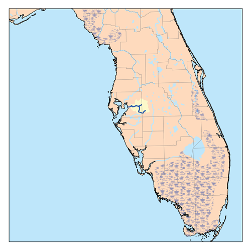
The Alafia River is long, with a watershed of in Hillsborough County, Florida, United States, flowing into Tampa Bay. The watershed contains ten named lakes and ponds, and 29 named rivers, streams and canals. During the rainy season, excess water is pumped to the new C.W. Bill Young Regional Reservoir, which opened in 2005. The river is formed by two prongs. The north prong starts south of Mulberry and runs for 23.9 miles until it meets the south prong in Lithia. The south prong begins south of Bradley Junction and continues for 28.7 miles. The combined river then flows 24.7 miles west into Tampa Bay. History For centuries the Alafia was home to various native tribes, including the Tocobaga. From their settlement at the mouth of the river to their hunting camps upstream, the Indians left traces of their lives and activities. The Mocoso occupied the area around the mouth of the Alafia in the 16th century and were believed to speak Timucuan. In the sixteenth century, the expedit ... [...More Info...] [...Related Items...] OR: [Wikipedia] [Google] [Baidu] |


