|
Agulhas Basin
The Agulhas Basin is an oceanic basin located south of South Africa where the South Atlantic Ocean and south-western Indian Ocean meet. Part of the African Plate, it is bounded by the Agulhas Ridge (part of the Agulhas-Falkland Fracture Zone) to the north and the Southwest Indian Ridge to the south; by the Meteor Rise to the west and the Agulhas Plateau to the east. Numerous bathymetric anomalies hint at the basin's dynamic tectonic history. Geology In a Late Paleocene (59-56 Ma) reconstruction of the opening of the South Atlantic Ocean (i.e. the separation of South America and Africa during the Gondwana break-up) the Meteor Rise lies conjugate to the Islas Orcadas Rise (east of the Falkland Plateau). The separation of the Meteor Rise and the Islas Orcadas Rise marks the beginning of the formation of the Agulhas Basin. The Agulhas Ridge extends from the northern tip of the Meteor Rise towards the Agulhas Bank south of South Africa. The ridge, however, ends abruptly in a s ... [...More Info...] [...Related Items...] OR: [Wikipedia] [Google] [Baidu] |
Agulhas Basin NOAA ''
{{disambig ...
Agulhas (''needles'' in the Portuguese language — or ) may refer to: * Cape Agulhas, the southernmost point of Africa * L'Agulhas, a town near the Cape * Cape Agulhas Lighthouse, located at the Cape * Cape Agulhas Local Municipality, the municipality governing the area around Bredasdorp, including the Cape * Agulhas National Park, a national park protecting areas around Cape Agulhas * The Agulhas Bank, an area of ocean south of the Cape * The Agulhas Current, an ocean current off the east coast of South Africa * South African research ships: : **'' S. A. Agulhas'' **''S. A. Agulhas II ''S. A. Agulhas II'' is a South African icebreaking polar supply and research ship owned by the Department of Environmental Affairs (DEA). She was built in 2012 by STX Finland Rauma shipyard in Rauma, Finland, to replace the ageing '' S. A. Agu ... [...More Info...] [...Related Items...] OR: [Wikipedia] [Google] [Baidu] |
Agulhas Bank
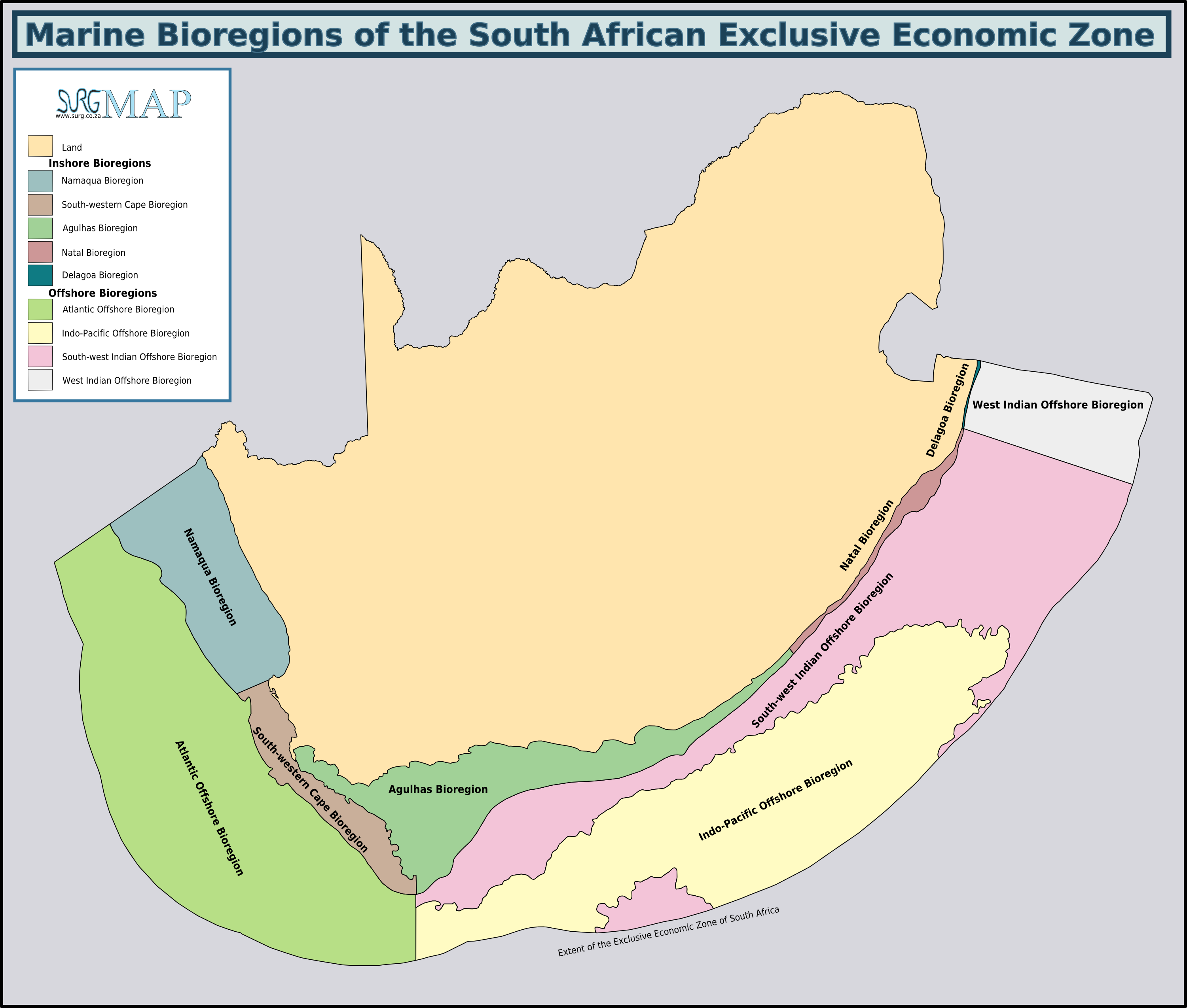
The Agulhas Bank (, from Portuguese for Cape Agulhas, ''Cabo das Agulhas'', "Cape of Needles") is a broad, shallow part of the southern African continental shelf which extends up to south of Cape Agulhas before falling steeply to the abyssal plain. It is the ocean region where the warm Indian Ocean and the cold Atlantic Ocean meet. This convergence leads to treacherous sailing conditions, accounting for numerous wrecked ships in the area over the years. However, the meeting of the oceans here also fuels the nutrient cycle for marine life, making it one of the best fishing grounds in South Africa. Extent and characteristics South African marine ecoregions from the 2011 classification The Agulhas Bank stretches approximately along the African coast, from off Cape Peninsula (18°E) to Port Alfred (26°E), and up to from it. The bank slopes down relatively steeply from the coast to about deep and reaches before dropping steeply to on its southern edge. The shelf spans a ... [...More Info...] [...Related Items...] OR: [Wikipedia] [Google] [Baidu] |
Antarctic Circumpolar Current
The Antarctic Circumpolar Current (ACC) is an ocean current that flows clockwise (as seen from the South Pole) from west to east around Antarctica. An alternative name for the ACC is the West Wind Drift. The ACC is the dominant circulation feature of the Southern Ocean and has a mean transport estimated at 100–150 Sverdrups (Sv, million m3/s), or possibly even higher, making it the largest ocean current. The current is circumpolar due to the lack of any landmass connecting with Antarctica and this keeps warm ocean waters away from Antarctica, enabling that continent to maintain its huge ice sheet. Associated with the Circumpolar Current is the Antarctic Convergence, where the cold Antarctic waters meet the warmer waters of the subantarctic, creating a zone of upwelling nutrients. These nurture high levels of phytoplankton with associated copepods and krill, and resultant foodchains supporting fish, whales, seals, penguins, albatrosses, and a wealth of other species. The ... [...More Info...] [...Related Items...] OR: [Wikipedia] [Google] [Baidu] |
Drake Passage
The Drake Passage (referred to as Mar de Hoces Hoces Sea"in Spanish-speaking countries) is the body of water between South America's Cape Horn, Chile and the South Shetland Islands of Antarctica. It connects the southwestern part of the Atlantic Ocean (Scotia Sea) with the southeastern part of the Pacific Ocean and extends into the Southern Ocean. The Drake Passage is considered one of the most treacherous voyages for ships to make. Currents at its latitude meet no resistance from any landmass, and waves top , hence its reputation as "the most powerful convergence of seas". As the Drake Passage is the narrowest passage around Antarctica, its existence and shape strongly influence the circulation of water around Antarctica and the global oceanic circulation, as well as the global climate. The bathymetry of the Drake Passage plays an important role in the global mixing of oceanic water. It is one of the most treacherous bodies of water on earth. History Sailing south from the ... [...More Info...] [...Related Items...] OR: [Wikipedia] [Google] [Baidu] |
Atlantic Meridional Overturning Circulation
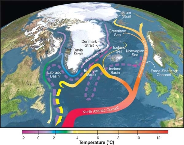
The Atlantic meridional overturning circulation (AMOC) is part of a global thermohaline circulation in the oceans and is the zonally integrated component of surface and deep currents in the Atlantic Ocean. It is characterized by a northward flow of warm, salty water in the upper layers of the Atlantic, and a southward flow of colder, deep waters. These "limbs" are linked by regions of overturning in the Nordic and Labrador Seas and the Southern Ocean, although the extent of overturning in the Labrador Sea is disputed. The AMOC is an important component of the Earth's climate system, and is a result of both atmospheric and thermohaline drivers. Climate change has the potential to weaken the AMOC through increases in ocean heat content and elevated freshwater flows from the melting ice sheets. Oceanographic reconstructions generally suggest that the AMOC is already weaker than it was before the Industrial Revolution, although there is a robust debate over the role of climate cha ... [...More Info...] [...Related Items...] OR: [Wikipedia] [Google] [Baidu] |
Cyclonic
In meteorology, a cyclone () is a large air mass that rotates around a strong center of low atmospheric pressure, counterclockwise in the Northern Hemisphere and clockwise in the Southern Hemisphere as viewed from above (opposite to an anticyclone). Cyclones are characterized by inward-spiraling winds that rotate about a zone of low pressure. The largest low-pressure systems are polar vortices and extratropical cyclones of the largest scale (the synoptic scale). Warm-core cyclones such as tropical cyclones and subtropical cyclones also lie within the synoptic scale. Mesocyclones, tornadoes, and dust devils lie within smaller mesoscale. Upper level cyclones can exist without the presence of a surface low, and can pinch off from the base of the tropical upper tropospheric trough during the summer months in the Northern Hemisphere. Cyclones have also been seen on extraterrestrial planets, such as Mars, Jupiter, and Neptune. Cyclogenesis is the process of cyclone formation and ... [...More Info...] [...Related Items...] OR: [Wikipedia] [Google] [Baidu] |
Mesoscale Meteorology
Mesoscale meteorology is the study of weather systems smaller than synoptic scale systems but larger than Microscale meteorology, microscale and storm-scale cumulus systems. Horizontal dimensions generally range from around 5 kilometers to several hundred kilometers. Examples of mesoscale weather systems are sea breezes, squall lines, and mesoscale convective complexes. Vertical velocity often equals or exceeds horizontal velocities in mesoscale meteorological systems due to nonhydrostatic processes such as buoyant acceleration of a rising thermal or acceleration through a narrow mountain pass. Subclasses Mesoscale Meteorology is divided into these subclasses: * Meso-alpha 200–2000 km scale of phenomena like fronts, squall lines, mesoscale convective systems (MCS), tropical cyclones at the edge of synoptic scale * Meso-beta 20–200 km scale of phenomena like sea breezes, lake effect snow storms * Meso-gamma 2–20 km scale of phenomena like thunderstorm convectio ... [...More Info...] [...Related Items...] OR: [Wikipedia] [Google] [Baidu] |
Eddy (fluid Dynamics)
In fluid dynamics, an eddy is the swirling of a fluid and the reverse current created when the fluid is in a turbulent flow regime. The moving fluid creates a space devoid of downstream-flowing fluid on the downstream side of the object. Fluid behind the obstacle flows into the void creating a swirl of fluid on each edge of the obstacle, followed by a short reverse flow of fluid behind the obstacle flowing upstream, toward the back of the obstacle. This phenomenon is naturally observed behind large emergent rocks in swift-flowing rivers. An eddy is a movement of fluid that deviates from the general flow of the fluid. An example for an eddy is a vortex which produces such deviation. However, there are other types of eddies that are not simple vortices. For example, a Rossby wave is an eddy which is an undulation that is a deviation from mean flow, but doesn't have the local closed streamlines of a vortex. Swirl and eddies in engineering The propensity of a fluid to swirl is used ... [...More Info...] [...Related Items...] OR: [Wikipedia] [Google] [Baidu] |
Retroflect
Retroflection is the movement of an ocean current that doubles back on itself. Usage history More commonly used to describe the way the mammalian intestine or uterus might turn back on itself, retroflection was first used in an oceanographic sense in 1970 by South African oceanographer Nils Bang, to describe the Agulhas Current which curves on itself at the southern tip of Africa to become the Aghulhas Return Current. Bang credited the inspiration for the metaphor to his wife, Alison Coombe Bang, a nursing sister, who mentioned the term during her midwifery studies. Bang's research, through the University of Cape Town, was done on a limited budget and with rudimentary equipment,Sciendaba, Vol XII No 48, 15 December 1977 yet his studies using closely spaced bathythermograph readings, were later corroborated by satellite thermal imagery. The term was then revived and is now common parlance among oceanographers. The Agulhas current's retroflection is now key to an understanding of its ... [...More Info...] [...Related Items...] OR: [Wikipedia] [Google] [Baidu] |
Agulhas Current
The Agulhas Current () is the western boundary current of the southwest Indian Ocean. It flows south along the east coast of Africa from 27°S to 40°S. It is narrow, swift and strong. It is suggested that it is the largest western boundary current in the world ocean, with an estimated net transport of 70 sverdrups (70 million cubic metres per second), as western boundary currents at comparable latitudes transport less — Brazil Current (16.2 Sv), Gulf Stream (34 Sv), Kuroshio (42 Sv). Physical properties The sources of the Agulhas Current are the East Madagascar Current (25 Sv), the Mozambique Current (5 Sv) and a recirculated part of the south-west Indian subgyre south of Madagascar (35 Sv). The net transport of the Agulhas Current is estimated as 100 Sv. The flow of the Agulhas Current is directed by the topography. The current follows the continental shelf from Maputo to the tip of the Agulhas Bank (250 km south of Cape Agulhas). Here the momentum of the current ... [...More Info...] [...Related Items...] OR: [Wikipedia] [Google] [Baidu] |
Large Igneous Province
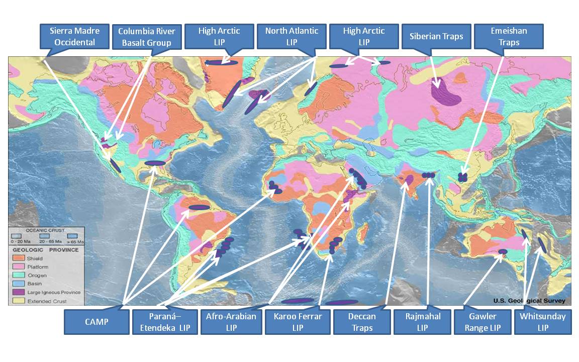
A large igneous province (LIP) is an extremely large accumulation of igneous rocks, including intrusive (sills, dikes) and extrusive (lava flows, tephra deposits), arising when magma travels through the crust towards the surface. The formation of LIPs is variously attributed to mantle plumes or to processes associated with divergent plate tectonics. The formation of some of the LIPs in the past 500 million years coincide in time with mass extinctions and rapid climatic changes, which has led to numerous hypotheses about causal relationships. LIPs are fundamentally different from any other currently active volcanoes or volcanic systems. Definition In 1992 researchers first used the term ''large igneous province'' to describe very large accumulations—areas greater than 100,000 square kilometers (approximately the area of Iceland)—of mafic igneous rocks that were erupted or emplaced at depth within an extremely short geological time interval: a few million years or less. Maf ... [...More Info...] [...Related Items...] OR: [Wikipedia] [Google] [Baidu] |


