|
ARkStorm
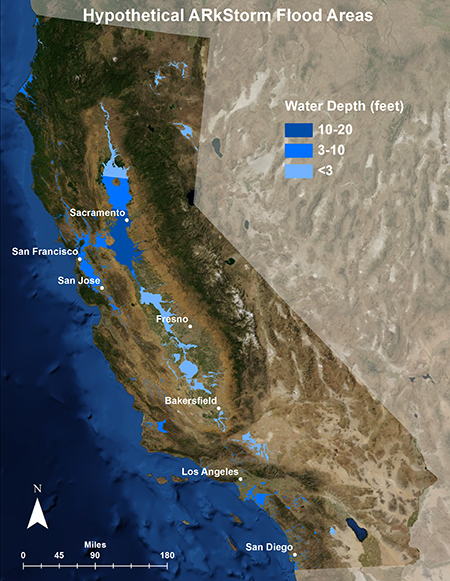
An ARkStorm (for Atmospheric River 1,000) is a "megastorm" proposed scenario based on repeated historical occurrences of atmospheric rivers and other major rain events first developed and published by the Multi-Hazards Demonstration Project (MHDP) of the United States Geological Survey (USGS) in 2010 and updated as ARkStorm 2.0 in 2022. ARkStorm 1.0 (2010 Study) The ARkStorm 1.0 scenario describes an extreme storm that devastates much of California, causing up to $725 billion in losses (mostly due to flooding), and affecting a quarter of California's homes. The scenario projects impacts of a storm that would be significantly less intense (25 days of rain) than the California storms that occurred between December 1861 and January 1862 (43 days). That event dumped nearly of rain in parts of California. USGS sediment research in the San Francisco Bay Area, Santa Barbara Basin, Sacramento Valley, and the Klamath Mountain region found that "megastorms" have occurred in the ... [...More Info...] [...Related Items...] OR: [Wikipedia] [Google] [Baidu] |
Great Flood Of 1862
The Great Flood of 1862 was the largest flood in the recorded history of Oregon, Nevada, and California, occurring from December 1861 to January 1862. It was preceded by weeks of continuous rains and snows in the very high elevations that began in Oregon in November 1861 and continued into January 1862. This was followed by a record amount of rain from January 9–12, and contributed to a flood that extended from the Columbia River southward in western Oregon, and through California to San Diego, and extended as far inland as Idaho in the Washington Territory, Nevada and Utah in the Utah Territory, and Arizona in the western New Mexico Territory. The event dumped an equivalent of of water in California, in the form of rain and snow, over a period of 43 days. Immense snowfalls in the mountains of far western North America caused more flooding in Idaho, Arizona, New Mexico, as well as in Baja California and Sonora, Mexico the following spring and summer, as the snow melted. The even ... [...More Info...] [...Related Items...] OR: [Wikipedia] [Google] [Baidu] |
California Flood Of 1605
The California flood of 1605 was a massive flood that submerged large portions of present-day California (once known as Alta California). The megaflood was a result of sustained major rain storms across the region, enhanced by an unusually powerful atmospheric river. The flooding affected the indigenous peoples of California, in pre-industrial advancement populations. In addition to this event, geologic evidence indicates that other "megafloods" occurred in the California region in the following years A.D.: 212, 440, 603, 1029, c. 1300, 1418, 1750, 1810, and 1861–62. United States Geological Survey sediment research revealed that the 1605 flood deposited a layer of silt two inches thick at the Santa Barbara basin, indicating that it was the worst flood event of the past 2,000 years, being at least 50% more powerful than any of the others recorded based on geological evidence. The United States Geological Survey has developed a hypothetical scenario, known as the "ARkStorm", tha ... [...More Info...] [...Related Items...] OR: [Wikipedia] [Google] [Baidu] |
Pineapple Express
Pineapple Express is a non-technical term for a meteorological phenomenon characterized by a strong and persistent large-scale flow of warm moist air, and the associated heavy precipitation both in the waters immediately northeast of the Hawaiian Islands and extending northeast to any location along the Pacific coast of North America. A Pineapple Express is an example of an atmospheric river, which is a more general term for such relatively narrow corridors of enhanced water vapor transport at mid-latitudes around the world. Causes and effects A ''Pineapple Express'' is driven by a strong, southern branch of the polar jet stream and is marked by the presence of a surface frontal boundary which is typically either slow or stationary, with waves of low pressure traveling along its length. Each of these low-pressure systems brings enhanced rainfall. The conditions are often created by the Madden–Julian oscillation, an equatorial rainfall pattern which feeds its moisture into t ... [...More Info...] [...Related Items...] OR: [Wikipedia] [Google] [Baidu] |
Central Valley (California)
The Central Valley is a broad, elongated, flat valley that dominates the interior of California. It is wide and runs approximately from north-northwest to south-southeast, inland from and parallel to the Pacific coast of the state. It covers approximately , about 11% of California's land area. The valley is bounded by the Coast Ranges The Pacific Coast Ranges (officially gazetted as the Pacific Mountain System in the United States) are the series of mountain ranges that stretch along the West Coast of North America from Alaska south to Northern and Central Mexico. Although th ... to the west and the Sierra Nevada to the east. The Central Valley is a list of regions of California, region known for its agricultural productivity: it provides more than half of the fruits, vegetables, and nuts grown in the United States. More than of the valley are irrigated via reservoirs and canals. The valley hosts many cities, including the state capital Sacramento, California, Sacramento ... [...More Info...] [...Related Items...] OR: [Wikipedia] [Google] [Baidu] |
North American Monsoon
The North American monsoon, variously known as the Southwest monsoon, the Mexican monsoon, the New Mexican monsoon, or the Arizona monsoon is a pattern of pronounced increase in thunderstorms and rainfall over large areas of the southwestern United States and northwestern Mexico, typically occurring between June and mid-September. During the monsoon, thunderstorms are fueled by daytime heating and build up during the late afternoon and early evening. Typically, these storms dissipate by late night, and the next day starts out fair, with the cycle repeating daily. The monsoon typically loses its energy by mid-September when much drier conditions are reestablished over the region. Geographically, the North American monsoon precipitation region is centered over the Sierra Madre Occidental in the Mexican states of Sinaloa, Durango, Sonora and Chihuahua. Mechanism The North American monsoon is a complex weather process that brings moisture from the Gulf of California (and to le ... [...More Info...] [...Related Items...] OR: [Wikipedia] [Google] [Baidu] |
Atmospheric River
An atmospheric river (AR) is a narrow corridor or filament of concentrated moisture in the atmosphere. Other names for this phenomenon are tropical plume, tropical connection, moisture plume, water vapor surge, and cloud band. Atmospheric rivers consist of narrow bands of enhanced water vapor transport, typically along the boundaries between large areas of divergent surface air flow, including some frontal zones in association with extratropical cyclones that form over the oceans. Pineapple Express storms are the most commonly represented and recognized type of atmospheric rivers; the name is due to the warm water vapor plumes originating over the Hawaiian tropics that follow various paths towards western North America, arriving at latitudes from California and the Pacific Northwest to British Columbia and even southeast Alaska. Description The term was originally coined by researchers Reginald Newell and Yong Zhu of the Massachusetts Institute of Technology in the early 199 ... [...More Info...] [...Related Items...] OR: [Wikipedia] [Google] [Baidu] |
Hurricane Katrina
Hurricane Katrina was a destructive Category 5 Atlantic hurricane that caused over 1,800 fatalities and $125 billion in damage in late August 2005, especially in the city of New Orleans and the surrounding areas. It was at the time the costliest tropical cyclone on record and is now tied with 2017's Hurricane Harvey. The storm was the twelfth tropical cyclone, the fifth hurricane, and the third major hurricane of the 2005 Atlantic hurricane season, as well as the fourth-most intense Atlantic hurricane on record to make landfall in the contiguous United States. Katrina originated on August 23, 2005, as a tropical depression from the merger of a tropical wave and the remnants of Tropical Depression Ten. Early the following day, the depression intensified into a tropical storm as it headed generally westward toward Florida, strengthening into a hurricane two hours before making landfall at Hallandale Beach on August 25. After briefly weakening to tropical storm strength o ... [...More Info...] [...Related Items...] OR: [Wikipedia] [Google] [Baidu] |
Natural Disasters In California
Nature, in the broadest sense, is the physical world or universe. "Nature" can refer to the phenomena of the physical world, and also to life in general. The study of nature is a large, if not the only, part of science. Although humans are part of nature, human activity is often understood as a separate category from other natural phenomena. The word ''nature'' is borrowed from the Old French ''nature'' and is derived from the Latin word ''natura'', or "essential qualities, innate disposition", and in ancient times, literally meant "birth". In ancient philosophy, ''natura'' is mostly used as the Latin translation of the Greek word ''physis'' (φύσις), which originally related to the intrinsic characteristics of plants, animals, and other features of the world to develop of their own accord. The concept of nature as a whole, the physical universe, is one of several expansions of the original notion; it began with certain core applications of the word φύσις by pre-Soc ... [...More Info...] [...Related Items...] OR: [Wikipedia] [Google] [Baidu] |
Environment Of California
The environment of California describes results of human habitation of the American State of California. History of environmental action California's Mediterranean climate makes vegetation susceptible to wildfires through the dry summers. Aboriginal Californians used fire to control brush, promote growth of seed-producing plants important to subsistence, and perhaps as an aid to hunting wildlife. These periodic fires kept woodland areas relatively open until 20th century laws curtailed burning in an effort to protect structures. European crops and livestock were introduced with missions along the coast from San Diego to San Francisco Bay through the late 18th and early 19th century. The California Gold Rush caused explosive population growth making San Francisco the only 19th century city west of St. Louis, Missouri.Donley, Allan, Caro, and Patton ''Atlas of California'' (1979) pp.9-19 Water soon became the limiting factor for population growth, and early laws establish ... [...More Info...] [...Related Items...] OR: [Wikipedia] [Google] [Baidu] |
Scientific American
''Scientific American'', informally abbreviated ''SciAm'' or sometimes ''SA'', is an American popular science magazine. Many famous scientists, including Albert Einstein and Nikola Tesla, have contributed articles to it. In print since 1845, it is the oldest continuously published magazine in the United States. ''Scientific American'' is owned by Springer Nature, which in turn is a subsidiary of Holtzbrinck Publishing Group. History ''Scientific American'' was founded by inventor and publisher Rufus Porter (painter), Rufus Porter in 1845 as a four-page weekly newspaper. The first issue of the large format newspaper was released August 28, 1845. Throughout its early years, much emphasis was placed on reports of what was going on at the United States Patent and Trademark Office, U.S. Patent Office. It also reported on a broad range of inventions including perpetual motion machines, an 1860 device for buoying vessels by Abraham Lincoln, and the universal joint which now can be found ... [...More Info...] [...Related Items...] OR: [Wikipedia] [Google] [Baidu] |
Lists Of Floods In The United States
Lists of floods in the United States provide overviews of major floods in the United States. They are organized by time period: before 1901, from 1901 to 2000, and from 2001 to the present. Lists * Floods in the United States before 1901 Floods in the United States before 1900 is a list of flood events that were of significant impact to the country, before 1900. Floods are generally caused by excessive rainfall, excessive snowmelt, and dam failure. Prehistoric events Kankakee Tor ... * Floods in the United States: 1901–2000 * Floods in the United States: 2001–present {{DEFAULTSORT:Floods in the United States ... [...More Info...] [...Related Items...] OR: [Wikipedia] [Google] [Baidu] |


.jpg)
