|
A726
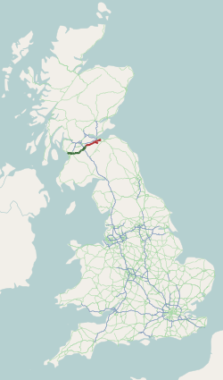
The A726 road in Scotland is a major route with several distinct sections with different characteristics and names; owing to its stages of construction, since 2005 it has two separate parts, the first running between Strathaven in South Lanarkshire and Junction 5 of the M77 motorway south of Newton Mearns in East Renfrewshire via East Kilbride, and the other running between Junction 3 of the M77 and the M898 motorway near the Erskine Bridge, via Paisley and Junction 29 of the M8 motorway near Glasgow International Airport.A726 Strathaven to Erskine Bridge Glasgow Motorway Archive, January 2021 Route Strathaven and East Kilbride The A726's first section begins in the small market town of |
East Kilbride
East Kilbride (; gd, Cille Bhrìghde an Ear ) is the largest town in South Lanarkshire in Scotland and the country's sixth-largest locality by population. It was also designated Scotland's first new town on 6 May 1947. The area lies on a raised plateau to the south of the Cathkin Braes, about southeast of Glasgow and close to the boundary with East Renfrewshire. The town ends close to the White Cart Water to the west and is bounded by the Rotten Calder Water to the east. Immediately to the north of the modern town centre is The Village, the part of East Kilbride that existed before its post-war development into a New Town. East Kilbride is twinned with the town of Ballerup, in Denmark. History and prehistory The earliest-known evidence of occupation in the area dates as far back as the late Neolithic and Early Bronze Age, as archaeological investigation has demonstrated that burial cairns in the district began as ceremonial or ritual sites of burial during the Neolithic, ... [...More Info...] [...Related Items...] OR: [Wikipedia] [Google] [Baidu] |
M8 Motorway (Scotland)
The M8 is the busiest motorway in Scotland and one of the busiest in the United Kingdom. It connects the country's two largest cities, Glasgow and Edinburgh, and serves other large communities including Airdrie, Coatbridge, Greenock, Livingston and Paisley. The motorway is long. A major construction project to build the final section between Newhouse and Baillieston was completed on 30 April 2017. The motorway has one service station, Heart of Scotland Services, previously named Harthill due to its proximity to the village. History With the advent of motorway-building in the United Kingdom in the late 1950s, the M8 was planned as one of a core of new motorways, designed to replace the A8 road as a high-capacity alternative for intercity travel. The motorway was constructed piecemeal in several stages bypassing towns, beginning in 1965 with the opening by Minister of State for Scotland George Willis of the bypass of Harthill. In 1968 the Renfrew Bypass was opened as t ... [...More Info...] [...Related Items...] OR: [Wikipedia] [Google] [Baidu] |
Strathaven
Strathaven (; from gd, Strath Aibhne ) is a historic market town in South Lanarkshire, Scotland and is the largest settlement in Avondale. It is south of Hamilton. The Powmillon Burn runs through the town centre, and joins the Avon Water to the east of the town. The current estimated population is 8,000. The town was granted a royal charter in 1450, making the Town of Strathaven a burgh of barony. The A71, which connects Edinburgh and Irvine, passes through the town. History A Roman road passes close by, on the south side of the Avon Water; it led to the Roman fort at Loudoun Hill near Darvel. The origins of Strathaven Castle are obscure, but it is believed to have been held by the Bairds until after the end of the Wars of Scottish Independence in 1357. It then passed to William Douglas, 1st Earl of Douglas in 1370. The settlement within the lands of Strathaven became a burgh of barony in 1450. The centre of the town is occupied by the market square, formerly a grassed co ... [...More Info...] [...Related Items...] OR: [Wikipedia] [Google] [Baidu] |
A725 Road
The A725 road in Scotland is a major route which is a trunk road dual carriageway for almost its whole length, connecting several of the large towns of North Lanarkshire and South Lanarkshire, linking the M8 and M74 motorways; it has been upgraded frequently since its construction, with the most recent major work completed in 2017. In combination with the A726 road which meets the M77 motorway, it forms a southern and eastern bypass for the city of Glasgow. Route and history Bellshill Bypass The northern section of the A725 begins to the east of Glasgow in Coatbridge town centre where it meets the A89; it runs south through the Whifflet and Shawhead neighbourhoods, then links with the A8 and M8 (Junction 7A) in a complex, partially grade-separated junction at Shawhead and travels south past Bellshill, flanked by two large industrial estates that have a dedicated exit, with additional exits at Belziehill for central Bellshill and Viewpark ( A721), and for Orbiston. This was th ... [...More Info...] [...Related Items...] OR: [Wikipedia] [Google] [Baidu] |
Birniehill
Birniehill is an area of the Scottish new town East Kilbride, in South Lanarkshire. It lies southeast of the Town Centre, south of St Leonards and northeast of The Murray. The northbound exist of Birniehill roundabout (which in common with four others in the centre of East Kilbride has underpasses for pedestrians and cyclists at each corner and a sunken landscaped area at its centre) is the start point of the A725 road (known as the 'Kingsway' within the town) which continues north and then east towards Hamilton and the M74 motorway; the east/west exits of the roundabout are the 'Queensway' (A726) which connects the town to Strathaven further south and to the towns of East Renfrewshire further west. The southbound exist leads on to the site of the National Engineering Laboratories, once home to a small nuclear reactor; the site is better known in current times as the Scottish Enterprise Technology Park. nearby further east is the campus of South Lanarkshire College South Lan ... [...More Info...] [...Related Items...] OR: [Wikipedia] [Google] [Baidu] |
Paisley, Renfrewshire
Paisley ( ; sco, Paisley, gd, Pàislig ) is a large town situated in the west central Lowlands of Scotland. Located north of the Gleniffer Braes, the town borders the city of Glasgow to the east, and straddles the banks of the White Cart Water, a tributary of the River Clyde. Paisley serves as the administrative centre for the Renfrewshire council area, and is the largest town in the historic county of the same name. It is often cited as "Scotland's largest town" and is the fifth largest settlement in the country, although it does not have city status. The town became prominent in the 12th century, with the establishment of Paisley Abbey, an important religious hub which formerly had control over other local churches. By the 19th century, Paisley was a centre of the weaving industry, giving its name to the Paisley shawl and the Paisley pattern. The town's associations with political radicalism were highlighted by its involvement in the Radical War of 1820, with striking ... [...More Info...] [...Related Items...] OR: [Wikipedia] [Google] [Baidu] |
The Murray, East Kilbride
The Murray is a residential area in the new town of East Kilbride, in South Lanarkshire, Scotland; it lies immediately to the south-west of the town centre (access for pedestrians is mainly via underpasses beneath the A726 Queensway), and adjacent to the Westwood, Greenhills and Whitehills neighbourhoods to the west, south-west and south-east respectively. The Murray was the first new town development in the area and as such contains the oldest council housing in the town. However, much of this is currently undergoing renovation to improve its condition. Much of the original housing was paid for by Rolls-Royce, as it was intended as accommodation for the workers attracted to the town by the firm's factory. Among the first generation of children to live there was the actor John Hannah. Like the other original neighbourhoods in East Kilbride, it contains a mix of flats in cuboid-shaped buildings and more traditional tenements individual houses in terraces and semi-detached p ... [...More Info...] [...Related Items...] OR: [Wikipedia] [Google] [Baidu] |
M77 Motorway
The M77 motorway is a motorway in Scotland. It begins in Glasgow at the M8 motorway at Kinning Park, and terminates near Kilmarnock at Fenwick, becoming the A77 dual carriageway. Changes were made in 2005 segregating a lane on the M8 motorway almost as far as the Kingston Bridge, which in January 2006 was extended further onto the bridge itself. It forms the most northerly part of the A77 trunk road which links Glasgow to Stranraer in the South West of Scotland. (The A77 itself continues to Portpatrick in Dumfries and Galloway.) History The original M77 was a short spur route which took traffic from the M8 motorway in the Kinning Park area of Glasgow, ending at a roundabout on Dumbreck Road close to Bellahouston Park, although prior to this there had been an unused spur running to roughly Ibrox telephone exchange on Gower Street. A large number of accidents and pollution problems caused in the suburban towns of Giffnock and Newton Mearns by commuter traffic and hea ... [...More Info...] [...Related Items...] OR: [Wikipedia] [Google] [Baidu] |
Newton Mearns
Newton Mearns ( sco, The Mearns; gd, Baile Ùr na Maoirne ) is a suburban town and the largest settlement in East Renfrewshire, Scotland. It lies southwest of Glasgow City Centre on the main road to Ayrshire, above sea level. It has a population of approximately 26,993, stretching from Whitecraigs and Kirkhill in the northeast to Maidenhill in the southeast, to Westacres and Greenlaw in the west and Capelrig/Patterton in the northwest. It is part of the Greater Glasgow conurbation. Its name derives from being a new town of the Mearns (from Scottish Gaelic "a' Mhaoirne" meaning a stewartry). History Until the 20th century, the land around Newton Mearns was primarily agricultural. Ownership passed from the Pollocks (whose name is perpetuated in the nearby Glasgow housing estate of Pollok) to the Maxwells of Caerlaverock around 1300. It then passed to the Maxwells of Nether Pollok in 1648 and then the Stewarts of Blackhall in 1660. A new turnpike road from Eastwood Toll, n ... [...More Info...] [...Related Items...] OR: [Wikipedia] [Google] [Baidu] |
Erskine
Erskine (, sco, Erskin, gd, Arasgain) is a town in the council area of Renfrewshire, and historic county of the same name, situated in the West Central Lowlands of Scotland. It lies on the southern bank of the River Clyde, providing the lowest crossing to the north bank of the river at the Erskine Bridge, connecting the town to Old Kilpatrick in West Dunbartonshire. Erskine is a commuter town at the western extent of the Greater Glasgow conurbation, bordering Bishopton to the west and Renfrew, Inchinnan, Paisley and Glasgow Airport to the south. Originally a small village settlement, the town has expanded since the 1960s as the site of development as an overspill town, boosting the population to over 15,000. In 2014, it was rated one of the most attractive postcode areas to live in Scotland. History Archaeological evidence states that agricultural activity took place within the area as far back as 3000 BC and it has been inhabited by humans since 1000 BC. The first re ... [...More Info...] [...Related Items...] OR: [Wikipedia] [Google] [Baidu] |
A71 Road
The A71 is a major road in Scotland linking Edinburgh with Lanarkshire and Ayrshire. It adjoins the Livingston Bypass A899. It runs south west from Edinburgh for approximately 70 miles, through Saughton, Wilkieston and south of Livingston, Whitburn and Wishaw, then by way of Overtown, Garrion Bridge, Stonehouse, Strathaven, Darvel, Newmilns, Galston, Hurlford and Kilmarnock to Irvine on the North Ayrshire coast. Formerly a trunk route from the east to the west coast of Scotland it has since been downgraded to a mix of primary and secondary routes. From Edinburgh to Darvel, it is now a secondary route, in a poor state of repair in some places. But, from Darvel to Irvine, it has retained its primary route status. Route Edinburgh to Newmains The A71 almost parallels the M8 between the A720 (Edinburgh City Bypass) and the junction with the A73 at Newmains. It passes through the village of Wilkieston and onto the Mid Calder bypass, which leads the route to the south o ... [...More Info...] [...Related Items...] OR: [Wikipedia] [Google] [Baidu] |
Darnley
Darnley is an area in south-west Glasgow, Scotland, on the A727 just west of Arden (the areas are separated by the M77 motorway although a footbridge connects them). Other nearby neighbourhoods are Priesthill to the north, Southpark Village to the south, and South Nitshill and Parkhouse to the west; there is also a small industrial estate. The closest railway station is . The Brock Burn flows through the area. History The historic estate of Darnley (anciently ''Derneley'', etc.), in Eastwood parish, Renfrewshire, east of Barrhead, was the seat of an ancient barony.Frances Groome, Ordnance Gazetteer of Scotland, 1882-4 In 1356, Robert Stewart, High Steward of Scotland, granted the barony to Sir John Stewart. It remained a possession of this branch of the house of Stewart (known as "Stewart of Darnley"), and in 1460 Sir John Stewart of Darnley (d. 1495) became "Lord Darnley" (a Scottish Lordship of Parliament) and subsequently in 1488 he was created Earl of Lennox (2nd creation ... [...More Info...] [...Related Items...] OR: [Wikipedia] [Google] [Baidu] |
.jpg)


