|
Apaloderma Narina
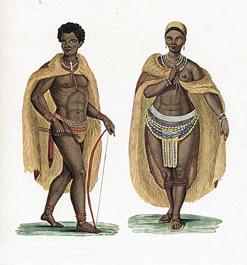
__NOTOC__ The Narina trogon (''Apaloderma narina'') is a largely green and red, medium-sized (32–34 cm long), bird of the family Trogonidae. It is native to forests and woodlands of the Afrotropics. Though it is the most widespread and catholic in habitat choice of the three ''Apaloderma'' species, their numbers are locally depleted due to deforestation. Some populations are sedentary while others undertake regular movements. The species name commemorates Narina, mistress of French ornithologist François Levaillant, whose name he derived from a Khoikhoi word for "flower", as her given name was difficult to pronounce. Description left, 160px, It is sexually dimorphic, with males more brightly coloured. Both sexes have vivid, gingery green upperpart plumage. The tail feathers have a metallic blue-green gloss. The outer three rectices on each side are tipped and fringed white, giving the undertail of perched birds a characteristic white appearance (compare bar-tailed trogon ... [...More Info...] [...Related Items...] OR: [Wikipedia] [Google] [Baidu] |
South Africa
South Africa, officially the Republic of South Africa (RSA), is the southernmost country in Africa. It is bounded to the south by of coastline that stretch along the South Atlantic and Indian Oceans; to the north by the neighbouring countries of Namibia, Botswana, and Zimbabwe; and to the east and northeast by Mozambique and Eswatini. It also completely enclaves the country Lesotho. It is the southernmost country on the mainland of the Old World, and the second-most populous country located entirely south of the equator, after Tanzania. South Africa is a biodiversity hotspot, with unique biomes, plant and animal life. With over 60 million people, the country is the world's 24th-most populous nation and covers an area of . South Africa has three capital cities, with the executive, judicial and legislative branches of government based in Pretoria, Bloemfontein, and Cape Town respectively. The largest city is Johannesburg. About 80% of the population are Black South Afri ... [...More Info...] [...Related Items...] OR: [Wikipedia] [Google] [Baidu] |
Flight Feather
Flight feathers (''Pennae volatus'') are the long, stiff, asymmetrically shaped, but symmetrically paired pennaceous feathers on the wings or tail of a bird; those on the wings are called remiges (), singular remex (), while those on the tail are called rectrices (), singular rectrix (). The primary function of the flight feathers is to aid in the generation of both thrust and lift (force), lift, thereby enabling bird flight, flight. The flight feathers of some birds have evolved to perform additional functions, generally associated with territorial displays, courtship rituals or feeding methods. In some species, these feathers have developed into long showy plumes used in visual courtship displays, while in others they create a sound during display flights. Tiny serrations on the leading edge of their remiges help owls to fly silently (and therefore hunt more successfully), while the extra-stiff rectrices of woodpeckers help them to brace against tree trunks as they hammer on ... [...More Info...] [...Related Items...] OR: [Wikipedia] [Google] [Baidu] |
Knysna
Knysna () is a town with 76,150 inhabitants (2019 mid-year estimates) in the Western Cape province of South Africa. and is one of the destinations on the loosely defined Garden Route tourist route. It lies at 34° 2' 6.3168'' S and 23° 2' 47.2884'' E., and is situated 60 kilometres east of the city of George on the N2 highway, and 33 kilometres west of the Plettenberg Bay on the same road. History Early history Forty fossilised hominid footprints, dating to about 90,000 years ago, along with various other archaeological discoveries suggest that humans have lived in Knysna for well over 300,000 years. The first of these were various San Hunter-gatherer peoples who inhabited most of Southern Africa in paleolithic. The San were gradually displaced and absorbed by south migrating Khoekhoe peoples. Houtunqua (Outeniqua) Khoe The indigenous inhabitants of the Knysna area are a southern Khoekhoe people called the Houtunqua or Outeniqua. Their name means "The People Who Bear Honey" ... [...More Info...] [...Related Items...] OR: [Wikipedia] [Google] [Baidu] |
Eastern Highlands
:''"Eastern Highlands" also refers to Eastern Highlands Province in Papua New Guinea, and part of the Great Dividing Range, Australia.'' The Eastern Highlands, also known as the Manica Highlands, is a mountain range on the border of Zimbabwe and Mozambique. The Eastern Highlands extend north and south for about through Zimbabwe's Manicaland Province and Mozambique's Manica Province. The Highlands are home to the Eastern Zimbabwe montane forest-grassland mosaic ecoregion. The ecoregion includes the portion of the highlands above 1000 meters elevation, including the Inyangani Mountains, Bvumba Mountains, Chimanimani Mountains, Chipinge Uplands, and the isolated Mount Gorongosa further east in Mozambique. The Southern miombo woodlands ecoregion lies at lower elevations east and west of the highlands. The highlands have a cooler, moister climate than the surrounding lowlands, which support distinct communities of plants and animals. The ecoregion is home to several plant commun ... [...More Info...] [...Related Items...] OR: [Wikipedia] [Google] [Baidu] |
Mpala
Mpala is the location of an early Catholic mission in the Belgian Congo. A military station was established at Mpala on the shores of Lake Tanganyika in May 1883. It was transferred to the White Fathers missionaries in 1885. At one time it was hoped that it would form the nucleus of a Christian kingdom in the heart of Africa. However, after a military expedition had to be sent to protect the mission from destruction by local warlords in 1892, civil control returned to the Belgian colonial authorities. The first seminary in the Congo was established at Mpala, and later the mission played an important role in providing practical education to the people of the region. Location Mpala lies on the west shore of Lake Tanganyika in Tanganyika Province, to the north of Moba and south of Kalemie. The station was established at the mouth of the Lufuku River. The lake is about long and across. An 1898 book described it as an inland sea, navigated by a regular flotilla. At that time Albert ... [...More Info...] [...Related Items...] OR: [Wikipedia] [Google] [Baidu] |
Chirinda Forest
The Chirinda Forest Botanical Reserve is situated on the slopes of Mount Selinda, south of Chipinge, in the Chipinge Highlands of Manicaland, Zimbabwe, and is administered by the Forestry Commission. The reserve is situated at between in altitude, and receives some to of annual rainfall. of its higher levels, above , is covered by moist evergreen forest, specifically Zanzibar-Inhambane transitional rain forest, of which it represents the southernmost occurrence. The headwaters of three streams, namely the Zona, Chinyika and Musangazi, drain the two broad highlands which it encloses. The boundaries of the reserve are not strictly enforced, so that cattle grazing and plant harvesting are ongoing. The reserve is surrounded by communal settlements, commercial timber plantations (eucalypts and pines) and small-scale commercial farming units. The naturalist Charles Swynnerton was appointed manager of the nearby Gungunyana farm in 1900, and a number of plant, bird and insect names c ... [...More Info...] [...Related Items...] OR: [Wikipedia] [Google] [Baidu] |
Arabuko Sokoke National Park
The Arabuko Sokoke Forest Reserve is located on the coast of Kenya, 110 km north of Mombasa and is protected as a national Forest Reserve. The Arabuko Sokoke National Park, situated at the north-western edge of the Arabuko Sokoke Forest Reserve, is only a few square kilometres in size and constitutes only a small portion of the latter. Protection The National Park was gazetted only in the late 1980s and in fact straddles the Forest Reserve boundary, with about 50% lying outside the boundary. This outer section actually lies outside an electric elephant fence installed in 2006/7 and is now fully inhabited by local communities to the extent that there is no sign on the ground to show where the National Park begins or ends. The National Park doesn't add any particular protection to the forest which is the largest fragment of coastal forest (420 square km) left in East Africa. The Forest Reserve, on the other hand, is jointly managed by the Kenya Forest Service, Kenya Wildlife ... [...More Info...] [...Related Items...] OR: [Wikipedia] [Google] [Baidu] |
Great Rift Valley, Kenya
The Great Rift Valley is part of an intra-continental ridge system that runs through Kenya from north to south. It is part of the Gregory Rift, the eastern branch of the East African Rift, which starts in Tanzania to the south and continues northward into Ethiopia. It was formed on the "Kenyan Dome" a geographical upwelling created by the interactions of three major tectonics: the Arabian, Nubian, and Somalian plates. In the past, it was seen as part of a "Great Rift Valley" that ran from Madagascar to Syria. Most of the valley falls within the former Rift Valley Province. The valley contains the Cherangani Hills and a chain of volcanoes, some of which are still active. The climate is mild, with temperatures usually below . Most rain falls during the March–June and October–November periods. The Tugen Hills to the west of Lake Baringo contain fossils preserved in lava flows from the period 14 to 4 million years ago. The relics of many hominids, ancestors of humans, have been ... [...More Info...] [...Related Items...] OR: [Wikipedia] [Google] [Baidu] |
Tree Hollow
A tree hollow or tree hole is a semi-enclosed cavity which has naturally formed in the trunk or branch of a tree. They are found mainly in old trees, whether living or not. Hollows form in many species of trees, and are a prominent feature of natural forests and woodlands, and act as a resource or habitat for a number of vertebrate and invertebrate animals. Hollows may form as the result of physiological stress from natural forces causing the excavating and exposure of the heartwood. Forces may include wind, fire, heat, lightning, rain, attack from insects (such as ants or beetles), bacteria, or fungi. Also, trees may self-prune, dropping lower branches as they reach maturity, exposing the area where the branch was attached. Many animals further develop the hollows using instruments such as their beak, teeth or claws. The size of hollows may depend on the age of the tree. For example, eucalypts develop hollows at all ages, but only from when the trees are 120 years old do they f ... [...More Info...] [...Related Items...] OR: [Wikipedia] [Google] [Baidu] |
East Africa
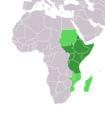
East Africa, Eastern Africa, or East of Africa, is the eastern subregion of the African continent. In the United Nations Statistics Division scheme of geographic regions, 10-11-(16*) territories make up Eastern Africa: Due to the historical Omani Empire and colonial territories of the British East Africa Protectorate and German East Africa, the term ''East Africa'' is often (especially in the English language) used to specifically refer to the area now comprising the three countries of Kenya, Tanzania, and Uganda. However, this has never been the convention in many other languages, where the term generally had a wider, strictly geographic context and therefore typically included Djibouti, Eritrea, Ethiopia, and Somalia.Somaliland is not included in the United Nations geoscheme, as it is internationally recognized as a part of Somalia. *Tanzania, Kenya, Uganda, Rwanda, Burundi, Democratic Republic of Congo and South Sudan are members of the East African Community. The firs ... [...More Info...] [...Related Items...] OR: [Wikipedia] [Google] [Baidu] |
Ethiopia
Ethiopia, , om, Itiyoophiyaa, so, Itoobiya, ti, ኢትዮጵያ, Ítiyop'iya, aa, Itiyoppiya officially the Federal Democratic Republic of Ethiopia, is a landlocked country in the Horn of Africa. It shares borders with Eritrea to the north, Djibouti to the northeast, Somalia to the east and northeast, Kenya to the south, South Sudan to the west, and Sudan to the northwest. Ethiopia has a total area of . As of 2022, it is home to around 113.5 million inhabitants, making it the 13th-most populous country in the world and the 2nd-most populous in Africa after Nigeria. The national capital and largest city, Addis Ababa, lies several kilometres west of the East African Rift that splits the country into the African and Somali tectonic plates. Anatomically modern humans emerged from modern-day Ethiopia and set out to the Near East and elsewhere in the Middle Paleolithic period. Southwestern Ethiopia has been proposed as a possible homeland of the Afroasiatic langua ... [...More Info...] [...Related Items...] OR: [Wikipedia] [Google] [Baidu] |
%2C_crop.jpg)
.jpg)


.jpg)
