|
Anthony's Nose, Victoria
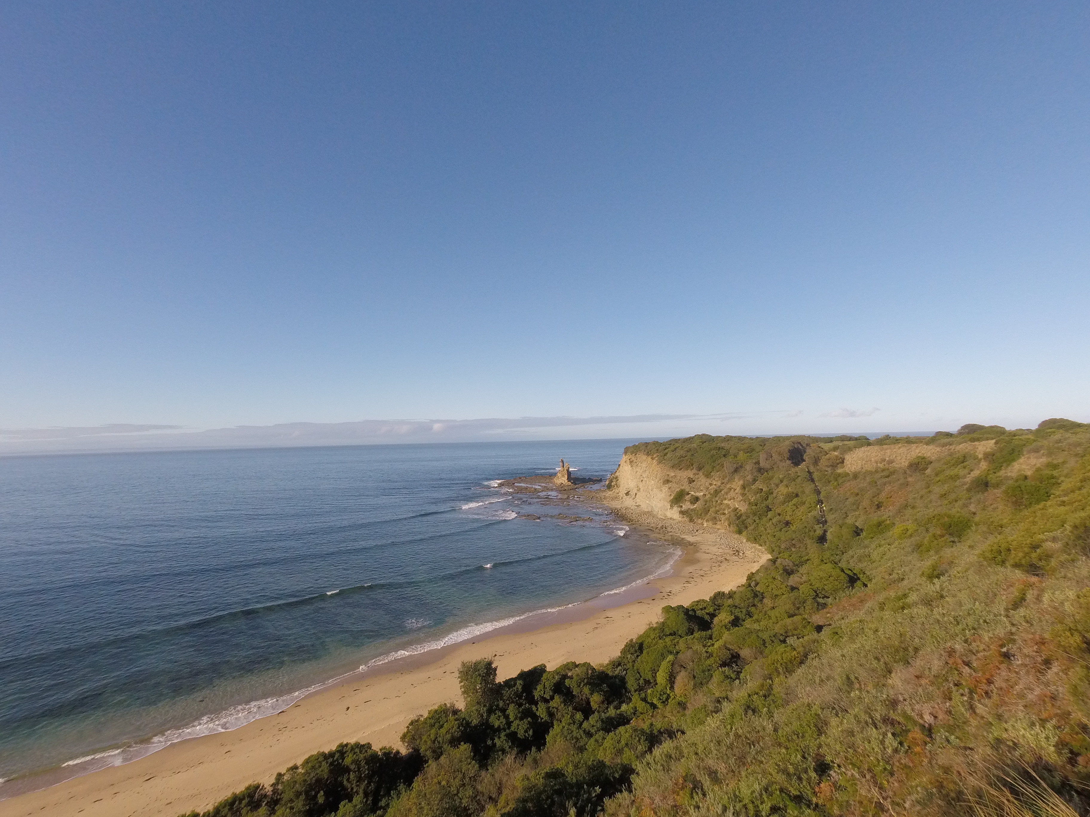
Anthonys Nose is a point, or escarpment located on the southern shore of Port Phillip Bay, between Dromana and McCrae, in Victoria, Australia. History It was named by Charles La Trobe, who became the Superintendent of the Port Phillip District of New South Wales in 1839. He thought that the landform had a strong resemblance to Anthony's Nose (Westchester) on the Hudson River, New York. In the early years of the European settlement of Dromana there were geographical obstacles to travelling by land. A journey from Melbourne to the area meant crossing swamps and streams. Anthony's Nose was the point where Arthur's Seat ended as the mountain "fell steeply to the sea". At high tide a traveller by foot, horse, or wagon found it necessary to wade, ride or drive through the water in order to round the point, as the only road stuck to the coastline. In addition it was difficult at high tide to negotiate the rocks which were then submerged underwater. An 1863 survey map shows th ... [...More Info...] [...Related Items...] OR: [Wikipedia] [Google] [Baidu] |
Escarpment
An escarpment is a steep slope or long cliff that forms as a result of faulting or erosion and separates two relatively level areas having different elevations. The terms ''scarp'' and ''scarp face'' are often used interchangeably with ''escarpment''. Some sources differentiate the two terms, with ''escarpment'' referring to the margin between two landforms, and ''scarp'' referring to a cliff or a steep slope. In this usage an escarpment is a ridge which has a gentle slope on one side and a steep scarp on the other side. More loosely, the term ''scarp'' also describes a zone between a coastal lowland and a continental plateau which shows a marked, abrupt change in elevation caused by coastal erosion at the base of the plateau. Formation and description Scarps are generally formed by one of two processes: either by differential erosion of sedimentary rocks, or by movement of the Earth's crust at a geologic fault. The first process is the more common type: the escarpment is a t ... [...More Info...] [...Related Items...] OR: [Wikipedia] [Google] [Baidu] |
Arthur's Seat, Victoria
Arthurs Seat is a mountainous and small locality on the Mornington Peninsula in Melbourne, Victoria, Australia, about 85 km south east of Melbourne's Central Business District, located within the Shire of Mornington Peninsula local government area. Arthurs Seat recorded a population of 414 at the 2021 census. Arthurs Seat is noted for its exclusivity and the general affluence of the demographics which make up the enclave. The Aboriginal Boonwurrung name for the hill is Wonga. It is a major tourist destination, with stately homes, and due to its natural bushland, sweeping views and man-made attractions. The hill rises to above sea level. The underlying rocks are Devonian granite, bounded to the west by the Selwyn Fault. The vegetation consists of dry open forest of mixed eucalypt species, which was extensively burnt during a bushfire in 1973 and again in 1997. The indigenous vegetation on the north-west face has been heavily infested with noxious weed and much of th ... [...More Info...] [...Related Items...] OR: [Wikipedia] [Google] [Baidu] |
Landforms Of Victoria (Australia)
A landform is a natural or anthropogenic land feature on the solid surface of the Earth or other planetary body. Landforms together make up a given terrain, and their arrangement in the landscape is known as topography. Landforms include hills, mountains, canyons, and valleys, as well as shoreline features such as bays, peninsulas, and seas, including submerged features such as mid-ocean ridges, volcanoes, and the great ocean basins. Physical characteristics Landforms are categorized by characteristic physical attributes such as elevation, slope, orientation, stratification, rock exposure and soil type. Gross physical features or landforms include intuitive elements such as berms, mounds, hills, ridges, cliffs, valleys, rivers, peninsulas, volcanoes, and numerous other structural and size-scaled (e.g. ponds vs. lakes, hills vs. mountains) elements including various kinds of inland and oceanic waterbodies and sub-surface features. Mountains, hills, plateaux, and plains are the fo ... [...More Info...] [...Related Items...] OR: [Wikipedia] [Google] [Baidu] |
Geology Of Victoria
Victoria is an Australian state, situated at the southern end of the Great Dividing Range. The Great Dividing Range stretches along the east coast of the continent and terminates near the Victorian city of Ballarat west of the capital Melbourne, though the nearby Grampians may be considered to be the final part of the range. The highest mountains in Victoria (just under 2,000 m) are the Victorian Alps, located in the northeast of the state. The northwest of the state is mostly Cainozoic rocks while the southeast is primarily made up of Palaeozoic rocks. There have been no discoveries of Precambrian rocks in Victoria. The low flat northwest of the state that borders the Murray River was once the bed of an ancient sea and the land is much afflicted with salinity. Saline drainage from Victorian land is one of the sources of the salinity problem in the Murray–Darling River system. Commercial salt evaporation is undertaken near Swan Hill. Central and western Victoria comprise world ... [...More Info...] [...Related Items...] OR: [Wikipedia] [Google] [Baidu] |
Granite
Granite () is a coarse-grained (phaneritic) intrusive igneous rock composed mostly of quartz, alkali feldspar, and plagioclase. It forms from magma with a high content of silica and alkali metal oxides that slowly cools and solidifies underground. It is common in the continental crust of Earth, where it is found in igneous intrusions. These range in size from dikes only a few centimeters across to batholiths exposed over hundreds of square kilometers. Granite is typical of a larger family of ''granitic rocks'', or ''granitoids'', that are composed mostly of coarse-grained quartz and feldspars in varying proportions. These rocks are classified by the relative percentages of quartz, alkali feldspar, and plagioclase (the QAPF classification), with true granite representing granitic rocks rich in quartz and alkali feldspar. Most granitic rocks also contain mica or amphibole minerals, though a few (known as leucogranites) contain almost no dark minerals. Granite is nearly alway ... [...More Info...] [...Related Items...] OR: [Wikipedia] [Google] [Baidu] |
Rye, Victoria
Rye is a seaside town on the Mornington Peninsula in Melbourne, Victoria, Australia, approximately south-west of Melbourne's Central Business District, located within the Shire of Mornington Peninsula local government area. Rye recorded a population of 9,438 at the 2021 census. Rye's beach, on the eastern side of Port Phillip, is popular with swimmers, fishermen, yachtsmen, and kitesurfers. Its ocean beach (which is not patrolled) is also popular with surfers and divers.Rye Ocean, St Andrews Beach Beachsafe, Surf Life Saving Australia. Rye is in the traditional country of the (Bunurong) people of the |
Yarra River
The Yarra River or historically, the Yarra Yarra River, (Kulin languages: ''Berrern'', ''Birr-arrung'', ''Bay-ray-rung'', ''Birarang'', ''Birrarung'', and ''Wongete'') is a perennial river in south-central Victoria, Australia. The lower stretches of the Yarra are where Victoria's state capital Melbourne was established in 1835, and today metropolitan Greater Melbourne dominates and influences the landscape of its lower reaches. From its source in the Yarra Ranges, it flows west through the Yarra Valley which opens out into plains as it winds its way through Greater Melbourne before emptying into Hobsons Bay in northernmost Port Phillip Bay. The river has been a major food source and meeting place for Indigenous Australians for thousands of years. Shortly after the arrival of European settlers, land clearing forced the remaining Wurundjeri people into neighbouring territories and away from the river. Originally called ''Birrarung'' by the Wurundjeri, the current name was mis ... [...More Info...] [...Related Items...] OR: [Wikipedia] [Google] [Baidu] |
Mornington Peninsula
The Mornington Peninsula is a peninsula located south of Melbourne, Victoria, Australia. It is surrounded by Port Phillip to the west, Western Port to the east and Bass Strait to the south, and is connected to the mainland in the north. Geographically, the peninsula begins its protrusion from the mainland in the area between Pearcedale and an area north of Frankston. The area was originally home to the ''Mayone-bulluk'' and ''Boonwurrung-Balluk'' clans and formed part of the Boonwurrung nation's territory prior to European settlement. Much of the peninsula has been cleared for agriculture and settlements. However, small areas of the native ecology remain in the peninsula's south and west, some of which is protected by the Mornington Peninsula National Park. In 2002, around 180,000 people lived on the peninsula and in nearby areas, most in the built-up towns on its western shorelines which are sometimes regarded as outlying suburbs of greater Melbourne; there is a seasonal po ... [...More Info...] [...Related Items...] OR: [Wikipedia] [Google] [Baidu] |
Nepean Highway
Nepean Highway runs south from St Kilda Junction in Victoria, Australia to Portsea, close to the eastern shore of Port Phillip. It is the primary road route to central Melbourne from Melbourne's southern suburbs. History Originally known as Arthurs Seat Road it was built in the 1850s to provide a road (originally a crude sandy track) from the farms (owned by Jude Roberts) south of Melbourne and link the city with its southern bay settlements and sea defences at Point Nepean. The passing of the ''Highways and Vehicles Act of 1924'' through the Parliament of Victoria provided for the declaration of State Highways, roads two-thirds financed by the State government through the Country Roads Board (later VicRoads). Nepean Highway was declared a State Highway in the 1947/48 financial year, from Glenhuntly Road in Elsternwick via Frankston to Portsea (for a total of 55 miles); before this declaration, the road was referred to as Point Nepean Road. It was named after Point Nepean, i ... [...More Info...] [...Related Items...] OR: [Wikipedia] [Google] [Baidu] |
Boon Wurrung
The Boonwurrung people are an Aboriginal people of the Kulin nation, who are the traditional owners of the land from the Werribee River to Wilsons Promontory in the Australian state of Victoria. Their territory includes part of what is now the city and suburbs of Melbourne. They were called the Western Port or Port Philip tribe by the early settlers, and were in alliance with other tribes in the Kulin nation, having particularly strong ties to the Wurundjeri people. The Registered Aboriginal Party representing the Boonwurrung people is the Bunurong Land Council Aboriginal Corporation. Language Boonwurrung is one of the Kulin languages, and belongs to the Pama-Nyungan language family. The ethnonym occasionally used in early writings to refer to the Bunwurrung, namely ''Bunwurru'', is derived from the word ''bu:n'', meaning "no" and ''wur:u'', signifying either "lip" or "speech". This indicates that the Boonwurrung language may not be spoken outside of their Country - their cl ... [...More Info...] [...Related Items...] OR: [Wikipedia] [Google] [Baidu] |
Georgiana McCrae
Georgiana Huntly McCrae (15 March 1804 – 24 May 1890) was an English-Australian painter and diarist. Early life Born in London, she was the illegitimate daughter of George Gordon, the Marquess of Huntly, son and heir to Alexander, 4th Duke of Gordon. Her mother was Jane Graham, about whom little is known: ‘whether she was a housemaid or a milliner, a singer or an actress, she did not belong to Lord Huntly’s world’. Her father, although he publicly acknowledged her, played little part in her life but he financially supported her mother. Some of her early life was spent time in Scotland, with her first memories of playing with rocks in Newhaven, near Edinburgh. By the end of 1806 she was back in London, where she was baptised on 6 October at St James' Church, Piccadilly. By 1809, Georgiana and her mother had moved to Somers Town, a district of London where she began her education at a convent school. Somers Town was full of French refugees from the French Revolution ... [...More Info...] [...Related Items...] OR: [Wikipedia] [Google] [Baidu] |
Coastline
The coast, also known as the coastline or seashore, is defined as the area where land meets the ocean, or as a line that forms the boundary between the land and the coastline. The Earth has around of coastline. Coasts are important zones in natural Ecosystem, ecosystems, often home to a wide range of biodiversity. On land, they harbor important ecosystems such as freshwater or estuarine Wetland, wetlands, which are important for bird populations and other terrestrial animals. In wave-protected areas they harbor Salt marsh, saltmarshes, Mangrove, mangroves or Seagrass meadow, seagrasses, all of which can provide nursery habitat for finfish, shellfish, and other aquatic species. Rocky shores are usually found along exposed coasts and provide habitat for a wide range of Sessility (motility), sessile animals (e.g. Mussel, mussels, starfish, Barnacle, barnacles) and various kinds of Seaweed, seaweeds. Along Tropics, tropical coasts with clear, nutrient-poor water, Coral reef, coral ... [...More Info...] [...Related Items...] OR: [Wikipedia] [Google] [Baidu] |
.jpg)


.jpg)


