|
Anaku Town
Anaku is one of the administrative divisions of Anambra State, South-Eastern Nigeria. The town lies 6°15' North of the Equator and 6°44' East of the Greenwich Meridian. It is bordered by "Omabala," the native name of the Anambra River, which is a tributary of the River Niger (North), Aguleri, Ezu River (South), Omor and Umuerum communities (East). The town bears the appellation "Ogbe"; which is derived from its linkage with the Benin Empire (1440–1897) of the defunct Bendel State (now Edo State) and Igala Kingdom of Kogi State in Nigeria, which also explains why Anaku is a land of warriors. Although they are Igbo people and the language is Igbo language, Igbo, dialects of the language can be observed in different parts of the town. Anaku is the headquarter and seat of Ayamelum, Ayamelum Local Government Area. It is easily accessible from Onitsha (about 50 km) and Aguleri, Otuocha Aguleri (about 20 km). Regions Anaku is made up of three major villages, several quarte ... [...More Info...] [...Related Items...] OR: [Wikipedia] [Google] [Baidu] |
Flag Of Nigeria
Work toward freedom led to the formation of a national planning committee, which in 1958 named for a competition to choose a national flag. Thousands of designs were submitted, but the flag of equivalent green-white-green flat stripes, green stood for farming and white for unity and peace was chosen. The flag of the Federal Republic of Nigeria was designed in 1959 and first officially hoisted on 1 October 1960. The flag has three vertical bands of green, white, green. The two green stripes represent natural wealth, and the white represents peace and unity. Design The flag is an adaptation of the winning entry from Michael Taiwo Akinkunmi in a competition held in 1959. Akinkunmi was a 23-year-old student at the time he designed the flag. He was studying at Norwood Technical College in London, England, when he saw an advertisement in a newspaper that submissions were being accepted for the design of a new national flag of Nigeria. He submitted a triband design consisting ... [...More Info...] [...Related Items...] OR: [Wikipedia] [Google] [Baidu] |
Ayamelum
Ayamelum is a local government area (LGA) in Anambra state, in the southeastern part of Nigeria with headquarters in Anaku. The towns that make up the local government are Omor, Umueje, Omasi, Igbakwu, Umumbo, Anaku, Umuerum and Ifite Ogwari. Ayamelum’s area is situated at the border between Enugu state and Anambra state. The communities in the area are notable for food production. The LGA has economic and agricultural potential that can generate funds and create employment. Omor in Ayamelum is noted for its rice production. Thus, the community benefits from the Lower Anambra-Imo River Basin Development Authority which enhances its agricultural activities. However, Ayamelum has no access road. The only entrance to the LGA the is Otuocha-Omor-Adani federal road, which has been in a terrible state. This lack of infrastructure prevents residents from taking their food products to towns and cities. Secondary schools Numerous secondary schools are located in Ayamelum: * Communi ... [...More Info...] [...Related Items...] OR: [Wikipedia] [Google] [Baidu] |
Enugu State
Enugu State ( ig, Ȯra Enugu) is a state in the South-East geopolitical zone of Nigeria, bordered to the north by the states of Benue and Kogi, Ebonyi State to the east and southeast, Abia State to the south, and Anambra State to the west. The state takes its name from its capital and largest city, Enugu. Of the 36 states, Enugu is the 29th largest in area and 22nd most populous with an estimated population of over 4.4 million as of 2016. Geographically, the state is divided between the Niger Delta swamp forests in the far south and the drier Guinean forest–savanna mosaic with some savanna in the rest of the state. Other important geographical features are the Udi-Nsukka Plateau and Ekulu River, which flows through the city of Enugu. Modern-day Enugu State has been inhabited for years by various ethnic groups, primarily the Igbo people with minorities of Idoma and Igala peoples in Etteh Uno. In the pre-colonial period, what is now Enugu State was a part of the med ... [...More Info...] [...Related Items...] OR: [Wikipedia] [Google] [Baidu] |
Niger River
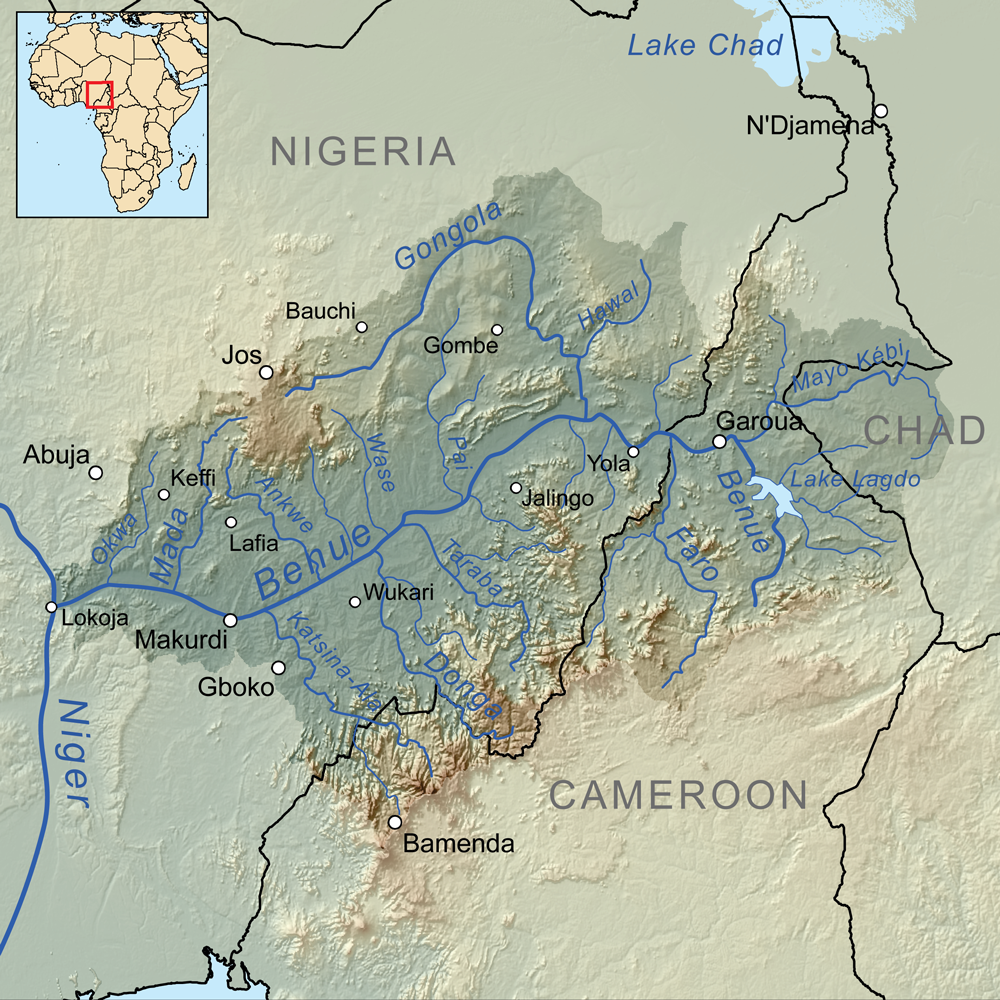
The Niger River ( ; ) is the main river of West Africa, extending about . Its drainage basin is in area. Its source is in the Guinea Highlands in south-eastern Guinea near the Sierra Leone border. It runs in a crescent shape through Mali, Niger, on the border with Benin and then through Nigeria, discharging through a massive delta, known as the Niger Delta (or the Oil Rivers), into the Gulf of Guinea in the Atlantic Ocean. The Niger is the third-longest river in Africa, exceeded by the Nile and the Congo River. Its main tributary is the Benue River. Etymology The Niger has different names in the different languages of the region: * Fula: ''Maayo Jaaliba'' * Manding: ''Jeliba'' or ''Joliba'' "great river" * Tuareg: ''Egerew n-Igerewen'' "river of rivers" * Songhay: ''Isa'' "the river" * Zarma: ''Isa Beeri'' "great river" * Hausa: ''Kwara'' *Nupe: ''Èdù'' * Yoruba: ''Ọya'' "named after the Yoruba goddess Ọya, who is believed to embody the ri ... [...More Info...] [...Related Items...] OR: [Wikipedia] [Google] [Baidu] |
Idah
Idah is a town in Kogi State, Nigeria, on the eastern bank of the Niger River in the middle belt region of Nigeria. It is the headquarter of the Igala Kingdom, and also a Local Government Area with an area of 36 km. Idah had a population of 79,815 at the 2006 census. History The town is the traditional capital of the Igala Kingdom, whose traditional ruler, the Attah Igala, is currently Matthew Alaji Opaluwa Oguche Akpa II. Idah is an important fishing port and Market trading town in Nigeria with an outpost of the Nigeria Navy referred to as Nigeria Navy Ship Lugard. The town as a port of trade was frequented by local and foreign traders who traded agricultural produces and minerals mostly. Bronze rings and Cowries were the predominant currency for trade. Geography Idah, an old river port, lies on the eastern bank of the river Niger at . Economy The town is a major food supplier of Kogi State. It has commercial routes on the river Niger linking Lokoja, the Kogi state cap ... [...More Info...] [...Related Items...] OR: [Wikipedia] [Google] [Baidu] |
Eastern Region, Nigeria
The Eastern Region was an administrative region in Nigeria, dating back originally from the division of the colony Southern Nigeria in 1954. Its first capital was Calabar. The capital was later moved to Enugu and the second capital was Umuahia. The region was officially divided in 1967 into three new states, the East-Central State, Rivers State and South-Eastern State. East-Central State had its capital at Enugu, which is now part of Enugu State. The region had the third-, fourth- and fifth-largest indigenous ethnic groups including Igbo, Ibibio and Ijaw. It was what later became Biafra, which was in rebellion from 1967 to 1970. Geography The Eastern region of Nigeria was geographically located in Southeastern Nigeria. It is bordered by the Niger river in the West and has an administrative and cultural border with the Northern region of Nigeria to the north. The eastern boundary lies between the border of Nigeria and Cameroon and the southern coast is along the Gulf of G ... [...More Info...] [...Related Items...] OR: [Wikipedia] [Google] [Baidu] |
Jukun People (West Africa)
Jukun (''Njikum'') are an ethno-linguistic group or ethnic nation in West Africa . The Jukun are traditionally located in Taraba, Benue, Nasarawa, Plateau, Adamawa, and Gombe States in Nigeria and parts of northwestern Cameroon . They are descendants of the people of Kwararafa . Most of the tribes in the north central of Nigeria trace their origin to the Jukun people and are related in one way or the other to the Jukuns . Until the coming of both Christianity and Islam, the Jukun people were followers of their own traditional religions. Most of the tribes, Alago, Agatu, Rendere, Goemai in Shendam, and others left Kwararafa when it disintegrated as a result of a power tussle . The Jukuns are divided into two major groups; the Jukun Wanu and Jukun Wapa . The Jukun Wanu are fishermen residing along the banks of the river Benue and Niger where they run through Taraba State, Benue State and Nasarawa State. The Wukari Federation, headed by the Aku Uka of Wukari, is now the main cent ... [...More Info...] [...Related Items...] OR: [Wikipedia] [Google] [Baidu] |
Igbo Land
Igboland ( Standard ), also known as Southeastern Nigeria (but extends into South-Southern Nigeria), is the indigenous homeland of the Igbo people. It is a cultural and common linguistic region in southern Nigeria. Geographically, it is divided by the lower Niger River into two sections: an eastern (the larger of the two) and a western one. Its population is characterised by the diverse Igbo culture and the speakers of equally diverse Igbo languages. Politically, Igboland is divided into several southern Nigerian states; culturally, it has included several subgroupings, including the Anioma, the Ngwa, the Aro, the Ezza, the Ibeku, the Ohuhu, the Oboro, the Ikwerre, the Ogba, the Omuma, the Ohafia, the Oyigbo, the Mbaise, the Isu and the Ekpeye. Territorial boundaries Igboland is surrounded on all sides by large rivers, and other southern and central Nigeria indigenous tribes, namely Igala, Tiv, Yako, Idoma and Ibibio. In the words of William B. Baikie, "Igbo sett ... [...More Info...] [...Related Items...] OR: [Wikipedia] [Google] [Baidu] |
Yorubaland
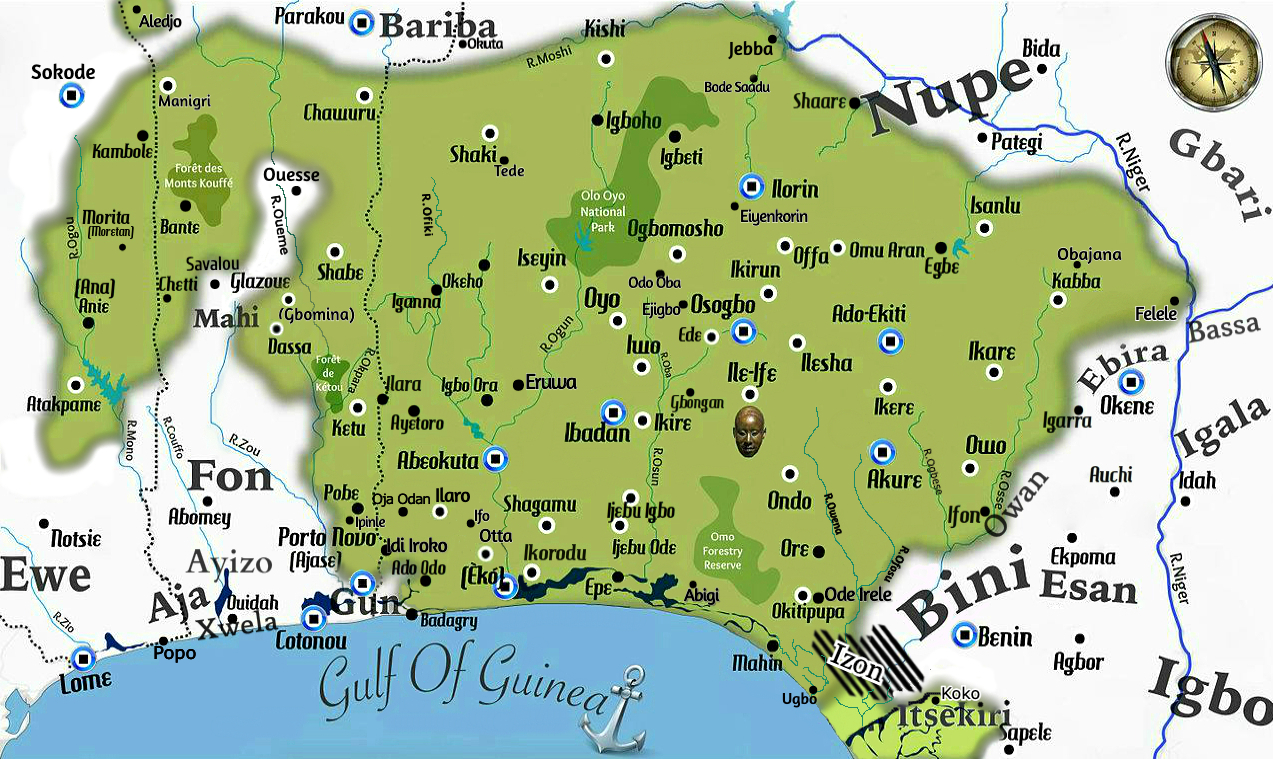
Yorubaland () is the homeland and cultural region of the Yoruba people in West Africa. It spans the modern-day countries of Nigeria, Togo and Benin, and covers a total land area of 142,114 km2 or about 60% of the land area of Ghana. Of this land area, 106,016 km2 (74.6%) lies within Nigeria, 18.9% in Benin, and the remaining 6.5% is in Togo. Prior to European colonization of the Americas, European colonization, a portion of this area was known as Yoruba country. The geo-cultural space contains an estimated 55 million people, the majority of this population being ethnic Yoruba people, Yorubas. Geography Geo-physically, Yorubaland spreads north from the Gulf of Guinea and west from the Niger River into Benin and Togo. In the northern section, Yorubaland begins in the suburbs just west of Lokoja and continues unbroken up to the Ogooué River tributary of the Mono River in Togo, a distance of around 610 km. In the south, it begins in an area just west of the Benin and ... [...More Info...] [...Related Items...] OR: [Wikipedia] [Google] [Baidu] |
List Of Rulers Of Ife
The Ooni of Ile-Ife (Ọọ̀ni of Ilè-Ifẹ̀) is the traditional ruler of Ile-Ife and the spiritual head of the Yoruba people. The Ooni dynasty existed before the reign of Oduduwa which historians have argued to have been between the 7th-9th centuries A.D. After the demise of Oduduwa and Ogun’s loss of the throne, Oduduwa's support base dispersed out of Ile-Ife. Another account but not in tandem with existing evidences states that Ogun purposely sent all Oduduwa's children on different journeys to effect Yoruba territory expansion. Whatever the case, after Oduduwa’s short reign, Obatala re-emerged as the king of Ile-Ife and the throne was rotated between Obatala and Obalufon houses until the return of Oranmiyan who briefly interrupted the succession pattern. Popular history as associated Ooni Lajamisan with Oranmiyan as his son. However, Ife tradition shows that Lajamisan was indeed a descent of Oranfe lineage. Nevertheless, Lajamisan is often said to have opened ... [...More Info...] [...Related Items...] OR: [Wikipedia] [Google] [Baidu] |
Igodomigodo
Igodomigodo is the original name of the Benin Empire used by its own inhabitants (nowadays known as the Edo people of Nigeria). According to Edo oral history, Igodomigodo was the name given to the kingdom by Igodo, the first ''ogiso'' (King), who founded the first dynasty of what would later be known as the Benin Empire (which existed from around 1180 until 1897 in the area of the present-day Federal Republic of Nigeria (and not in the area of the unrelated, current Republic of Benin)). The ''ogiso'' era was replaced by the ''oba'' era, and the name of the kingdom was changed from Igodomigodo to Edo by Oba Eweka I). Replacing the era of the ''ogiso'', the ''oba'' dynasty was founded by Eweka I, the first Oba (and child of Oranmiyan). Eweka I renamed his empire Edo, and since then its people have been called Edo people (or ''ovbi-ẹdo'', "child enof Edo"). The current Oba, Ewuare II, is the 40th Oba and 89th ruler of the dynasty started by Igodo of Igodomigodo. See also * L ... [...More Info...] [...Related Items...] OR: [Wikipedia] [Google] [Baidu] |
Ogiso
This is a list of the independent Ogisos (Kings) of Igodomigodo, which was to become the Benin Empire, from 40 BCE to 1100 CE. The dating is based on the recollection made by Daryl Peavy of the oral traditions of the Edo people. The Ogiso were assisted by seven nobles called the "Uzama". During the reign of ogisos, Edo lands were called Igodomigodo and they had administrative centers or capitals at Ubinu which was later called Benin City. Community autonomy was given to each community by the Ogiso during their reign. References {{reflist External links edo-nation.net Edo people History of Nigeria Ogiso Ogiso This is a list of the independent Ogisos (King King is the title given to a male monarch in a variety of contexts. The female equivalent is queen, which title is also given to the consort of a king. *In the context of prehistory, anti ... Kingdom of Benin ... [...More Info...] [...Related Items...] OR: [Wikipedia] [Google] [Baidu] |

%2C_scene_at_the_river_front.jpg)


