|
Anadyrsk
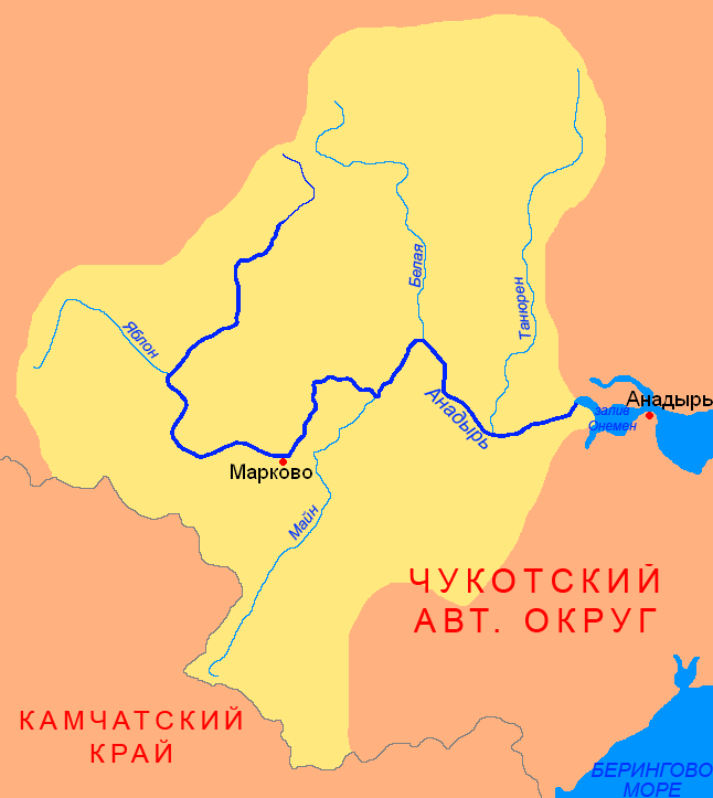
Anadyrsk was an important Russian ostrog (fortified settlement) in far northeastern Siberia from 1649 to 1764. It was on the Anadyr River, near the head of small-boat navigation, about 300 miles upstream, 12 miles northeast of the present Markovo. In 1649 Semyon Dezhnyov built a ''zimov'ye'' (winter quarters) here after being wrecked on the Pacific coast the previous year. In 1650 Mikhail Stadukhin and Semyon Motora arrived overland from the Kolyma River. In 1659 Kurbat Ivanov took over, built a proper stockade and made major improvements in administration. About 1697, Anadyrsk was the launching place for Vladimir Atlasov's conquest of Kamchatka. The local Chukchis and Koryaks were warlike, and the post was attacked a number of times. George Kennan reported that its garrison through much of its service was 600 men and a battery of artillery. Its importance declined with the opening of the sea route through Okhotsk to Kamchatka in 1718. Subsequently, its importance was limited ... [...More Info...] [...Related Items...] OR: [Wikipedia] [Google] [Baidu] |
Markovo, Chukotka Autonomous Okrug
Markovo (russian: Ма́рково; Chukchi: , ''Ujvyn'' / ''Gujgun'', lit. ''wooden hut'';Leontyev and Novikova, p. 329 Koryak: , ''Vujvәn'', lit. ''big village'') is a rural locality (a '' selo'') in Anadyrsky District of Chukotka Autonomous Okrug, Russia, located near the head of small-boat navigation of the Anadyr River. As of the 2010 Census, its population was 809.The results of the 2010 Census and the 2018 estimate are given for Markovo Rural Settlement, a municipal formation of Anadyrsky Municipal District. According to Law #148-OZ, Markovo is the only inhabited locality on the territory of Markovo Rural Settlement. A small locality now—albeit still quite large by Chukotkan standards—Markovo had historically been an important trade hub during the early period of Cossack exploration. Geography Markovo is situated in the middle reaches of the Anadyr River, the largest waterway in Chukotka, in a lowland region with a unique microclimate, surrounded by the ... [...More Info...] [...Related Items...] OR: [Wikipedia] [Google] [Baidu] |
Chukchi People
The Chukchi, or Chukchee ( ckt, Ԓыгъоравэтԓьэт, О'равэтԓьэт, ''Ḷygʺoravètḷʹèt, O'ravètḷʹèt''), are a Siberian indigenous people native to the Chukchi Peninsula, the shores of the Chukchi Sea and the Bering Sea region of the Arctic Ocean all within modern Russia. They speak the Chukchi language. The Chukchi originated from the people living around the Okhotsk Sea. According to several studies on genomic research conduct from 2014 to 2018, the Chukchi are one of the Indigenous peoples of Siberia, they are also the closest Asiatic relatives of the indigenous peoples of the Americas as well as of the Ainu people and other East Asian people, being the descendants of settlers who did not cross the Bering Strait or settled the Japanese archipelago. Cultural history The majority of Chukchi reside within Chukotka Autonomous Okrug, but some also reside in the neighboring Sakha Republic to the west, Magadan Oblast to the southwest, and Kamchatka K ... [...More Info...] [...Related Items...] OR: [Wikipedia] [Google] [Baidu] |
Anadyr River
The Anadyr (russian: Ана́дырь; Yukaghir: Онандырь; ckt, Йъаайваам) is a river in the far northeast of Siberia which flows into the Gulf of Anadyr of the Bering Sea and drains much of the interior of Chukotka Autonomous Okrug. Its basin corresponds to the Anadyrsky District of Chukotka. Geography The Anadyr is long and has a basin of . It is frozen from October to late May and has a maximum flow in June with the snowmelt. It is navigable in small boats for about to near Markovo. West of Markovo it is in the Anadyr Highlands (moderate mountains and valleys with a few trees) and east of Markovo it moves into the Anadyr Lowlands (very flat treeless tundra with lakes and bogs). The drop from Markovo to the sea is less than . It rises at about 67°N latitude and 171°E longitude in the Anadyr Highlands, near the headwaters of the Maly Anyuy, flows southwest receiving the waters of the rivers Yablon and Yeropol, turns east around the Shchuchy Range an ... [...More Info...] [...Related Items...] OR: [Wikipedia] [Google] [Baidu] |
Semyon Dezhnyov
Semyon Ivanovich Dezhnyov ( rus, Семён Ива́нович Дежнёв, p=sʲɪˈmʲɵn ɪˈvanəvʲɪtɕ dʲɪˈʐnʲɵf; sometimes spelled Dezhnyov; c. 1605 – 1673) was a Russian explorer of Siberia and the first European to sail through the Bering Strait, 80 years before Vitus Bering did. In 1648 he sailed from the Kolyma River on the Arctic Ocean to the Anadyr River on the Pacific. His exploit was forgotten for almost a hundred years and Bering is usually given credit for discovering the strait that bears his name. Biography Dezhnyov was a Pomor Russian, born about 1605, possibly in the town of Veliky Ustyug or the village of Pinega. According to the anthropologist Lydia T. Black, Dezhnyov was recruited for Siberian service in 1630, possibly as a service man or government agent. He served for eight years in Tobolsk and Yeniseisk, and then went to Yakutia in 1639, or possibly earlier. He is said to have been a member of the Cossack detachment under Beketov, who is cred ... [...More Info...] [...Related Items...] OR: [Wikipedia] [Google] [Baidu] |
Vladimir Atlasov
Vladimir Vasilyevich Atlasov or Otlasov ( or Отла́сов; between 1661 and 1664 – 1711) was a Siberian Cossack who was the first Russian to organize systematic exploration of the Kamchatka Peninsula. Atlasov Island, an uninhabited volcanic island off the southern tip of Kamchatka, and the Atlasova volcano are named after him. Biography Atlasov was born in Veliky Ustyug. The first mention of him in the historical records comes from around 1682, when he was collecting Yasak on the Aldan River and one of the Uda (Khabarovsk Krai), Uda rivers. In 1695 the voyevoda of Yakutsk appointed Atlasov Bailiff, prikazshchik of Anadyrsk. The Russians here had heard reports of a 'Kamchatka River' to the south and were already collecting yasak on the headwaters of the rivers that flow south toward Kamchatka. At least one of them had followed the Penzhina river to the Sea of Okhotsk. In 1696 he sent Luka Morozko south to explore. Morozko got as far south as the Tigil (river), Tegil river on ... [...More Info...] [...Related Items...] OR: [Wikipedia] [Google] [Baidu] |
Kamchatka
The Kamchatka Peninsula (russian: полуостров Камчатка, Poluostrov Kamchatka, ) is a peninsula in the Russian Far East, with an area of about . The Pacific Ocean and the Sea of Okhotsk make up the peninsula's eastern and western coastlines, respectively. Immediately offshore along the Pacific coast of the peninsula runs the Kuril–Kamchatka Trench. The Kamchatka Peninsula, the Commander Islands, and the Karaginsky Island, constitute the Kamchatka Krai of the Russian Federation. The vast majority of the 322,079 inhabitants are ethnic Russians, although about 13,000 are Koryaks (2014). More than half of the population lives in Petropavlovsk-Kamchatsky (179,526 in 2010) and nearby Yelizovo (38,980). The Kamchatka peninsula contains the volcanoes of Kamchatka, a UNESCO World Heritage Site. Geography Politically, the peninsula forms part of Kamchatka Krai. The southern tip is called Cape Lopatka. (Lopatka is Russian for spade.) The circular bay to t ... [...More Info...] [...Related Items...] OR: [Wikipedia] [Google] [Baidu] |
Kurbat Ivanov
Kurbat Afanasyevich Ivanov (russian: Курбат Афанасьевич Иванов, (died 1667) was a Cossack explorer of Siberia. He was the first Russian to discover Lake Baikal, and to create the first map of the Russian Far East. He also is credited with creation of the early map of Chukotka and Bering Strait, which was the first to show (very schematically) the yet undiscovered Wrangel Island, both Diomede Islands and Alaska. Kurbat Ivanov was born a Yeniseyan Cossack. In 1642 he made the first map of the Russian Far East, based on the explorations of Ivan Moskvitin. Ivanov came to the Verkholensky ostrog on the Lena River, and taking 74 men with him he sailed south up the river on 21 June 1643, having decided to find if the rumors of large body of water south of the Lena were true. He took with him a Tungus prince Mozheul to assist in finding the way. Through the upper Lena and its tributary the Ilikta they reached Primorsky Ridge, crossed it by foot, and by the ... [...More Info...] [...Related Items...] OR: [Wikipedia] [Google] [Baidu] |
History Of Siberia
The early history of Siberia was greatly influenced by the sophisticated nomadic civilizations of the Scythians ( Pazyryk) on the west of the Ural Mountains and Xiongnu ( Noin-Ula) on the east of the Urals, both flourishing before the Christian era. The steppes of Siberia were occupied by a succession of nomadic peoples, including the Khitan people, various Turkic peoples, and the Mongol Empire. In the Late Middle Ages, Tibetan Buddhism spread into the areas south of Lake Baikal. During the Russian Empire, Siberia was chiefly developed as an agricultural province. The government also used it as a place of exile, sending Avvakum, Dostoevsky, and the Decemberists, among others, to work camps in the region. During the 19th century, the Trans-Siberian Railway was constructed, supporting industrialization. This was also aided by discovery and exploitation of vast reserves of Siberian mineral resources. Prehistory and antiquity According to the field of genetic genealogy, people f ... [...More Info...] [...Related Items...] OR: [Wikipedia] [Google] [Baidu] |
Thule
Thule ( grc-gre, Θούλη, Thoúlē; la, Thūlē) is the most northerly location mentioned in ancient Greek literature, ancient Greek and Latin literature, Roman literature and cartography. Modern interpretations have included Orkney, Shetland, northern Scotland, the island of Saaremaa (Ösel) in Estonia, and the Norwegian island of Smøla (island), Smøla.Andreas Kleineberg, Christian Marx, Eberhard Knobloch und Dieter Lelgemann: ''Germania und die Insel Thule. Die Entschlüsselung von Ptolemaios' "Atlas der Oikumene".'' Wissenschaftliche Buchgesellschaft, Darmstadt 2010. In Classics, classical and medieval literature, ''ultima Thule'' (Latin "farthest Thule") acquired a metaphorical meaning of any distant place located beyond the "borders of the known world". By the Late Middle Ages and early modern period, the Greco-Roman Thule was often identified with the real Iceland or Greenland. Sometimes ''Ultima Thule'' was a Latin name for Greenland, when ''Thule'' was used for ... [...More Info...] [...Related Items...] OR: [Wikipedia] [Google] [Baidu] |
Former Populated Places In Russia
A former is an object, such as a template, gauge or cutting die, which is used to form something such as a boat's hull. Typically, a former gives shape to a structure that may have complex curvature. A former may become an integral part of the finished structure, as in an aircraft fuselage, or it may be removable, being using in the construction process and then discarded or re-used. Aircraft formers Formers are used in the construction of aircraft fuselage, of which a typical fuselage has a series from the nose to the empennage, typically perpendicular to the longitudinal axis of the aircraft. The primary purpose of formers is to establish the shape of the fuselage and reduce the column length of stringers to prevent instability. Formers are typically attached to longerons, which support the skin of the aircraft. The "former-and-longeron" technique (also called stations and stringers) was adopted from boat construction, and was typical of light aircraft built until the ad ... [...More Info...] [...Related Items...] OR: [Wikipedia] [Google] [Baidu] |
Defunct Towns In Russia
{{Disambiguation ...
Defunct (no longer in use or active) may refer to: * ''Defunct'' (video game), 2014 * Zombie process or defunct process, in Unix-like operating systems See also * * :Former entities * End-of-life product * Obsolescence Obsolescence is the state of being which occurs when an object, service, or practice is no longer maintained or required even though it may still be in good working order. It usually happens when something that is more efficient or less risky r ... [...More Info...] [...Related Items...] OR: [Wikipedia] [Google] [Baidu] |


