|
Altsek Nunatak
Altsek Nunatak (Nunatak Altsek \'nu-na-tak al-'tsek\) is a rocky hill projecting from the Murgash Glacier in Dryanovo Heights on Greenwich Island, Antarctica. The peak is named after Khan Altsek, whose Bulgars settled in Italy in the 7th century AD. Location The peak is located at which is 1.96 km northeast of Yovkov Point, 740 m southeast of Lloyd Hill, 970 m east of Kotrag Nunatak, 1.6 km west by north of Tile Ridge and 2.5 km north-northwest of Kaspichan Point. See also * Dryanovo Heights Maps * L.L. Ivanov et al. Antarctica: Livingston Island and Greenwich Island, South Shetland Islands. Scale 1:100000 topographic map. Sofia: Antarctic Place-names Commission of Bulgaria, 2005. * L.L. IvanovAntarctica: Livingston Island and Greenwich, Robert, Snow and Smith Islands Scale 1:120000 topographic map. Troyan: Manfred Wörner Foundation, 2009. ReferencesAltsek Nunatak.SCAR Composite Antarctic Gazetteer Bulgarian Antarctic Gazetteer.Antarctic Place-names Comm ... [...More Info...] [...Related Items...] OR: [Wikipedia] [Google] [Baidu] |
Yovkov Point
Yovkov Point (Yovkov Nos \'yov-kov 'nos\) is a point on the southwest coast of Greenwich Island, Antarctica projecting 150 m southwards into McFarlane Strait, forming the northwest side of the entrance to Kramolin Cove. Formed as a result of Murgash Glacier's retreat in the late 20th and early 21st century. The feature is named after the famous Bulgarian writer Yordan Yovkov (1880–1937). Location The point is located at , which is 3.6 km southeast of Kerseblept Nunatak, 2.2 km south-southwest of Lloyd Hill, 2.95 km southwest of Tile Ridge and 1.98 km west-northwest of Kaspichan Point (Bulgarian topographic survey Tangra 2004/05 The Tangra 2004/05 Expedition was commissioned by the Antarctic Place-names Commission at the Ministry of Foreign Affairs of Bulgaria, managed by the Manfred Wörner Foundation, and supported by the Bulgarian Antarctic Institute, the In ... and mapping in 2005 and 2009). Maps * L.L. Ivanov et al. Antarctica: Livin ... [...More Info...] [...Related Items...] OR: [Wikipedia] [Google] [Baidu] |
Composite Antarctic Gazetteer
The Composite Gazetteer of Antarctica (CGA) of the Scientific Committee on Antarctic Research (SCAR) is the authoritative international gazetteer containing all Antarctic toponyms published in national gazetteers, plus basic information about those names and the relevant geographical features. The Gazetteer includes also parts of the International Hydrographic Organization (IHO) General Bathymetric Chart of the Oceans (GEBCO) gazetteer for under-sea features situated south of 60° south latitude. , the overall content of the CGA amounts to 37,893 geographic names for 19,803 features including some 500 features with two or more entirely different names, contributed by the following sources: {, class="wikitable sortable" ! Country ! Names , - , United States , 13,192 , - , United Kingdom , 5,040 , - , Russia , 4,808 , - , New Zealand , 2,597 , - , Australia , 2,551 , - , Argentina , 2,545 , - , Chile , 1,866 , - , Norway , 1,706 , - , Bulgaria , 1,450 , - , G ... [...More Info...] [...Related Items...] OR: [Wikipedia] [Google] [Baidu] |
Kaspichan Point
Kaspichan Point (Nos Kaspichan \'nos 'ka-spi-chan\) is a point on the southeast side of the entrance to Kramolin Cove on the southwest coast of Greenwich Island, Antarctica. Situated next west of Hebrizelm Hill, 1.4 km northwest of Triangle Point, 2 km south-southwest of Tile Ridge, and 2 km southeast of Yovkov Point. Shape enhanced by recent glacier retreat northwest of the point. Bulgarian topographic survey Tangra 2004/05. Named after the town of Kaspichan in northeastern Bulgaria. See also * Kaspichan Kaspichan ( bg, Каспичан, ) is a town in central northeastern Bulgaria, part of Shumen Province. It is located in the eastern Danubian Plain, some from the major Black Sea port Varna and around from the key Danube ports of Ruse and Sil ... Maps * L.L. Ivanov et al. Antarctica: Livingston Island and Greenwich Island, South Shetland Islands. Scale 1:100000 topographic map. Sofia: Antarctic Place-names Commission of Bulgaria, 2005. * L.L. Ivan ... [...More Info...] [...Related Items...] OR: [Wikipedia] [Google] [Baidu] |
Tile Ridge
Tile Ridge (''Rid Tile'' ) is a partly ice-free ridge of elevation 240 m in Dryanovo Heights, Greenwich Island in the South Shetland Islands, Antarctica. The ridge is named after the ancient Tile (Tylis), capital town of the Celtic Kingdom in Thrace, 279–213 BC, and ancestor of the present Bulgarian settlement of Tulovo near Stara Zagora City. Location The ridge is located at , which is 2.3 km east-southeast of Lloyd Hill, 2.55 km north of Triangle Point, and 2.37 km west of Malamir Knoll (Bulgarian topographic survey Tangra 2004/05 and mapping in 2009). See also * List of Bulgarian toponyms in Antarctica Maps * L.L. Ivanov et al. Antarctica: Livingston Island and Greenwich Island, South Shetland Islands. Scale 1:100000 topographic map. Sofia: Antarctic Place-names Commission of Bulgaria, 2005. * L.L. IvanovAntarctica: Livingston Island and Greenwich, Robert, Snow and Smith Islands Scale 1:120000 topographic map. Troyan: Manfred Wörner Foundation, 2009. ... [...More Info...] [...Related Items...] OR: [Wikipedia] [Google] [Baidu] |
Kotrag Nunatak
Kotrag Nunatak (Nunatak Kotrag \'nu-na-tak ko-'trag\) is a conspicuous rocky peak of elevation 290 m projecting from Murgash Glacier, Greenwich Island in the South Shetland Islands, Antarctica. It was named after Khan Kotrag, founder of the Kingdom of Volga Bulgaria in the 7th Century AD. Location The peak is located at which is 540 m southwest of Lloyd Hill, 1.47 km east of Telerig Nunatak, and 970 m west of Altsek Nunatak (Bulgarian topographic survey Tangra 2004/05 and mapping in 2009). Maps * L.L. Ivanov et al. Antarctica: Livingston Island and Greenwich Island, South Shetland Islands. Scale 1:100000 topographic map. Sofia: Antarctic Place-names Commission of Bulgaria, 2005. * L.L. IvanovAntarctica: Livingston Island and Greenwich, Robert, Snow and Smith Islands Scale 1:120000 topographic map. Troyan: Manfred Wörner Foundation, 2009. References Kotrag Nunatak.SCAR Composite Antarctic Gazetteer Bulgarian Antarctic Gazetteer.Antarctic Place-names Commission ... [...More Info...] [...Related Items...] OR: [Wikipedia] [Google] [Baidu] |
Lloyd Hill
Lloyd Hill is an ice-covered hill rising to 335 m in the southwest of Dryanovo Heights, Greenwich Island in the South Shetland Islands, Antarctica. The hill surmounts Teteven Glacier to the north and Murgash Glacier to the southeast. The name derives from 'Lloyd's Land', an early name for Greenwich Island. Location The peak is located at which is 2,6 km south by west of Sevtopolis Peak, 4.9 km southeast of Mount Plymouth, 2.38 km west-northwest of Tile Ridge, 2.17 km north-northeast of Yovkov Point and 3.4 km east of Kerseblept Nunatak (British mapping in 1962 and 1968, and Bulgarian in 2005 and 2009. See also * Breznik Heights * Greenwich Island Greenwich Island (variant historical names ''Sartorius Island'', ''Berezina Island'') is an island long and from (average ) wide, lying between Robert Island and Livingston Island in the South Shetland Islands. Surface area . The name Greenwic ... Maps * L.L. Ivanov et al. Antarctica: Livingston ... [...More Info...] [...Related Items...] OR: [Wikipedia] [Google] [Baidu] |
Italy
Italy ( it, Italia ), officially the Italian Republic, ) or the Republic of Italy, is a country in Southern Europe. It is located in the middle of the Mediterranean Sea, and its territory largely coincides with the homonymous geographical region. Italy is also considered part of Western Europe, and shares land borders with France, Switzerland, Austria, Slovenia and the enclaved microstates of Vatican City and San Marino. It has a territorial exclave in Switzerland, Campione. Italy covers an area of , with a population of over 60 million. It is the third-most populous member state of the European Union, the sixth-most populous country in Europe, and the tenth-largest country in the continent by land area. Italy's capital and largest city is Rome. Italy was the native place of many civilizations such as the Italic peoples and the Etruscans, while due to its central geographic location in Southern Europe and the Mediterranean, the country has also historically been home ... [...More Info...] [...Related Items...] OR: [Wikipedia] [Google] [Baidu] |
Bulgars
The Bulgars (also Bulghars, Bulgari, Bolgars, Bolghars, Bolgari, Proto-Bulgarians) were Turkic semi-nomadic warrior tribes that flourished in the Pontic–Caspian steppe and the Volga region during the 7th century. They became known as nomadic equestrians in the Volga-Ural region, but some researchers say that their ethnic roots can be traced to Central Asia. During their westward migration across the Eurasian steppe, the Bulgar tribes absorbed other tribal groups and cultural influences in a process of ethnogenesis, including Iranian, Finnic and Hunnic tribes. Modern genetic research on Central Asian Turkic people and ethnic groups related to the Bulgars points to an affiliation with Western Eurasian populations. The Bulgars spoke a Turkic language, i.e. Bulgar language of Oghuric branch. They preserved the military titles, organization and customs of Eurasian steppes, as well as pagan shamanism and belief in the sky deity Tangra. The Bulgars became semi-sedentary durin ... [...More Info...] [...Related Items...] OR: [Wikipedia] [Google] [Baidu] |
Altsek
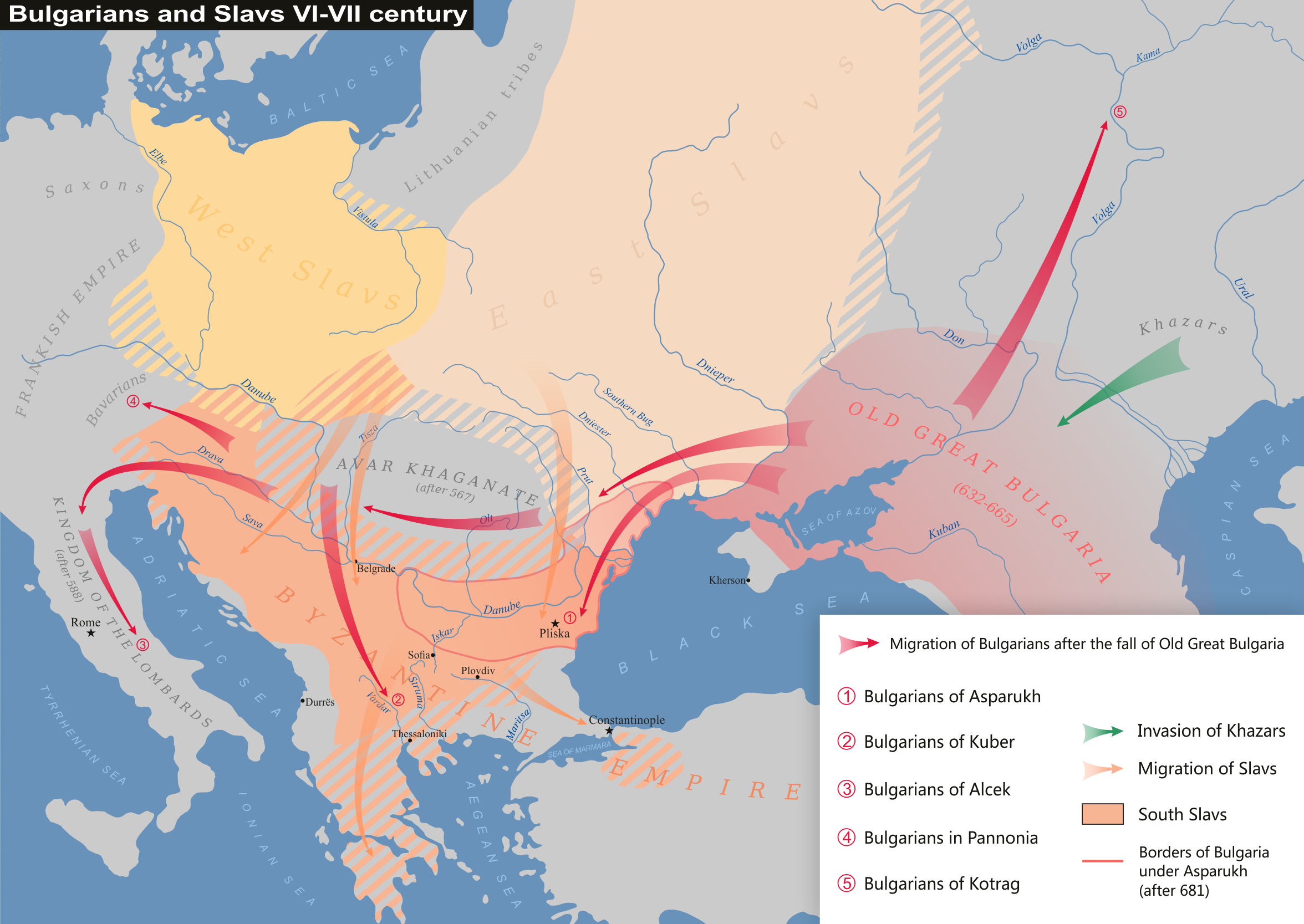
Alcek or Alzeco was allegedly a son of Kubrat and led the Altsikurs to Ravenna that later settled in the villages of Gallo Matese, Sepino, Boiano and Isernia in the Matese mountains of southern Italy. Alzeco should not be confused with the Pannonian Bulgar leader Alciocus who joined the Wends before Alzeco was born. After the collapse of Old Great Bulgaria, some of the Bulgars, led by Alzeco, thought to be a son of Khan Kubrat, settled in the lands of the Longobard Kingdom. Paul the Deacon places a settlement in his history of the migration of the Bulgars in the area of the Duchy of Benevento. Under the leadership of Alzeco, the Bulgars (called "Vulgars" by Paul) came to Italy in Benevento, where they settled in the Molise region. Alciocus The earlier Khagan called Alciocus who was the leader of Bulgar hordes of the Avar Khanganate, is also known. The main source for these events is the medieval chronicle of Fredegar. In 631 Samo led a rebellion against the Pannonian Avars. Al ... [...More Info...] [...Related Items...] OR: [Wikipedia] [Google] [Baidu] |


