|
Ajdabya
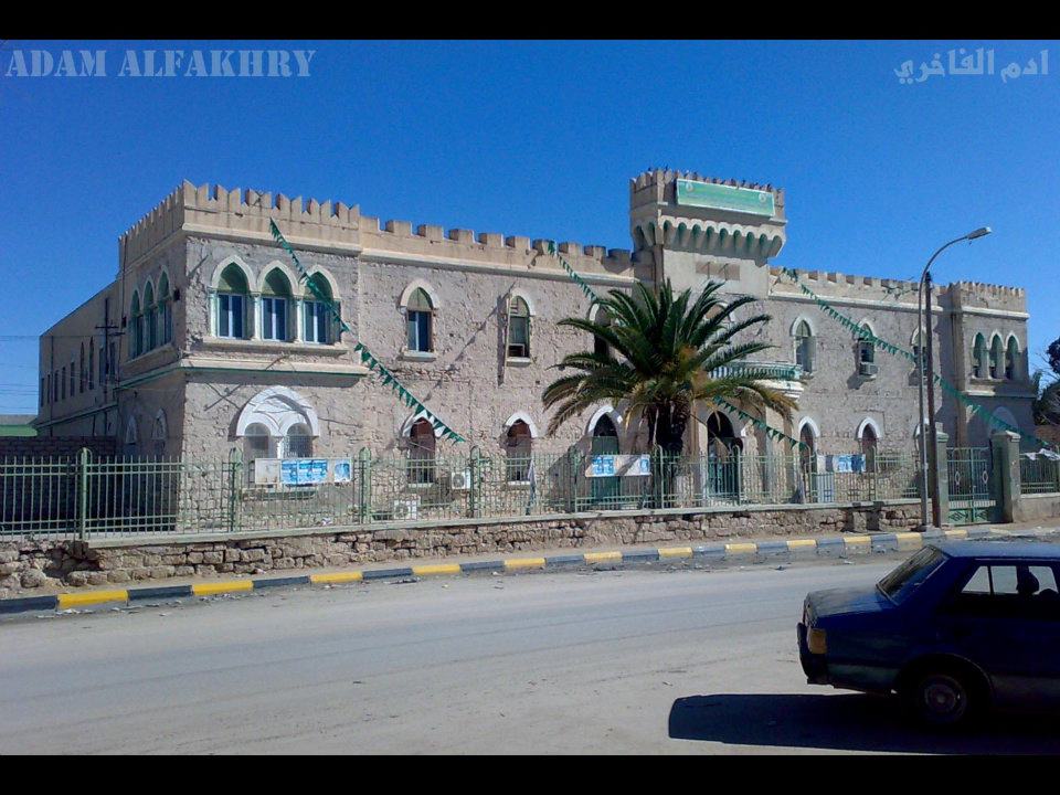
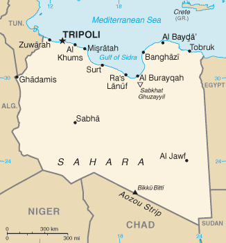
Ajdabiya ( ; ar, أجدابيا, Aǧdābiyā) is a town in and capital of the Al Wahat District in northeastern Libya. It is some south of Benghazi. From 2001 to 2007 it was part of and capital of the Ajdabiya District. The town is divided into three Basic People's Congresses: North Ajdabiya, West Ajdabiya and East Ajdabiya."شعبيات الجماهيرية العظمى " Sha'biyat of Great Jamahiriya, accessed July 6, 2007 During the , the city changed hands several times between rebels and pro-Gaddafi forces, with the anti-Gaddafi forces fi ... [...More Info...] [...Related Items...] OR: [Wikipedia] [Google] [Baidu] |
Benghazi
Benghazi () , ; it, Bengasi; tr, Bingazi; ber, Bernîk, script=Latn; also: ''Bengasi'', ''Benghasi'', ''Banghāzī'', ''Binghāzī'', ''Bengazi''; grc, Βερενίκη (''Berenice'') and ''Hesperides''., group=note (''lit. Son of he Ghazi'') is a city in Libya. Located on the Gulf of Sidra in the Mediterranean, Benghazi is a major seaport and the second-most populous city in the country, as well as the largest city in Cyrenaica, with an estimated population of 807,250 in 2020. A Greek colony named Euesperides had existed in the area from around 525 BC. In the 3rd century BC, it was relocated and refounded as the Ptolemaic city of Berenice. Berenice prospered under the Romans, and after the 3rd century AD it superseded Cyrene and Barca as the centre of Cyrenaica. The city went into decline during the Byzantine period and had already been reduced to a small town before its conquest by the Arabs. In 1911, Italy captured Benghazi and the rest of Tripolitania from the Ott ... [...More Info...] [...Related Items...] OR: [Wikipedia] [Google] [Baidu] |
Cyrenaica
Cyrenaica ( ) or Kyrenaika ( ar, برقة, Barqah, grc-koi, Κυρηναϊκή ��παρχίαKurēnaïkḗ parkhíā}, after the city of Cyrene), is the eastern region of Libya. Cyrenaica includes all of the eastern part of Libya between longitudes E16 and E25, including the Kufra District. The coastal region, also known as '' Pentapolis'' ("Five Cities") in antiquity, was part of the Roman province of Crete and Cyrenaica, later divided into ''Libya Pentapolis'' and ''Libya Sicca''. During the Islamic period, the area came to be known as ''Barqa'', after the city of Barca. Cyrenaica became an Italian colony in 1911. After the 1934 formation of Libya, the Cyrenaica province was designated as one of the three primary provinces of the country. During World War II, it fell under British military and civil administration from 1943 until 1951, and finally in the Kingdom of Libya from 1951 until 1963. The region that used to be Cyrenaica officially until 1963 has formed seve ... [...More Info...] [...Related Items...] OR: [Wikipedia] [Google] [Baidu] |
Gulf Of Sidra
The Gulf of Sidra ( ar, خليج السدرة, Khalij as-Sidra, also known as the Gulf of Sirte ( ar, خليج سرت, Khalij Surt, is a body of water in the Mediterranean Sea on the northern coast of Libya, named after the oil port of Sidra or the city of Sirte. It was also historically known as the Great Sirte or Greater Syrtis ( la, Syrtis Major; grc, Σύρτις μεγάλη; contrasting with Syrtis Minor on the coast of Tunisia). Geography The Gulf of Sidra or Sirte has been a major center for tuna fishing in the Mediterranean for centuries. It gives its name to the city of Sirte situated on its western side. The gulf measures from the promontory of Boreum (now Ras Teyonas) on the East side to the promontory of Cephalae (Ras Kasr Hamet) on the West. The greatest extension of the gulf inland is land inward and occupies an area of 57,000 square kilometres. History Ancient history Syrtis is referred to in the New Testament of the Bible, where Luke relates the Apostl ... [...More Info...] [...Related Items...] OR: [Wikipedia] [Google] [Baidu] |
Byzantine Empire
The Byzantine Empire, also referred to as the Eastern Roman Empire or Byzantium, was the continuation of the Roman Empire primarily in its eastern provinces during Late Antiquity and the Middle Ages, when its capital city was Constantinople. It survived the fragmentation and fall of the Western Roman Empire in the 5th century AD and continued to exist for an additional thousand years until the fall of Constantinople to the Ottoman Empire in 1453. During most of its existence, the empire remained the most powerful economic, cultural, and military force in Europe. The terms "Byzantine Empire" and "Eastern Roman Empire" were coined after the end of the realm; its citizens continued to refer to their empire as the Roman Empire, and to themselves as Romans—a term which Greeks continued to use for themselves into Ottoman times. Although the Roman state continued and its traditions were maintained, modern historians prefer to differentiate the Byzantine Empire from Ancient Rome ... [...More Info...] [...Related Items...] OR: [Wikipedia] [Google] [Baidu] |
Peutinger Table
' (Latin for "The Peutinger Map"), also referred to as Peutinger's Tabula or Peutinger Table, is an illustrated ' (ancient Roman road map) showing the layout of the ''cursus publicus'', the road network of the Roman Empire. The map is a 13th-century parchment copy of a possible Roman original. It covers Europe (without the Iberian Peninsula and the British Isles), North Africa, and parts of Asia, including the Middle East, Persia, and India. According to one hypothesis, the existing map is based on a document of the 4th or 5th century that contained a copy of the world map originally prepared by Agrippa during the reign of the emperor Augustus (27 BC – AD 14). However, Emily Albu has suggested that the existing map could instead be based on an original from the Carolingian period. The map was likely stolen by the renowned humanist Conrad Celtes, who bequeathed it to his friend, the economist and archaeologist Konrad Peutinger, who gave it to Emperor Maximilian I, as part of a ... [...More Info...] [...Related Items...] OR: [Wikipedia] [Google] [Baidu] |
Roman Empire
The Roman Empire ( la, Imperium Romanum ; grc-gre, Βασιλεία τῶν Ῥωμαίων, Basileía tôn Rhōmaíōn) was the post-Republican period of ancient Rome. As a polity, it included large territorial holdings around the Mediterranean Sea in Europe, North Africa, and Western Asia, and was ruled by emperors. From the accession of Caesar Augustus as the first Roman emperor to the military anarchy of the 3rd century, it was a Principate with Italia as the metropole of its provinces and the city of Rome as its sole capital. The Empire was later ruled by multiple emperors who shared control over the Western Roman Empire and the Eastern Roman Empire. The city of Rome remained the nominal capital of both parts until AD 476 when the imperial insignia were sent to Constantinople following the capture of the Western capital of Ravenna by the Germanic barbarians. The adoption of Christianity as the state church of the Roman Empire in AD 380 and the fall of the Western ... [...More Info...] [...Related Items...] OR: [Wikipedia] [Google] [Baidu] |
Deutscher Wetterdienst
The () or DWD for short, is the German Meteorological Service, based in Offenbach am Main, Germany, which monitors weather and meteorological conditions over Germany and provides weather services for the general public and for nautical, aviational, hydrometeorological or agricultural purposes. It is attached to the Federal Ministry for Digital and Transport. The DWDs principal tasks include warning against weather-related dangers and monitoring and rating climate changes affecting Germany. The organisation runs atmospheric models on their supercomputer for precise weather forecasting. The DWD also manages the national climate archive and one of the largest specialised libraries on weather and climate worldwide. History The DWD was formed in 1952 when the weather services of the western occupation zones were merged. In 1954, the Federal Republic of Germany joined the World Meteorological Organization (WMO). In 1990, following the reunification, the weather services of th ... [...More Info...] [...Related Items...] OR: [Wikipedia] [Google] [Baidu] |
Sahara Desert
, photo = Sahara real color.jpg , photo_caption = The Sahara taken by Apollo 17 astronauts, 1972 , map = , map_image = , location = , country = , country1 = , country2 = , country3 = , country4 = , country5 = , country6 = , country7 = , country8 = , country9 = , country10 = ( disputed) , region = , state = , district = , city = , relief = , label = , label_position = , coordinates = , coordinates_ref = , elevation = , elevation_m = , elevation_ft = , elevation_ref = , length = , length_mi = , length_km = 4,800 , length_orientation = , length_note = , width = , width_mi = , widt ... [...More Info...] [...Related Items...] OR: [Wikipedia] [Google] [Baidu] |
Heat Waves
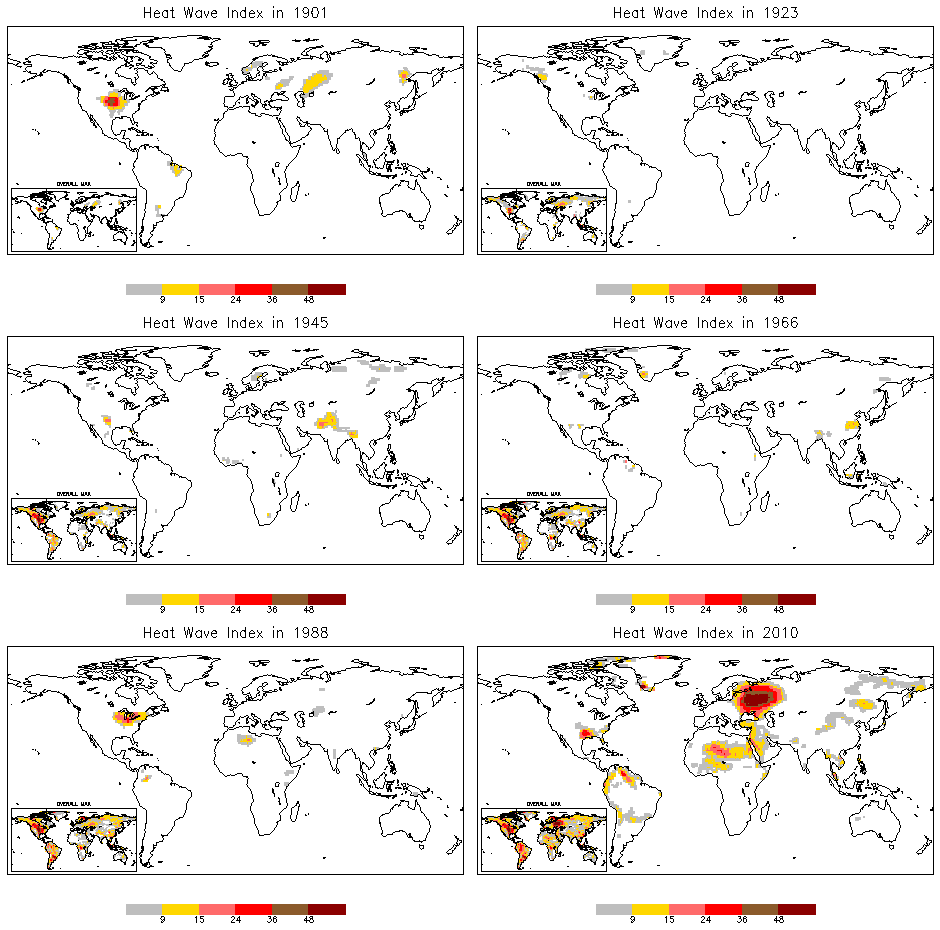
A heat wave, or heatwave, is a period of excessively hot weather, which may be accompanied by high humidity, especially in oceanic climate countries. While definitions vary, a heat wave is usually measured relative to the usual climate in the area and relative to normal temperatures for the season. Temperatures that people from a hotter climate consider normal can be called a heat wave in a cooler area if they are outside the normal climate pattern for that area. The term is applied both to hot weather variations and to extraordinary spells of hot weather which may occur only once a century. Severe heat waves have caused catastrophic crop failures, thousands of deaths from hyperthermia, increased risk of wildfires in areas with drought, and widespread power outages due to increased use of air conditioning. A heat wave is considered extreme weather, and poses danger to human health because heat and sunlight overwhelm the human body's cooling system. Heat waves can usually be ... [...More Info...] [...Related Items...] OR: [Wikipedia] [Google] [Baidu] |
Köppen Climate Classification
The Köppen climate classification is one of the most widely used climate classification systems. It was first published by German-Russian climatologist Wladimir Köppen (1846–1940) in 1884, with several later modifications by Köppen, notably in 1918 and 1936. Later, the climatologist Rudolf Geiger (1894–1981) introduced some changes to the classification system, which is thus sometimes called the Köppen–Geiger climate classification system. The Köppen climate classification divides climates into five main climate groups, with each group being divided based on seasonal precipitation and temperature patterns. The five main groups are ''A'' (tropical), ''B'' (arid), ''C'' (temperate), ''D'' (continental), and ''E'' (polar). Each group and subgroup is represented by a letter. All climates are assigned a main group (the first letter). All climates except for those in the ''E'' group are assigned a seasonal precipitation subgroup (the second letter). For example, ''Af'' indi ... [...More Info...] [...Related Items...] OR: [Wikipedia] [Google] [Baidu] |
Hot Desert Climate
The desert climate or arid climate (in the Köppen climate classification ''BWh'' and ''BWk''), is a dry climate sub-type in which there is a severe excess of evaporation over precipitation. The typically bald, rocky, or sandy surfaces in desert climates are dry and hold little moisture, quickly evaporating the already little rainfall they receive. Covering 14.2% of earth's land area, hot deserts are the second most common type of climate on earth after the polar climate. There are two variations of a desert climate according to the Köppen climate classification: a hot desert climate (''BWh''), and a cold desert climate (''BWk''). To delineate "hot desert climates" from "cold desert climates", there are three widely used isotherms: most commonly a mean annual temperature of , or sometimes the coldest month's mean temperature of , so that a location with a ''BW'' type climate with the appropriate temperature above whichever isotherm is being used is classified as "hot arid sub ... [...More Info...] [...Related Items...] OR: [Wikipedia] [Google] [Baidu] |
Sabkhat Ghuzayyil
Sabkhat Ghuzayyil is Libya's lowest point at 47 meters (154 feet) below sea level, and is just southeast of the Gulf of Sidra. It is located in the Al Wahat District of the Cyrenaica region in northeastern Libya. The area is dry today but in the Holocene Wet Phase it was flooded. Ajdabiya is the main city in the area which is located just northeast of the coastal areas below sea level. Brega Brega , also known as ''Mersa Brega'' or ''Marsa al-Brega'' ( ar, مرسى البريقة , i.e. "Brega Seaport"), is a complex of several smaller towns, industry installations and education establishments situated in Libya on the Gulf of Sidra, ... is a smaller city located more westerly near the shore and is wedged between the sea and these low-lying lands. Geography of Libya Al Wahat District Lowest points {{Libya-geo-stub ... [...More Info...] [...Related Items...] OR: [Wikipedia] [Google] [Baidu] |


