|
Administrative Divisions Of Portugal
Portugal is a unitary state with delegated authority to three levels of local government that cover the entire country: * 2 Autonomous Regions of Portugal, autonomous regions (Azores and Madeira), and in Continental Portugal: 2 Metropolitan areas in Portugal, metropolitan areas, and 21 Intermunicipal communities of Portugal, intermunicipal communities * 308 Municipalities of Portugal, municipalities * 3091 Freguesia, civil parishes () (except Corvo Island which only has a single municipality) The Judiciary of Portugal has a separate geographic system. Portugal has a long history of complex, inconsistent and layered administrative geography. As a result, there is no single, unified layer of administrative units that spans the entire Portugal. The government structure is based on the Constitution of Portugal, 1976 Constitution, adopted after the 1974 Carnation Revolution. - Articles 225-262 The powers of the 18 Districts were removed when the government decided not to reappoint ... [...More Info...] [...Related Items...] OR: [Wikipedia] [Google] [Baidu] |
List Of Cities In Portugal
This is a list of cities in Portugal. In Portugal, a city () is an honorific term given to locations that meet several criteria, such as having a minimum number of inhabitants good infrastructure (schools, medical care, cultural and sports facilities), or have a major historical importance. The country's demographic expansion of the 1980s prompted the elevation of several towns to city status and, as of 2018, 159 locations in Portugal are considered a city. Overview In Portugal, the city is not an administrative division, therefore a city generally does not necessarily correspond to a municipality, which is the second-level local government in the country. Some entirely urban municipalities do coincide with cities, such as Lisbon, Porto, Funchal, Amadora, Entroncamento, and São João da Madeira. The municipality with the most cities is Paredes Municipality, which contains four cities. Until 1910, a location was proclaimed city by royal charter (''carta régia''), which happen ... [...More Info...] [...Related Items...] OR: [Wikipedia] [Google] [Baidu] |
Castelo Branco District
Castelo Branco District ( ) is located in Central Portugal. Its capital is Castelo Branco, which is now also its most populous city, overtaking Covilhã, which was once the largest city, in the late 2010s. It has an area of (4th largest in Portugal), and a population of 225,916 inhabitants. It borders Spain (Extremadura). Municipalities The district is composed of 11 municipalities: * Belmonte * Castelo Branco * Covilhã * Fundão * Idanha-a-Nova * Oleiros * Penamacor * Proença-a-Nova * Sertã Sertã (), officially Sertã Town (), is a municipality in Castelo Branco District in Portugal. The population in 2011 was 15,880, in an area of 446.73 km2. The present mayor is José Farinha Nunes, elected by the PSD. The municipal holida ... * Vila de Rei * Vila Velha de Ródão Summary of votes and seats won in national elections since 1976 , - class="unsortable" !rowspan=2, Parties!!%!!S!!%!!S!!%!!S!!%!!S!!%!!S!!%!!S!!%!!S!!%!!S!!%!!S!!%!!S!!%!!S!!%!!S!!%!!S!!% ... [...More Info...] [...Related Items...] OR: [Wikipedia] [Google] [Baidu] |
Portalegre District
Portalegre District ( ) is located in the east of Portugal. The district capital is the city of Portalegre. As of 2021, it is the least populous district of Portugal. It borders Spain. Municipalities The district is composed of 15 municipalities: * Alter do Chão * Arronches * Avis * Campo Maior * Castelo de Vide * Crato * Elvas * Fronteira * Gavião * Marvão * Monforte * Nisa * Ponte de Sor * Portalegre * Sousel Summary of votes and seats won 1976–2022 , - class="unsortable" !rowspan=2, Parties!!%!!S!!%!!S!!%!!S!!%!!S!!%!!S!!%!!S!!%!!S!!%!!S!!%!!S!!%!!S!!%!!S!!%!!S!!%!!S!!%!!S!!%!!S!!%!!S , - class="unsortable" align="center" !colspan=2 , 1976 !colspan=2 , 1979 !colspan=2 , 1980 !colspan=2 , 1983 !colspan=2 , 1985 !colspan=2 , 1987 !colspan=2 , 1991 !colspan=2 , 1995 !colspan=2 , 1999 !colspan=2 , 2002 !colspan=2 , 2005 !colspan=2 , 2009 !colspan=2 , 2011 !colspan=2 , 2015 !colspan=2 , 2019 !colspan=2 , 2022 , - , align="left", PS , , ... [...More Info...] [...Related Items...] OR: [Wikipedia] [Google] [Baidu] |
Évora District
Évora District ( ) is located in Alentejo, in southern Portugal. The district capital is the city of Évora. It borders Spain. Municipalities The district is composed by 14 municipalities: * Alandroal * Arraiolos * Borba * Estremoz * Évora * Montemor-o-Novo * Mora * Mourão * Portel * Redondo * Reguengos de Monsaraz * Vendas Novas * Viana do Alentejo * Vila Viçosa All 14 municipalities is divided into 69 parishes or freguesias. Summary of votes and seats won 1976–2022 , - class="unsortable" !rowspan=2, Parties!!%!!S!!%!!S!!%!!S!!%!!S!!%!!S!!%!!S!!%!!S!!%!!S!!%!!S!!%!!S!!%!!S!!%!!S!!%!!S!!%!!S!!%!!S!!%!!S , - class="unsortable" align="center" !colspan=2 , 1976 !colspan=2 , 1979 !colspan=2 , 1980 !colspan=2 , 1983 !colspan=2 , 1985 !colspan=2 , 1987 !colspan=2 , 1991 !colspan=2 , 1995 !colspan=2 , 1999 !colspan=2 , 2002 !colspan=2 , 2005 !colspan=2 , 2009 !colspan=2 , 2011 !colspan=2 , 2015 !colspan=2 , 2019 !colspan=2 , 2022 , - , align="left ... [...More Info...] [...Related Items...] OR: [Wikipedia] [Google] [Baidu] |
Faro District
Faro District ( ) is the southernmost district of Portugal. The area is the same as that of the Algarve region. The administrative centre, or district capital, is the city of Faro. It borders Spain. Municipalities The district is composed of 16 municipalities: * Albufeira * Alcoutim * Aljezur * Castro Marim * Faro * Lagoa * Lagos * Loulé * Monchique * Olhão * Portimão * São Brás de Alportel * Silves * Tavira * Vila do Bispo * Vila Real de Santo António All 16 municipalities are divided into 67 parishes or freguesias. Cities * Albufeira * Faro * Lagoa * Lagos * Loulé * Olhão * Portimão * Quarteira (Loulé) * Silves * Tavira * Vila Real de Santo António Villages * Alcantarilha (Silves) * Alcoutim * Algoz (Silves) * Almancil (Loulé) * Alvor (Portimão) * Armação de Pêra (Silves) * Aljezur * Bensafrim (Lagos) * Cabanas de Tavira (Tavira) * Carvoeiro (Lagoa) * Castro Marim * Estômbar (Lagoa) * Ferragudo (Lagoa) * Fuseta (Olhã ... [...More Info...] [...Related Items...] OR: [Wikipedia] [Google] [Baidu] |
Beja District
The Beja District (; ) is located in southern Portugal. The district capital is the city of Beja. It is the largest district of the country by area, comprising around 11% of Portuguese territory. It borders Spain. Municipalities The district is composed of 14 municipalities: * Aljustrel * Almodôvar * Alvito * Barrancos * Beja * Castro Verde * Cuba * Ferreira do Alentejo * Mértola * Moura * Odemira * Ourique * Serpa * Vidigueira All 14 municipalities are divided into 75 freguesias or parishes. Summary of votes and seats won 1976-2022 , - class="unsortable" !rowspan=2, Parties!!%!!S!!%!!S!!%!!S!!%!!S!!%!!S!!%!!S!!%!!S!!%!!S!!%!!S!!%!!S!!%!!S!!%!!S!!%!!S!!%!!S!!%!!S!!%!!S , - class="unsortable" align="center" !colspan=2 , 1976 !colspan=2 , 1979 !colspan=2 , 1980 !colspan=2 , 1983 !colspan=2 , 1985 !colspan=2 , 1987 !colspan=2 , 1991 !colspan=2 , 1995 !colspan=2 , 1999 !colspan=2 , 2002 !colspan=2 , 2005 !colspan=2 , 2009 !colspan=2 , 2011 !colspan=2 ... [...More Info...] [...Related Items...] OR: [Wikipedia] [Google] [Baidu] |
Setúbal District
The District of Setúbal ( ) is a district located in the south-west of Portugal. It is named for its capital, the city of Setúbal. Geography It is delimited by Lisbon District and Santarém District on the north, Évora District on the east, Beja District on the south and the Atlantic Ocean on the west. It has a population of 887,928 inhabitants, in an area of . The district was carved out of Lisbon District in 1926, and is the only Portuguese district created after 1835. Municipalities It is composed of 13 municipalities, spread over two sub regions and comprising 55 parishes: * Península de Setúbal Subregion NUTS II Sub-Region: ** Alcochete ** Almada ** Barreiro ** Moita ** Montijo ** Palmela ** Seixal ** Sesimbra ** Setúbal * Alentejo Litoral Subregion: ** Alcácer do Sal ** Grândola ** Santiago do Cacém ** Sines List of Parliamentary Representatives Summary of votes and seats won 1976-2022 , - class="unsortable" !rowspan=2, Parties!!%!!S! ... [...More Info...] [...Related Items...] OR: [Wikipedia] [Google] [Baidu] |
Santarém District
The District of Santarém ( ) is a district of Portugal, located in Portugal's West and Tagus Valley region. The district capital is the city of Santarém. The district is the 3rd largest in Portugal, with an area of , and a population of 475,344 inhabitants, giving it a population density of 70 people per sq. kilometer (180 people per sq. mile). Municipalities The district includes the following 21 municipalities. * Abrantes * Alcanena * Almeirim * Alpiarça * Benavente * Cartaxo * Chamusca * Constância * Coruche * Entroncamento * Ferreira do Zêzere * Golegã * Mação * Ourém * Rio Maior * Salvaterra de Magos * Santarém * Sardoal * Tomar * Torres Novas * Vila Nova da Barquinha Summary of votes and seats won 1976–2022 , - class="unsortable" !rowspan=2, Parties!!%!!S!!%!!S!!%!!S!!%!!S!!%!!S!!%!!S!!%!!S!!%!!S!!%!!S!!%!!S!!%!!S!!%!!S!!%!!S!!%!!S!!%!!S!!%!!S , - class="unsortable" align="center" !colspan=2 , 1976 !colspan=2 , 1979 !colspan=2 , 1980 !co ... [...More Info...] [...Related Items...] OR: [Wikipedia] [Google] [Baidu] |
Leiria District
The District of Leiria ( ) is a district located between the Oeste e Vale do Tejo and Centro regions of Portugal, and divided between the traditional provinces of Beira Litoral and Estremadura. It borders on the north with district of Coimbra, on the east with district of Castelo Branco and with district of Santarém, on the south with district of Lisbon and on the west with the Atlantic Ocean. The district capital is the city of Leiria. Municipalities In the current main division of the country, the district is divided into two NUTS of Portugal, the Oeste e Vale do Tejo and the Centro regions, with its municipalities distributed by the Nomenclatures of territorial units for statistical purposes (NUTIII) of the Oeste (which was integrated into the new NUTII created in 2023) and the Leiria region. * Oeste e Vale do Tejo ** Oeste *** Alcobaça *** Bombarral *** Caldas da Rainha *** Nazaré *** Óbidos *** Peniche * Centro ** Leiria region *** Alvaiázere *** ... [...More Info...] [...Related Items...] OR: [Wikipedia] [Google] [Baidu] |
Lisbon District
Lisbon District () is a district located along the western coast of Portugal. The district capital is the city of Lisbon, which is also the national capital. From its creation until 1926, it included the area of the current Setúbal District. Municipalities The district is composed of 16 municipalities: * Alenquer * Amadora * Arruda dos Vinhos * Azambuja * Cadaval * Cascais * Lisbon * Loures * Lourinhã * Mafra * Odivelas * Oeiras * Sintra * Sobral de Monte Agraço * Torres Vedras * Vila Franca de Xira Summary of votes and seats won (1976–2022) , - class="unsortable" !rowspan=2, Parties!!%!!S!!%!!S!!%!!S!!%!!S!!%!!S!!%!!S!!%!!S!!%!!S!!%!!S!!%!!S!!%!!S!!%!!S!!%!!S!!%!!S!!%!!S!!%!!S , - class="unsortable" align="center" !colspan=2 , 1976 !colspan=2 , 1979 !colspan=2 , 1980 !colspan=2 , 1983 !colspan=2 , 1985 !colspan=2 , 1987 !colspan=2 , 1991 !colspan=2 , 1995 !colspan=2 , 1999 !colspan=2 , 2002 !colspan=2 , 2005 !colspan=2 , 2009 !colspan=2 , 2 ... [...More Info...] [...Related Items...] OR: [Wikipedia] [Google] [Baidu] |
Continental Portugal
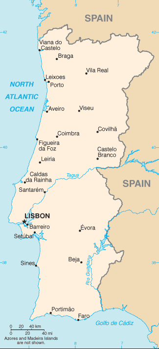
Continental Portugal (, ) or mainland Portugal comprises the bulk of the Portuguese Republic, namely that part on the Iberian Peninsula and so in continental Europe, having approximately 95% of the total population and 96.6% of the country's land. Mainland Portugal is therefore commonly called by residents of the Portuguese archipelagos of the Azores and Madeira the continent () in all respects including minor elements of combined governance from Lisbon, the country's capital. Before 1975, when the Portuguese territory also stretched to several now-independent states in Africa, the designation ''metropolis'' () was also used. Context The designation ''mainland Portugal'' is used to differentiate the continental territory of Portugal from its insular territory. The latter comprises the archipelagos of Madeira and Azores in the Atlantic Ocean. The Azores and Madeira are also commonly referred to as the autonomous regions (), insular Portugal () or, simply, the islands (). Co ... [...More Info...] [...Related Items...] OR: [Wikipedia] [Google] [Baidu] |


