|
A3(M) Motorway
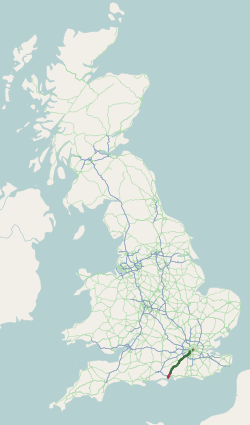
The A3, known as the Portsmouth Road or London Road in sections, is a major road connecting the City of London and Portsmouth passing close to Kingston upon Thames, Guildford, Haslemere and Petersfield. For much of its length, it is classified as a trunk road and therefore managed by National Highways. Almost all of the road has been built to dual carriageway standards or wider. Apart from bypass sections in London, the road travels in a southwest direction and, after Liss, south-southwest. Close to its southerly end, motorway traffic is routed via the A3(M), then either the east–west A27 or the Portsmouth-only M275 which has multiple lanes leading off the westbound A27 — for non-motorway traffic, the A3 continues into Portsmouth alongside the A3(M), mostly as a single carriageway in each direction through Waterlooville and adjoining small towns. The other section of single carriageways is through the urban environs of Battersea, Clapham and Stockwell towards ... [...More Info...] [...Related Items...] OR: [Wikipedia] [Google] [Baidu] |
A3 Road Map
A3, A03 or A.III may refer to: * A3 paper, a paper size defined by ISO 216 Biology * A3 regulatory sequence, a sequence for the insulin gene * Adenosine A3 receptor, a human gene * Annexin A3, a human gene * ATC code A03 ''Drugs for functional gastrointestinal disorders'', a subgroup of the Anatomical Therapeutic Chemical Classification System * Brachydactyly type A3, a disease * British NVC community A3 (Spirodela polyrhiza - Hydrocharis morsus-ranae community), a British Isles plants community * Gibberellin A3, a plant hormone * HLA-A3, a Human MHC Serotype HLA-A * Subfamily A3, a rhodopsin-like receptors subfamily * Urea transporter A3, a trans-membrane protein Games * '' A3!'', a Japanese video game and multimedia franchise * A3 - Assault on the Aerie of the Slave Lords, a 1981 module for the Dungeons & Dragons fantasy role-playing game * Alpha Trion, as the former name of this character from the Transformers Series * Bird's Opening (A03), in chess, by the Encyclopae ... [...More Info...] [...Related Items...] OR: [Wikipedia] [Google] [Baidu] |
Waterlooville
Waterlooville is a market town in the Borough of Havant in Hampshire, England, approximately north northeast of Portsmouth. It is the largest town in the borough. The town has a population of about 64,350 and is surrounded by Purbrook, Blendworth, Cowplain, Lovedean, Clanfield, Catherington, Crookhorn, Denmead, Hambledon, Horndean and Widley. It forms part of the South Hampshire conurbation. The town formed around the old A3 London to Portsmouth road. Waterlooville is twinned with Maurepas, Yvelines in France and Henstedt-Ulzburg in Germany. History It is reputed that the name derived from a pub that stood at the centre of the town, then known as Wait Lane End, where the stage-coach horses waited to change places with the team that pulled the coach up and over Portsdown Hill. The pub had been named ''Heroes of Waterloo'' because, on its opening day. in 1815, soldiers who had just disembarked at Portsmouth, returning from the Battle of Waterloo, decided to stop there and c ... [...More Info...] [...Related Items...] OR: [Wikipedia] [Google] [Baidu] |
Motorway
A controlled-access highway is a type of highway that has been designed for high-speed vehicular traffic, with all traffic flow—ingress and egress—regulated. Common English terms are freeway, motorway and expressway. Other similar terms include '' throughway'' and '' parkway''. Some of these may be limited-access highways, although this term can also refer to a class of highways with somewhat less isolation from other traffic. In countries following the Vienna convention, the motorway qualification implies that walking and parking are forbidden. A fully controlled-access highway provides an unhindered flow of traffic, with no traffic signals, intersections or property access. They are free of any at-grade crossings with other roads, railways, or pedestrian paths, which are instead carried by overpasses and underpasses. Entrances and exits to the highway are provided at interchanges by slip roads (ramps), which allow for speed changes between the highway and arteri ... [...More Info...] [...Related Items...] OR: [Wikipedia] [Google] [Baidu] |
South Downs
The South Downs are a range of chalk hills that extends for about across the south-eastern coastal counties of England from the Itchen valley of Hampshire in the west to Beachy Head, in the Eastbourne Downland Estate, East Sussex, in the east. The Downs are bounded on the northern side by a steep escarpment, from whose crest there are extensive views northwards across the Weald. The South Downs National Park forms a much larger area than the chalk range of the South Downs and includes large parts of the Weald. The South Downs are characterised by rolling chalk downland with close-cropped turf and dry valleys, and are recognised as one of the most important chalk landscapes in England. The range is one of the four main areas of chalk downland in southern England. The South Downs are relatively less populated compared to South East England as a whole, although there has been large-scale urban encroachment onto the chalk downland by major seaside resorts, including most notably ... [...More Info...] [...Related Items...] OR: [Wikipedia] [Google] [Baidu] |
Esher
Esher ( ) is a town in Surrey, England, to the east of the River Mole. Esher is an outlying suburb of London near the London-Surrey Border, and with Esher Commons at its southern end, the town marks one limit of the Greater London Built-Up Area. Esher has a linear commercial high street and is otherwise suburban in density, with varying elevations, few high rise buildings and very short sections of dual carriageway within the ward itself. Esher covers a large area, between 13 and 15.4 miles southwest of Charing Cross. In the south it is bounded by the A3 Portsmouth Road which is of urban motorway standard and buffered by the Esher Commons. Esher is bisected by the A307, historically the Portsmouth Road, which for approximately forms its high street. Esher railway station (served by the South West Main Line) connects the town to London Waterloo. Sandown Park Racecourse is in the town near the station. In the south, Claremont Landscape Garden owned and managed by the National ... [...More Info...] [...Related Items...] OR: [Wikipedia] [Google] [Baidu] |
Kingston-upon-Thames
Kingston upon Thames (hyphenated until 1965, colloquially known as Kingston) is a town in the Royal Borough of Kingston upon Thames, southwest London, England. It is situated on the River Thames and southwest of Charing Cross. It is notable as the ancient market town in which Saxon kings were crowned and today is the administrative centre of the Royal Borough. Historically in the county of Surrey, the ancient parish of Kingston became absorbed in the Municipal Borough of Kingston-upon-Thames, reformed in 1835. From 1893 to 2021 it was the location of Surrey County Council, extraterritorially in terms of local government administration since 1965, when Kingston became a part of Greater London. Today, most of the town centre is part of the KT1 postcode area, but some areas north of Kingston railway station are within KT2. The United Kingdom Census 2011 recorded the population of the town (comprising the four wards of Canbury, Grove, Norbiton and Tudor) as 43,013, while the ... [...More Info...] [...Related Items...] OR: [Wikipedia] [Google] [Baidu] |
A307 Road
The A307 road runs through SW London and NW Surrey. It is primary at the north-east end; the remainder is non-primary, generally superseded in the mid-twentieth century in two stages by newer alignments of the Portsmouth Road, the Kingston bypass and Esher bypass of the A3, which runs along a slightly oblique axis. Route London Borough of Richmond upon Thames: Kew and Richmond The road begins at the junction with the A205 South Circular Road beside Kew Green , where it is named Kew Road. It then runs towards Richmond upon Thames through the west of Kew. At the junction with the A316 in Richmond it becomes a non-primary A-road through the town centre then heads through Petersham where for fewer than 100 metres it kinks west and then travels south through Ham. A B-class road, the B353, leaves the A307 in Kew and runs around the town centre and up Richmond Hill and by-passing Richmond, before rejoining the A307 at Petersham. Royal Borough of Kingston upon Thames: Kingston up ... [...More Info...] [...Related Items...] OR: [Wikipedia] [Google] [Baidu] |
Bypass (road)
A bypass is a road or highway that avoids or "bypasses" a built-up area, town, or village, to let through traffic flow without interference from local traffic, to reduce congestion in the built-up area, and to improve road safety. A bypass specifically designated for trucks may be called a truck route. If there are no strong land use controls, buildings are often built in town along a bypass, converting it into an ordinary town road, and the bypass may eventually become as congested as the local streets it was intended to avoid. Petrol station A filling station, also known as a gas station () or petrol station (), is a facility that sells fuel and engine lubricants for motor vehicles. The most common fuels sold in the 2010s were gasoline (or petrol) and diesel fuel. Gaso ...s, shopping centres and some other businesses are often built there for ease of access, while homes are often avoided for noise and pollution reasons. Bypass routes are often controversial, ... [...More Info...] [...Related Items...] OR: [Wikipedia] [Google] [Baidu] |
Godalming
Godalming is a market town and civil parish in southwest Surrey, England, around southwest of central London. It is in the Borough of Waverley, at the confluence of the Rivers Wey and Ock. The civil parish covers and includes the settlements of Farncombe, Binscombe and Holloway Hill. Much of the area lies on the strata of the Lower Greensand Group and Bargate stone was quarried locally until the Second World War. The earliest evidence of human activity is from the Paleolithic and the River Wey floodplain at Charterhouse was settled in the middle Iron Age and Roman period. The modern town is thought to have its origins in the 6th or early 7th centuries and its name is thought to derive from that of a Saxon landowner. Kersey, a woollen cloth, dyed blue, was produced at Godalming for much of the Middle Ages, but the industry declined in the early modern period. In the 17th century, the town began to specialise in the production of knitted textiles and in the manufactur ... [...More Info...] [...Related Items...] OR: [Wikipedia] [Google] [Baidu] |
Chichester
Chichester () is a cathedral city and civil parish in West Sussex, England.OS Explorer map 120: Chichester, South Harting and Selsey Scale: 1:25 000. Publisher:Ordnance Survey – Southampton B2 edition. Publishing Date:2009. It is the only city in West Sussex and is its county town. It was a Roman and Anglo-Saxon settlement and a major market town from those times through Norman and medieval times to the present day. It is the seat of the Church of England Diocese of Chichester, with a 12th-century cathedral. The city has two main watercourses: the Chichester Canal and the River Lavant. The Lavant, a winterbourne, runs to the south of the city walls; it is hidden mostly in culverts when close to the city centre. History Roman period There is no recorded evidence that the city that became Chichester was a settlement of any size before the coming of the Romans. The area around Chichester is believed to have played a significant part during the Roman invasion of AD 43, ... [...More Info...] [...Related Items...] OR: [Wikipedia] [Google] [Baidu] |
Royal Navy
The Royal Navy (RN) is the United Kingdom's naval warfare force. Although warships were used by English and Scottish kings from the early medieval period, the first major maritime engagements were fought in the Hundred Years' War against France. The modern Royal Navy traces its origins to the early 16th century; the oldest of the UK's armed services, it is consequently known as the Senior Service. From the middle decades of the 17th century, and through the 18th century, the Royal Navy vied with the Dutch Navy and later with the French Navy for maritime supremacy. From the mid 18th century, it was the world's most powerful navy until the Second World War. The Royal Navy played a key part in establishing and defending the British Empire, and four Imperial fortress colonies and a string of imperial bases and coaling stations secured the Royal Navy's ability to assert naval superiority globally. Owing to this historical prominence, it is common, even among non-Britons, to ref ... [...More Info...] [...Related Items...] OR: [Wikipedia] [Google] [Baidu] |
A3 North - Approaching The Wisley Interchange
A3, A03 or A.III may refer to: * A3 paper, a paper size defined by ISO 216 Biology * A3 regulatory sequence, a sequence for the insulin gene * Adenosine A3 receptor, a human gene * Annexin A3, a human gene * ATC code A03 ''Drugs for functional gastrointestinal disorders'', a subgroup of the Anatomical Therapeutic Chemical Classification System * Brachydactyly type A3, a disease * British NVC community A3 (Spirodela polyrhiza - Hydrocharis morsus-ranae community), a British Isles plants community * Gibberellin A3, a plant hormone * HLA-A3, a Human MHC Serotype HLA-A * Subfamily A3, a rhodopsin-like receptors subfamily * Urea transporter A3, a trans-membrane protein Games * '' A3!'', a Japanese video game and multimedia franchise * A3 - Assault on the Aerie of the Slave Lords, a 1981 module for the Dungeons & Dragons fantasy role-playing game * Alpha Trion, as the former name of this character from the Transformers Series * Bird's Opening (A03), in chess, by the Encyclopaedia o ... [...More Info...] [...Related Items...] OR: [Wikipedia] [Google] [Baidu] |


