|
3d Scanner
3D scanning is the process of analyzing a real-world object or environment to collect three dimensional data of its shape and possibly its appearance (e.g. color). The collected data can then be used to construct digital 3D models. A 3D scanner can be based on many different technologies, each with its own limitations, advantages and costs. Many limitations in the kind of objects that can be digitized are still present. For example, optical technology may encounter difficulties with dark, shiny, reflective or transparent objects while industrial computed tomography scanning, structured-light 3D scanners, LiDAR and Time Of Flight 3D Scanners can be used to construct digital 3D models, without destructive testing. Collected 3D data is useful for a wide variety of applications. These devices are used extensively by the entertainment industry in the production of movies and video games, including virtual reality. Other common applications of this technology include augmented rea ... [...More Info...] [...Related Items...] OR: [Wikipedia] [Google] [Baidu] |
Reverse Engineering
Reverse engineering (also known as backwards engineering or back engineering) is a process or method through which one attempts to understand through deductive reasoning how a previously made device, process, system, or piece of software accomplishes a task with very little (if any) insight into exactly how it does so. Depending on the system under consideration and the technologies employed, the knowledge gained during reverse engineering can help with repurposing obsolete objects, doing security analysis, or learning how something works. Although the process is specific to the object on which it is being performed, all reverse engineering processes consist of three basic steps: information extraction, modeling, and review. Information extraction is the practice of gathering all relevant information for performing the operation. Modeling is the practice of combining the gathered information into an abstract model, which can be used as a guide for designing the new object or syst ... [...More Info...] [...Related Items...] OR: [Wikipedia] [Google] [Baidu] |
X-ray
An X-ray (also known in many languages as Röntgen radiation) is a form of high-energy electromagnetic radiation with a wavelength shorter than those of ultraviolet rays and longer than those of gamma rays. Roughly, X-rays have a wavelength ranging from 10 Nanometre, nanometers to 10 Picometre, picometers, corresponding to frequency, frequencies in the range of 30 Hertz, petahertz to 30 Hertz, exahertz ( to ) and photon energies in the range of 100 electronvolt, eV to 100 keV, respectively. X-rays were discovered in 1895 in science, 1895 by the German scientist Wilhelm Röntgen, Wilhelm Conrad Röntgen, who named it ''X-radiation'' to signify an unknown type of radiation.Novelline, Robert (1997). ''Squire's Fundamentals of Radiology''. Harvard University Press. 5th edition. . X-rays can penetrate many solid substances such as construction materials and living tissue, so X-ray radiography is widely used in medical diagnostics (e.g., checking for Bo ... [...More Info...] [...Related Items...] OR: [Wikipedia] [Google] [Baidu] |
Coordinate-measuring Machine
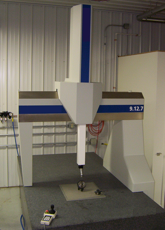
A coordinate-measuring machine (CMM) is a device that measures the geometry of physical objects by sensing discrete points on the surface of the object with a probe. Various types of probes are used in CMMs, the most common being mechanical and laser sensors, though optical and white light sensors do exist. Depending on the machine, the probe position may be manually controlled by an operator, or it may be computer controlled. CMMs (coordinate-measuring machine) specify a probe's position in terms of its displacement from a reference position in a three-dimensional Cartesian coordinate system (i.e., with XYZ axes). In addition to moving the probe along the X, Y, and Z axes, many machines also allow the probe angle to be controlled to allow measurement of surfaces that would otherwise be unreachable. Description The typical 3D "bridge" CMM allows probe movement along three axes, X, Y, and Z, which are orthogonal to each other in a three-dimensional Cartesian coordinate system. ... [...More Info...] [...Related Items...] OR: [Wikipedia] [Google] [Baidu] |
5 Axis Scanning Coordinate Measurement Machine (CMM)
5 (five) is a number, numeral and digit. It is the natural number, and cardinal number, following 4 and preceding 6, and is a prime number. Humans, and many other animals, have 5 digits on their limbs. Mathematics 5 is a Fermat prime, a Mersenne prime exponent, as well as a Fibonacci number. 5 is the first congruent number, as well as the length of the hypotenuse of the smallest integer-sided right triangle, making part of the smallest Pythagorean triple ( 3, 4, 5). 5 is the first safe prime and the first good prime. 11 forms the first pair of sexy primes with 5. 5 is the second Fermat prime, of a total of five known Fermat primes. 5 is also the first of three known Wilson primes (5, 13, 563). Geometry A shape with five sides is called a pentagon. The pentagon is the first regular polygon that does not tile the plane with copies of itself. It is the largest face any of the five regular three-dimensional regular Platonic solid can have. A conic is determine ... [...More Info...] [...Related Items...] OR: [Wikipedia] [Google] [Baidu] |
Holly Rushmeier
Holly Rushmeier is an American computer scientist and is the John C. Malone Professor of Computer Science at Yale University. She is known for her contributions to the field of computer graphics. Biography Rushmeier has received three degrees in mechanical engineering from Cornell University: the B.S. in 1977, the M.S. in 1986, and the Ph.D. in 1988. Before returning to graduate school in 1983, she worked in Seattle as an engineer at Boeing Commercial Airplanes and Washington Natural Gas. While at Cornell, Rushmeier collaborated with Kenneth Torrance and Donald P. Greenberg. After obtaining her Ph.D., Rushmeier joined the mechanical engineering faculty as an assistant professor at Georgia Tech, where she taught courses on heat transfer and numerical methods and conducted research on computer graphics image synthesis. She left in 1991 to join the National Institute of Standards and Technology, where she focused on scientific data visualization. She continued to investigate prob ... [...More Info...] [...Related Items...] OR: [Wikipedia] [Google] [Baidu] |
Image Registration
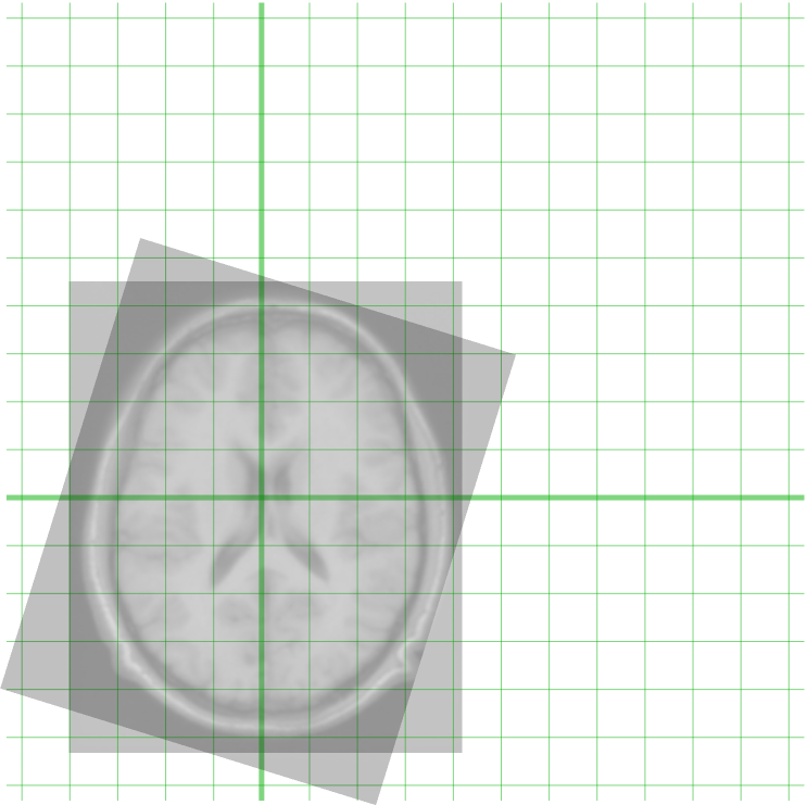
Image registration is the process of transforming different sets of data into one coordinate system. Data may be multiple photographs, data from different sensors, times, depths, or viewpoints. It is used in computer vision, medical imaging, military automatic target recognition, and compiling and analyzing images and data from satellites. Registration is necessary in order to be able to compare or integrate the data obtained from these different measurements. Algorithm classification Intensity-based vs feature-based Image registration or image alignment algorithms can be classified into intensity-based and feature-based.A. Ardeshir Goshtasby2-D and 3-D Image Registration for Medical, Remote Sensing, and Industrial Applications Wiley Press, 2005. One of the images is referred to as the ''target'', ''fixed'' or ''sensed'' image and the others are referred to as the ''moving'' or ''source'' images. Image registration involves spatially transforming the source/moving image(s) ... [...More Info...] [...Related Items...] OR: [Wikipedia] [Google] [Baidu] |
Coordinate System
In geometry, a coordinate system is a system that uses one or more numbers, or coordinates, to uniquely determine and standardize the position of the points or other geometric elements on a manifold such as Euclidean space. The coordinates are not interchangeable; they are commonly distinguished by their position in an ordered tuple, or by a label, such as in "the ''x''-coordinate". The coordinates are taken to be real numbers in elementary mathematics, but may be complex numbers or elements of a more abstract system such as a commutative ring. The use of a coordinate system allows problems in geometry to be translated into problems about numbers and ''vice versa''; this is the basis of analytic geometry. Common coordinate systems Number line The simplest example of a coordinate system is the identification of points on a line with real numbers using the '' number line''. In this system, an arbitrary point ''O'' (the ''origin'') is chosen on a given line. The coordinate o ... [...More Info...] [...Related Items...] OR: [Wikipedia] [Google] [Baidu] |
Field Of View
The field of view (FOV) is the angle, angular extent of the observable world that is visual perception, seen at any given moment. In the case of optical instruments or sensors, it is a solid angle through which a detector is sensitive to electromagnetic radiation. It is further relevant in ''angle of view, photography''. Humans and animals In the context of human and primate vision, the term "field of view" is typically only used in the sense of a restriction to what is visible by external apparatus, like when wearing spectacles or virtual reality goggles. Note that eye movements are allowed in the definition but do not change the field of view when understood this way. If the analogy of the eye's retina working as a sensor is drawn upon, the corresponding concept in human (and much of animal vision) is the visual field. It is defined as "the number of degrees of visual angle during stable fixation of the eyes".Strasburger, Hans; Pöppel, Ernst (2002). Visual Field. In G. A ... [...More Info...] [...Related Items...] OR: [Wikipedia] [Google] [Baidu] |
3D Reconstruction
In computer vision and computer graphics, 3D reconstruction is the process of capturing the shape and appearance of real objects. This process can be accomplished either by active or passive methods. If the model is allowed to change its shape in time, this is referred to as non-rigid or spatio-temporal reconstruction. Motivation and applications The research of 3D reconstruction has always been a difficult goal. By Using 3D reconstruction one can determine any object's 3D profile, as well as knowing the 3D coordinate of any point on the profile. The 3D reconstruction of objects is a generally scientific problem and core technology of a wide variety of fields, such as Computer Aided Geometric Design ( CAGD), computer graphics, computer animation, computer vision, medical imaging, computational science, virtual reality, digital media, etc. For instance, the lesion information of the patients can be presented in 3D on the computer, which offers a new and accurate approach in diagn ... [...More Info...] [...Related Items...] OR: [Wikipedia] [Google] [Baidu] |
Point Cloud
A point cloud is a discrete set of data Point (geometry), points in space. The points may represent a 3D shape or object. Each point Position (geometry), position has its set of Cartesian coordinates (X, Y, Z). Points may contain data other than position such as RGB color spaces, RGB colors, Normal (geometry), normals, Timestamp, timestamps and others. Point clouds are generally produced by 3D scanners or by photogrammetry software, which measure many points on the external surfaces of objects around them. As the output of 3D scanning processes, point clouds are used for many purposes, including to create 3D computer-aided design (CAD) or geographic information systems (GIS) models for manufactured parts, for metrology and quality inspection, and for a multitude of visualizing, animating, rendering, and mass customization applications. Alignment and registration When scanning a scene in real world using Lidar, the captured point clouds contain snippets of the scene, which requ ... [...More Info...] [...Related Items...] OR: [Wikipedia] [Google] [Baidu] |


