|
2008 Zimbabwean Presidential Election
General elections were held in Zimbabwe on 29 March 2008 to elect the President and Parliament. Because of Zimbabwe's dire economic situation, the elections were expected to provide incumbent President Robert Mugabe with his toughest electoral challenge to date. Mugabe's opponents were critical of the handling of the electoral process, and the government was accused of planning to rig the election. Human Rights Watch said that the election was likely to be "deeply flawed.""Mugabe accused of election-rigging plan" CNN, 23 March 2008. No official results were announced for more than a month after the first round.MacDonald Dzirutwe [...More Info...] [...Related Items...] OR: [Wikipedia] [Google] [Baidu] |
Robert Mugabe
Robert Gabriel Mugabe (; ; 21 February 1924 – 6 September 2019) was a Zimbabwean revolutionary and politician who served as Prime Minister of Zimbabwe from 1980 to 1987 and then as President from 1987 to 2017. He served as Leader of the Zimbabwe African National Union (ZANU) from 1975 to 1980 and led its successor political party, the ZANU – Patriotic Front (ZANU–PF), from 1980 to 2017. Ideologically an African nationalist, during the 1970s and 1980s he identified as a Marxist–Leninist, and as a socialist after the 1990s. Mugabe was born to a poor Shona family in Kutama, Southern Rhodesia. Educated at Kutama College and the University of Fort Hare, he worked as a schoolteacher in Southern Rhodesia, Northern Rhodesia, and Ghana. Angered by white minority rule of his homeland within the British Empire, Mugabe embraced Marxism and joined African nationalists calling for an independent state controlled by the black majority. After making anti-government comments, he ... [...More Info...] [...Related Items...] OR: [Wikipedia] [Google] [Baidu] |
Harare
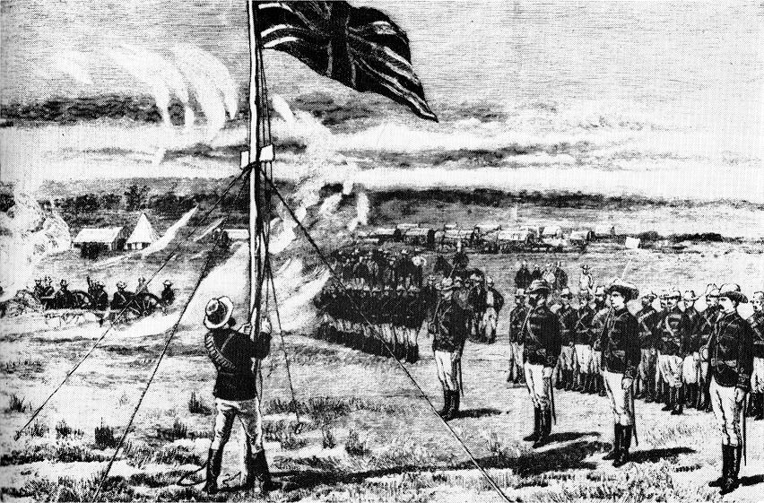
Harare (; formerly Salisbury ) is the capital and most populous city of Zimbabwe. The city proper has an area of 940 km2 (371 mi2) and a population of 2.12 million in the 2012 census and an estimated 3.12 million in its metropolitan area in 2019. Situated in north-eastern Zimbabwe in the country's Mashonaland region, Harare is a metropolitan province, which also incorporates the municipalities of Chitungwiza and Epworth. The city sits on a plateau at an elevation of above sea level and its climate falls into the subtropical highland category. The city was founded in 1890 by the Pioneer Column, a small military force of the British South Africa Company, and named Fort Salisbury after the UK Prime Minister Lord Salisbury. Company administrators demarcated the city and ran it until Southern Rhodesia achieved responsible government in 1923. Salisbury was thereafter the seat of the Southern Rhodesian (later Rhodesian) government and, between 1953 and 1963, th ... [...More Info...] [...Related Items...] OR: [Wikipedia] [Google] [Baidu] |
Gwanda South
Gwanda is a town in Zimbabwe. It is the capital of the province of Matabeleland South, one of the ten administrative provinces in the country. It is also the district capital of Gwanda District, one of the seven administrative districts in the province. Location The town is located , by road, south east of the city of Bulawayo, Zimbabwe's second largest city. This location lies on the Bulawayo–Beitbridge Road and the Beitbridge Bulawayo Railway. The town of Beitbridge, at Zimbabwe's border with the Republic of South Africa, lies approximately , further southeast on Highway A-6. The coordinates of Gwanda, Zimbabwe are: 20°56'20.0"S, 29°01'07.0"E (Latitude:-20.938889; Longitude:29.018611). Gwanda sits at an average elevation of above mean sea level. Gwanda is known to have long, hot summers, and short, cool winters. Gwanda is also quite dry as compared to the rest of the country, and is therefore prone to drought. Overview Gwanda was founded in 1900 as a settlement of E ... [...More Info...] [...Related Items...] OR: [Wikipedia] [Google] [Baidu] |
Damien Mumvuri
Damien is a given name and less frequently a surname. The name is a variation of Damian which comes from the Greek ''Damianos''. This form originates from the Greek derived from the Greek word δαμάζω (damazō), "(I) conquer, master, overcome, tame", in the form of δαμάω/-ῶ (damaō), a form assumed as the first person of δαμᾷ (damāi) Given name A *Damien Abad (born 1980), French politician *Damien Adam (born 1989), French politician *Damien Adkins (born 1981), Australian rules footballer *Damien Alamos (born 1990), French Muay Thai kickboxer * Damien Allen (born 1986), English footballer * Damien Anderson (born 1979), American football player *Damien Angove (born 1970), Australian rules footballer * Damien Arsenault, Canadian politician *Damien Atkins (born 1975), Canadian actor and playwright B *Damien Balisson (born 1996), Mauritian footballer *Damien Berry (born 1989), American football player *Damien Birkinhead (born 1993), Australian shot putter *Damien ... [...More Info...] [...Related Items...] OR: [Wikipedia] [Google] [Baidu] |
Edward Raradza
Edward Raradza is a Zimbabwean politician and tobacco farmer. He is the former vice-chairperson of the Zimbabwe Farmers Union. He was elected in the 2008 parliamentary election, as a member of the Zanu-PF for the Muzarabani South Muzarabani is a district, which is relatively flat and situated along the Mocambique-Zimbabwe border in Mashonaland Central province in Zimbabwe Zimbabwe (), officially the Republic of Zimbabwe, is a landlocked country located in South ... constituency; , AllAfrica.com, 21 June 2011, retrieved 2011-07-27 He ran unopposed. References Living people[...More Info...] [...Related Items...] OR: [Wikipedia] [Google] [Baidu] |
Muzarabani South
Muzarabani is a district, which is relatively flat and situated along the Mocambique-Zimbabwe border in Mashonaland Central province in Zimbabwe Zimbabwe (), officially the Republic of Zimbabwe, is a landlocked country located in Southeast Africa, between the Zambezi and Limpopo Rivers, bordered by South Africa to the south, Botswana to the south-west, Zambia to the north, and Mozam .... Populated places in Mashonaland Central Province {{Zimbabwe-geo-stub ... [...More Info...] [...Related Items...] OR: [Wikipedia] [Google] [Baidu] |
Bulawayo
Bulawayo (, ; Ndebele: ''Bulawayo'') is the second largest city in Zimbabwe, and the largest city in the country's Matabeleland region. The city's population is disputed; the 2022 census listed it at 665,940, while the Bulawayo City Council claimed it to be about 1.2 million. Bulawayo covers an area of about in the western part of the country, along the Matsheumhlope River. Along with the capital Harare, Bulawayo is one of two cities in Zimbabwe that is also a province. Bulawayo was founded by a group led by Gundwane Ndiweni around 1840 as the kraal of Mzilikazi, the Ndebele king and was known as Gibixhegu. His son, Lobengula, succeeded him in the 1860s, and changed the name to kobulawayo and ruled from Bulawayo until 1893, when the settlement was captured by British South Africa Company soldiers during the First Matabele War. That year, the first white settlers arrived and rebuilt the town. The town was besieged by Ndebele warriors during the Second Matabele War. Bulawayo ... [...More Info...] [...Related Items...] OR: [Wikipedia] [Google] [Baidu] |
Matabeleland South
Matabeleland South is a province in southwestern Zimbabwe. With a population of 683,893 as of the 2012 Zimbabwean census, it is the country's least populous province. After Matabeleland North, it is Zimbabwe's second-least densely populated province. Matabeleland South was established in 1974, when the original Matabeleland Province was divided into two provinces, the other being Matabeleland North. The province is divided into six districts. Gwanda is the capital, and Beitbridge is the province's largest town. The name "Matabeleland" is derived from Ndebele, the province's largest ethnic group. Matabeleland South is bordered by Bulawayo and Matabeleland North to the north, Midlands to the northeast, Masvingo to the southeast, South Africa to the south, and Botswana to the west. It has an area of , equal to 13.86% of the total area of Zimbabwe. It is the fourth-largest of the country's ten provinces in area. Matabeleland South sits on the edge of the Kalahari Desert, giving i ... [...More Info...] [...Related Items...] OR: [Wikipedia] [Google] [Baidu] |
Matabeleland North
Matabeleland North is a Provinces of Zimbabwe, province in western Zimbabwe. With a population of 749,017 as of the Zimbabwean census, 2012, 2012 census, it is the country's second-least populous province, after Matabeleland South Province, Matabeleland South, and is the country's least densely populated province. Matabeleland North was established in 1974, when the original Matabeleland, Matabeleland Province was divided into two provinces, the other being Matabeleland South. In 1997, the province lost territory when the city of Bulawayo became its own province. Matabeleland North is divided into seven districts. Its capital is Lupane District, Lupane, and Victoria Falls, Zimbabwe, Victoria Falls and Hwange are its largest towns. The name "Matabeleland" is derived from the Matabele or Northern Ndebele people, Ndebele people, the province's largest ethnic group. Matabeleland North is bordered by Matabeleland South and Bulawayo to the south, Midlands Province, Midlands to the east, ... [...More Info...] [...Related Items...] OR: [Wikipedia] [Google] [Baidu] |
Masvingo
Masvingo is a city in south-eastern Zimbabwe and the capital of Masvingo Province. The city is situated close to Great Zimbabwe, the national monument from which the country takes its name and close to Lake Mutirikwi, its recreational park, the Kyle dam and the Kyle National Reserve where there are many different animal species. It is mostly populated by the Karanga people who form the biggest branch of the various Shona tribes in Zimbabwe. History The city was known as Fort Victoria until 1982, when its name was briefly changed to Nyanda, after a mountain about 10 kilometres south of the town, on the Masvingo to Beitbridge Road. That led to protests, because "nyanda" means "one who has lice", and public sentiment was that Masvingo would be more reflective of the history of the city. Within a few months, the name was changed to Masvingo, which means "fort" in Shona, and the Great Zimbabwe, which is essentially a walled fort, is often referred to as "Masvingo eZimbabwe" or som ... [...More Info...] [...Related Items...] OR: [Wikipedia] [Google] [Baidu] |
Mashonaland West
Mashonaland West is a province of Zimbabwe. It has an area of 57,441 km² and a population of approximately 1.5 million (2012). Chinhoyi is the capital of the province. Districts Mashonaland West is divided into 7 districts: * Chegutu * Hurungwe * Kariba * Makonde * Mhondoro-Ngezi * Sanyati * Zvimba Geography See also *Provinces of Zimbabwe *Districts of Zimbabwe The Republic of Zimbabwe is broken down into 10 administrative provinces, which are divided into 59 districts and 1,200 wards. Bulawayo Province * Bulawayo Harare Province * Harare Manicaland Province * Buhera * Chima ... References {{Zimbabwe-gov-stub Provinces of Zimbabwe ... [...More Info...] [...Related Items...] OR: [Wikipedia] [Google] [Baidu] |
Mashonaland East
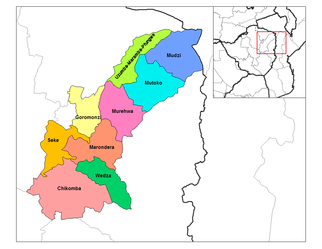
Mashonaland East, informally Mash East, is a province of Zimbabwe. It has an area of 32,230 km2 and a population of approximately 1.35 million (2012). Marondera is the capital of the province. Geography Districts Mashonaland East is divided into nine districts: * Chikomba * Goromonzi * Marondera * Mudzi * Murehwa (Mrehwa) * Mutoko * Seke * Uzumba-Maramba-Pfungwe (UMP) * Wedza (Hwedza) Education See also * Provinces of Zimbabwe * Districts of Zimbabwe The Republic of Zimbabwe is broken down into 10 administrative provinces, which are divided into 59 districts and 1,200 wards. Bulawayo Province * Bulawayo Harare Province * Harare Manicaland Province * Buhera * Chima ... Notes External links * Provinces of Zimbabwe {{Zimbabwe-gov-stub ... [...More Info...] [...Related Items...] OR: [Wikipedia] [Google] [Baidu] |
.jpg)


