|
2007 Sumatra Earthquakes (other)
{{Disambiguation ...
2007 Sumatra earthquakes may refer to: * March 2007 Sumatra earthquakes * September 2007 Sumatra earthquakes See also *List of earthquakes in Indonesia __NOTOC__ This is an incomplete list of more recent recorded major earthquakes that have occurred within the boundaries of Indonesia. The determinants of the activity are indicated by the geology of the region, and the volcanic activity. Large nu ... [...More Info...] [...Related Items...] OR: [Wikipedia] [Google] [Baidu] |
March 2007 Sumatra Earthquakes
The March 2007 Sumatra earthquakes occurred near the northern end of Lake Singkarak in Sumatra, Indonesia, on March 6. The first shock in this earthquake doublet struck with a maximum Mercalli intensity of VIII (''Severe'') and the second shock that arrived two hours later had a maximum Mercalli intensity of VI (''Strong''). Earthquakes The initial quake at 10:49 (03:49 UTC) measured 6.4 on the moment magnitude scale and the second quake at 12:49 (05:49 UTC) measured 6.3. The earthquakes were felt as far away as Singapore and Malaysia, which prompted the evacuation of some buildings there. Effects Over 60 fatalities and 460 serious injuries have been reported, spread across many towns and regencies in West Sumatra. Over 43,000 houses were damaged, with over 12,000 of those severely damaged. The severe damage to other structures includes over 130 public facilities, 310 mosques, 60 government buildings, 370 schools, and 230 shops. According to the governor of West Sumatra, ... [...More Info...] [...Related Items...] OR: [Wikipedia] [Google] [Baidu] |
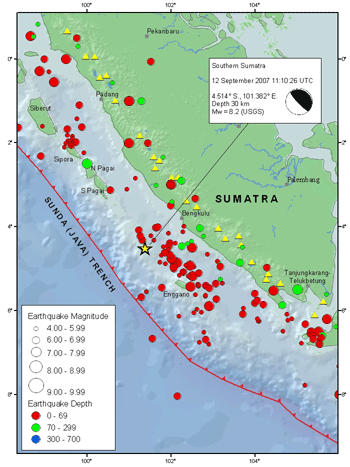
September 2007 Sumatra Earthquakes
The September 2007 Sumatra earthquakes were a series of megathrust earthquakes that struck the Sunda Trench off the coast of Sumatra, Indonesia, with three of magnitude 7 or greater. A series of tsunami bulletins was issued for the area. The most powerful of the series had a magnitude of 8.5, which makes it in the top 20 of the largest earthquakes ever recorded on a seismograph. Timeline The first earthquake occurred at 11:10:26 UTC (18:10 local time) on 12 September 2007, and was an 8.5 earthquake on the moment magnitude scale. It had a focal depth of 34 km, at , about 130 km southwest of Bengkulu on the southwest coast of Sumatra, Indonesia, and some 600 km west-northwest of Indonesia's capital city, Jakarta. It was followed by several earthquakes of magnitude 5 through 6 along the same fault, west of Sumatra. The second largest earthquake, 7.9 Mw, occurred later the same day at 23:49:04 UTC (06:49:04 local time the following day). It was centred ... [...More Info...] [...Related Items...] OR: [Wikipedia] [Google] [Baidu] |

