|
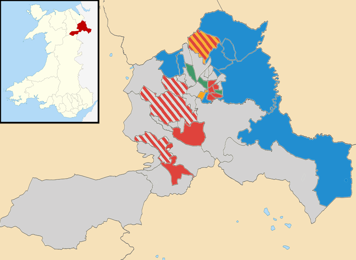
2017 Wrexham County Borough Council Election
The 2017 Wrexham County Borough Council election took place on 4 May 2017 to elect members of Wrexham County Borough Council in Wales. This was on the same day as other 2017 United Kingdom local elections. The previous all-council election took place in May 2012. Background The Labour Party held power on the council after the 2012 election, but lost it after splitting because of an internal row. Several Labour councillors became independent, allowing the Independent group to take control in alliance with the Conservatives. In 2017, contests took place in 44 of the 47 wards. Results The Independents lost three seats in comparison with their position immediately prior to the election, but remained the largest group. The Conservative group gained four seats. A coalition of the Independent group, the Wrexham Independents group and the Conservatives agreed to run the council for the next 5 years to 2022. Ward results * = denotes councillor elected to this ward at the ... [...More Info...] [...Related Items...] OR: [Wikipedia] [Google] [Baidu] |
Wrexham County Borough Council 2017 Election Results Map
Wrexham ( ; cy, Wrecsam; ) is a city and the administrative centre of Wrexham County Borough in Wales. It is located between the Welsh mountains and the lower Dee Valley, near the border with Cheshire in England. Historically in the county of Denbighshire, and later the county of Clwyd in 1974, it has been the principal settlement of Wrexham County Borough since 1996. Wrexham has historically been one of the primary settlements of Wales. At the 2011 Census, it had an urban population of 61,603 as part of the wider Wrexham built-up area which made it Wales's fourth largest urban conurbation and the largest in north Wales. The city comprises the local government communities of Acton, Caia Park, Offa and Rhosddu. Wrexham's built-up area extends further into villages like Bradley, Brymbo, Brynteg, Gwersyllt, New Broughton, Pentre Broughton and Rhostyllen. Wrexham was likely founded prior to the 11th century and developed in the Middle Ages as a regional centre for trade and ... [...More Info...] [...Related Items...] OR: [Wikipedia] [Google] [Baidu] |
Esclusham
Esclusham ( cy, Esclus or ''Esclys'') is a community and electoral ward in Wrexham County Borough, Wales. The community includes the villages of Bersham, Rhostyllen, Aberoer, Llwyneinion and Pentre Bychan, as well as a number of smaller settlements, the park at Erddig, and an area of the Ruabon Moors west of Aber-oer known as Esclusham Mountain. The population of the community at the 2011 Census was 3,515. History The name is recorded as Esclesham or Esclusham as early as 1315, likely originating in a combination of the Old English personal name ''Æscel'' with ''ham'', "settlement"; the name is locally pronounced with stress on the second (middle) syllable, probably due to the influence of Welsh language stress patterns.''Nomina'', v. 11-13, 1987, 102 The old township of Esclusham, within the manor of Esclusham, was part of the historic Marcher Lordship of Bromfield and Yale. The ''Survey'' of topographer John Norden, carried out in 1620 within Bromfield and Yale, ... [...More Info...] [...Related Items...] OR: [Wikipedia] [Google] [Baidu] |
Ponciau
Ponciau is a village within the community of Rhosllanerchrugog, Wrexham County Borough, Wales. It is close to the villages of Legacy, Pentre Bychan and Johnstown and is overlooked by Ruabon Mountain. The village name is also applied to a larger electoral ward, whose population at the 2011 Census was 4,842. Etymology The Welsh word ''ponc'', plural ''ponciau'', means "bank" or "hillock", and the village probably takes its name from the large number of spoil tips which formerly covered the area. The village name was spelt using the form "Ponkey" until 1932, when the villagers convened a meeting to petition for its change to ''Ponciau'', feeling the earlier spelling to be ugly in addition to inaccurately representing Welsh language phonetics.''Rhos Herald'', 13 Sep 1932''Wrexham Leader'', 30 Sep 1932 While this was based on a belief that "Ponkey" was an anglicised spelling, it in fact probably reflected a local pronunciation of the word in the dialect of Denbighshire, where ... [...More Info...] [...Related Items...] OR: [Wikipedia] [Google] [Baidu] |
Plas Madoc
Plas Madoc ( cy, Plas Madog) is a housing estate and former electoral ward near Acrefair, in the Cefn community in Wrexham County Borough, Wales. It is located seven miles to the south-west of Wrexham, and contains The Land adventure playground, and a community-run leisure centre with a swimming pool. The area is one of the most deprived areas (top 10% most deprived) in Wales, and the fourth most deprived LSOA in Wrexham County Borough. Plas Madoc F.C. was a football club in the area, the club dissolved in 2020. History The land that the housing estate now stands on was once part of the Chirk Estate. Between 1677 and 1678, there was an ironworks including a charcoal-fired blast furnace situated on the site, although the precise location of the blast furnace has not been determined. The furnace had an annual output of in 1711, and between 1757 and 1761 (or potentially earlier), there could have been a site for Coke smelting. The site was developed by the Lloyd family o ... [...More Info...] [...Related Items...] OR: [Wikipedia] [Google] [Baidu] |
Pen-y-cae, Wrexham
Pen-y-cae is a village and Community (Wales), community in Wrexham County Borough, Wales. The population of the community taken at the United Kingdom 2011 Census, 2011 census was 3,389. It adjoins the larger village of Rhosllanerchrugog. Etymology Pen-y-cae means 'head of the field' or 'end of the field'. It is not an uncommon name, with three other settlements in Wales having the same name: *Pen-y-cae, Powys *Bridgend, Pen-y-cae, Bridgend *Neath Port Talbot, Pen-y-cae, Neath Port Talbot Although often written as one word without hyphens, in its correct form the name is hyphenised due to the definite article 'y' preceding a single-syllable element. History The village was part of the ancient parish of Ruabon and the district was known as ''Dynhinlle Uchaf'' (but also known as ''Y Dref Fechan'' or ''Cristionydd Fechan''). The new parish of Pen-y-cae was formed 1879, from parts of the existing parishes of Ruabon, Rhosllanerchrugog and Rhosymedre. St Thomas' Church Pen ... [...More Info...] [...Related Items...] OR: [Wikipedia] [Google] [Baidu] |
Overton-on-Dee
Overton ( cy, Owrtyn) or Overton-on-Dee is a village and community in Wrexham County Borough, Wales. It is situated close to the Welsh-English border on the edge of an escarpment that winds its way around the course of the River Dee, from which Overton-on-Dee derives its name. The community of Overton, which also includes the village of Lightwood Green and a number of small hamlets including Knolton, had a total population of 1,276 at the 2001 census,Overton Community Office for National Statistics increasing to 1,382 at the 2011 Census. Geography Overton is from ...[...More Info...] [...Related Items...] OR: [Wikipedia] [Google] [Baidu] |
Offa, Wrexham
Offa is a community and electoral ward in Wrexham County Borough, Wales, covering most of the south-western portion of the city of Wrexham. It is bordered by the communities of; Rhosddu, and Caia Park to the north, Abenbury to the east, Esclusham, and Marchwiel to the south, and Broughton, Coedpoeth, and Gwersyllt to the west. Naming According to Howard Williams and Liam Delaney, a Professor of Archaeology and Doctoral Researcher respectively, at the University of Chester, the area is named after Bryn Offa (Welsh for Offa's Hill), a housing estate and former hall located currently within the community. Bryn Offa itself is actually named after Wat's Dyke which historically passes through the community, as historically there was no distinction between Wat's and Offa's Dyke, leading to local confusion. Williams and Delaney state that such distinction between the two dykes was only made by at least the nineteenth century. History Unlike many such community areas in Wales, O ... [...More Info...] [...Related Items...] OR: [Wikipedia] [Google] [Baidu] |
Minera
Minera ( cy, Mwynglawdd; ) is a village and community in Wrexham County Borough, Wales. It adjoins the village of Coedpoeth. The community, which in addition to Minera village includes a number of smaller hamlets such as Gwynfryn and New Brighton and large areas of farmland, had a total population of 1,608 at the 2001 census,Minera Office for National Statistics increasing slightly to 1,617 at the 2011 Census. History The name Minera has an unusual source, being derived from the for "mine" or "ore".Palmer, A. N. ''A History of Ancient Tenures of Land ...[...More Info...] [...Related Items...] OR: [Wikipedia] [Google] [Baidu] |
Marford And Hoseley
Marford is a village in Wrexham County Borough, Wales, near the Wales-England border. Marford covers some , where the hills of north-east Wales meet the Cheshire Plain. Distant landmarks that can be seen clearly from Marford include Eaton Hall, Chester Town Hall and Cathedral. Beyond that on the Cheshire plains, Peckforton Castle and its hills form the skyline, with the outcrop of rock at Beeston Castle. History Marford was formerly always pronounced and spelt ''Merford'', and continued to be written as such on the township rate books until 1804.Palmer, A. N. ''A History of Ancient Tenures of Land in North Wales...'', 1910, p.235 The name is English in origin, and may mean either the "ford of the mere", or refer to "mere" in its alternative sense of "boundary". The Rofft was the site of an Iron Age hill fort and later a motte and bailey castle. Due to the history of the Rofft no physical remains are visible at the site. At the time of Domesday Merford was part of the English ... [...More Info...] [...Related Items...] OR: [Wikipedia] [Google] [Baidu] |
Marchwiel
Marchwiel ( cy, Marchwiail) is a village and community in Wrexham County Borough, Wales. It is about 2 miles south-east of Wrexham city on the A525 road towards Bangor-on-Dee. The community has an area of 1,488 hectares and a population of 1,418 ( 2001 census), the population falling to 1,379 at the 2011 Census. There are several large country houses in the area including Marchwiel Hall, Bryn-y-grog, Old Sontley and Erddig Hall, now a National Trust property and a popular tourist attraction. The 19th century, Marchwiel Hall was acquired by Sir Alfred McAlpine, founder of Alfred McAlpine and son of 'Concrete' Bob McAlpine. In the Middle Ages there was a church at Marchwiel dedicated to Saint Deiniol. It was recorded in early times as ''Plwyf y Marchwiail'', "the parish of the saplings";''Archaeologia Cambrensis'', 1917, 308 this is sometimes taken to refer to the materials used to build the first church. The current church building dates from 1778 and is dedicated to Saint ... [...More Info...] [...Related Items...] OR: [Wikipedia] [Google] [Baidu] |
Llay
Llay ( cy, Llai; meaning meadow; ) is a village and community in Wrexham County Borough, Wales. It borders several other villages including Gwersyllt and Gresford. At the 2001 Census, the total population of the community of Llay, including Llay village, was 4,905, reducing to 4,814 at the 2011 Census. Prior to the 1960s, Llay was a coal mining village. Llay Main Colliery, at one time the largest colliery in Wales and after 1952 the deepest pit in the UK, was a major employer for the area before its coal reserves were exhausted in 1966.Llay Main Colliery BBC North East Wales History Llay first appears in mediaeval records as a - a small settlement wit ...[...More Info...] [...Related Items...] OR: [Wikipedia] [Google] [Baidu] |
Llangollen Rural
Llangollen Rural ( cy, Llangollen Wledig) is a community and electoral ward in Wrexham County Borough, Wales. It contains the villages of Froncysyllte, Garth, and Trevor, and had a population of 1,999 at the 2001 census,Llangollen Rural Office for National Statistics increasing to 2,059 at the 2011 Census. The aqueduct is a . Although named Rural, it is actually densely populated. The area was, until 1974, the ... [...More Info...] [...Related Items...] OR: [Wikipedia] [Google] [Baidu] |


