|
1928 United States Senate Election In Maryland
The 1928 United States Senate election in Maryland was held on November 5, 1928. Incumbent Democratic Senator William Cabell Bruce ran for re-election to a second term in office, but was defeated by Republican former Governor Phillips Lee Goldsborough, who had been a failed candidate for Senate in 1916. Democratic primary Candidates * William Cabell Bruce, incumbent Senator since 1923 * Virginia Peters-Parkhurst Results General election Results Results by county Counties that flipped from Democrat to Republican *Anne Arundel * Baltimore (County) * Caroline * Carroll *Frederick *Kent * Montgomery * Prince George's *Somerset *Talbot *Washington * Wicomico *Worcester Counties that flipped from Republican to Democrat * Queen Anne's See also * 1928 United States Senate elections *1928 United States elections References Notes {{Maryland elections 1929 Maryland United States Senate The United States Senate is the upper chamber of the United Stat ... [...More Info...] [...Related Items...] OR: [Wikipedia] [Google] [Baidu] |
Phillips Lee Goldsborough
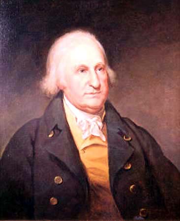
Phillips Lee Goldsborough I (August 6, 1865October 22, 1946), was an American Republican Party (United States), Republican politician and member of the United States Senate representing Maryland, State of Maryland from 1929 to 1935. He was also the List of Governors of Maryland, 47th Governor of Maryland from 1912 to 1916 and Comptroller of the Maryland Treasury from 1898 to 1900. To date, he is the last Republican to serve as Comptroller of Maryland. Early life and career Goldsborough was born in Princess Anne, Maryland and was educated in public and private schools. While working as a clerk for the United States Navy, he studied law and was admitted to the bar in 1886, commencing practice in Cambridge, Maryland soon thereafter. He also held an interest in banking. In 1893 he married Mary Ellen Showell (c. 1865 – 1930) and they had two sons: Brice W. Goldsborough; and Phillips Lee Goldsborough II. In 1891 and in 1895, Goldsborough was elected state's attorney for Dorches ... [...More Info...] [...Related Items...] OR: [Wikipedia] [Google] [Baidu] |
Howard County, Maryland
Howard County is located in the U.S. state of Maryland. As of the 2010 census, the population was 287,085. As of the 2020 census its population rose to 328,200. Its county seat is Ellicott City. Howard County is included in the Baltimore-Columbia-Towson, MD Metropolitan Statistical Area, which is also part of the larger Washington-Baltimore-Arlington, DC-MD-VA-WV-PA Combined Statistical Area. Recent south county development has led to some realignment towards the Washington, D.C. media and employment markets. The county is home to Columbia, a major planned community of approximately 100,000 founded in 1967. Howard County is frequently cited for its affluence, quality of life, and excellent schools. Its estimated 2016 median household income of $120,194 raised it to the second-highest median household income of any U.S. county. Many of the most affluent communities in the area, such as Clarksville, Dayton, Glenelg, Glenwood, and West Friendship, are located along the ... [...More Info...] [...Related Items...] OR: [Wikipedia] [Google] [Baidu] |
1928 United States Elections
The 1928 United States elections was held on November 6. In the last election before the start of the Great Depression, the Republican Party retained control of the presidency and bolstered their majority in both chambers of Congress. Republican former Secretary of Commerce Herbert Hoover defeated Democratic nominee New York Governor Al Smith. Hoover won a landslide victory, taking several Southern states and winning almost every state outside the South. Democrats suffered from voter prejudice against Roman Catholics like Smith. As incumbent President Calvin Coolidge declined to seek re-election, Hoover won the Republican nomination on the first ballot. Like Hoover, Smith also won his party's nomination on the first ballot. The Republicans gained thirty-two seats in the House of Representatives, furthering a majority over the Democrats. The Republicans also increased a majority in the Senate, gaining eight seats. See also *1928 United States presidential election * 1928 ... [...More Info...] [...Related Items...] OR: [Wikipedia] [Google] [Baidu] |
1928 United States Senate Elections
The 1928 United States Senate elections were elections that coincided with the presidential election of Republican Herbert Hoover. The strong economy helped the Republicans to gain seven seats from the Democrats. Senate Majority leader, Republican Charles Curtis of Kansas, was not up for election this cycle, but he was elected U.S. Vice President. He resigned March 3, 1929, so his seat was vacant at the beginning of the next Congress (March 4, 1929) until April 1, 1929, when a Republican was appointed to continue the term. Gains and losses Republicans gained five seats by defeating five Democratic incumbents: # Delaware: Democratic incumbent Thomas F. Bayard Jr. lost re-election to Republican challenger John G. Townsend Jr. # Maryland: Democratic incumbent William Cabell Bruce lost re-election to Republican challenger Phillips Lee Goldsborough. # New Jersey: Democratic incumbent Edward I. Edwards lost re-election to Republican challenger Hamilton Fish Kean. # Rhode Island: D ... [...More Info...] [...Related Items...] OR: [Wikipedia] [Google] [Baidu] |
Worcester County, Maryland
Worcester County is the easternmost county of the U.S. state of Maryland. As of the 2020 census, the population was 52,460. Its county seat is Snow Hill. It is the only county of Maryland that borders the Atlantic Ocean, and the only county bordering both Delaware and Virginia. The county was named for Mary Arundell, the wife of Sir John Somerset, a son of Henry Somerset, 1st Marquess of Worcester. She was sister to Anne Arundell (Anne Arundel County), wife of Cecil Calvert, 2nd Baron Baltimore (Cecil County), the first Proprietor and Proprietary Governor of the Province of Maryland. Worcester County is included in the Salisbury, MD- DE Metropolitan Statistical Area. The county includes the entire length of the state's ocean and tidewater coast along the Intracoastal Waterway bordering Assawoman Bay, Isle of Wight Bay, Sinepuxent Bay, and Chincoteague Bay between the sand barrier islands of Fenwick Island and Assateague Island bordering the Atlantic Ocean coast. It is h ... [...More Info...] [...Related Items...] OR: [Wikipedia] [Google] [Baidu] |
Wicomico County, Maryland
Wicomico County () is located in the southeastern part of the U.S. state of Maryland, on the Delmarva Peninsula. As of the 2020 census, the population was 103,588. The county seat is Salisbury. The county was named for the Wicomico River, which in turn derives from Algonquian language words , meaning "a place where houses are built," apparently referring to a Native American town on the banks. Wicomico County is included in the Salisbury, MD-DE Metropolitan Statistical Area. The newspaper of record is ''The Daily Times.'' History Wicomico County was created from Somerset and Worcester counties in 1867. Politics and government Wicomico County was granted a charter form of government in 1964. In the period after the Reconstruction era, Wicomico County became solidly Democratic due to its strong support for secession and state efforts to disenfranchise most blacks by raising barriers to voter registration. Independent insurgent white groups worked to intimidate and discoura ... [...More Info...] [...Related Items...] OR: [Wikipedia] [Google] [Baidu] |
Washington County, Maryland
Washington County is located in the western part of the U.S. state of Maryland. As of the 2020 census, the population was 154,705. Its county seat is Hagerstown. Washington County was the first county in the United States to be named for the Revolutionary War general (and later President) George Washington. Washington County is one of three Maryland counties recognized by the Appalachian Regional Commission as being part of Appalachia. The county borders southern Pennsylvania to the north, Northern Virginia to the south, and the Eastern Panhandle of West Virginia to the south and west. Washington County is included in the Hagerstown- Martinsburg, MD- WV Metropolitan Statistical Area, which is also included in the Washington-Baltimore- Arlington, DC-MD- VA-WV- PA Combined Statistical Area. History The western portions of the Province of Maryland (including present Washington County) were incorporated into Prince George's County in 1696. This original county included six cu ... [...More Info...] [...Related Items...] OR: [Wikipedia] [Google] [Baidu] |
Talbot County, Maryland
Talbot County is located in the heart of the Eastern Shore of Maryland in the U.S. state of Maryland. As of the 2020 United States Census, 2020 census, the population was 37,526. Its county seat is Easton, Maryland, Easton. The county was named for Lady Grace Talbot, the wife of Robert Talbot (statesman), Sir Robert Talbot, an Anglo-Ireland, Irish statesman, and the sister of Cecilius Calvert, 2nd Baron Baltimore, Lord Baltimore. Talbot County comprises the Easton, MD Micropolitan Statistical Area, which is also included in the Washington, D.C., Washington–Baltimore–Arlington County, Virginia, Arlington, DC–MD–Virginia, VA–West Virginia, WV–Pennsylvania, PA Baltimore–Washington metropolitan area, Combined Statistical Area. Talbot County is bordered by Queen Anne's County, Maryland, Queen Anne's County to the north, Caroline County, Maryland, Caroline County to the east, Dorchester County, Maryland, Dorchester County to the south, and the Chesapeake Bay to the west. ... [...More Info...] [...Related Items...] OR: [Wikipedia] [Google] [Baidu] |
Somerset County, Maryland
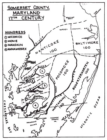
Somerset County is the southernmost county in the U.S. state of Maryland. As of the 2020 census, the population was 24,620, making it the second-least populous county in Maryland. The county seat is Princess Anne. The county was named for Mary, Lady Somerset, the wife of Sir John Somerset and daughter of Thomas Arundell, 1st Baron Arundell of Wardour (c. 1560–1639). She was also the sister of Anne Calvert, Baroness Baltimore (1615–1649), who later lent her name to Anne Arundel County, which was erected in 1650 as the Province of Maryland's third county. Somerset County is located on the state's Eastern Shore. It is included in the Salisbury, MD- DE Metropolitan Statistical Area. The University of Maryland Eastern Shore is located in Princess Anne. History Initial settlements Somerset County was settled and established by English colonists in part due to a response to the Province/Dominion of Virginia passing a law in 1659/1660 requiring Quakers in the colony to convert ... [...More Info...] [...Related Items...] OR: [Wikipedia] [Google] [Baidu] |
Queen Anne's County, Maryland
Queen Anne's County is located on the Eastern Shore of the U.S. state of Maryland. As of the 2020 census, the population was 49,874. Its county seat and most populous municipality is Centreville. The census-designated place of Stevensville is the county's most populous place. The county is named for Queen Anne of Great Britain, who reigned when the county was established in 1706 during the colonial period. Queen Anne's County is included in the Baltimore-Columbia-Towson, MD Metropolitan Statistical Area, which is also included in the Washington-Baltimore-Arlington, DC-MD-VA-WV-PA Combined Statistical Area, and is the easternmost in both. The Chesapeake Bay Bridge connects Queen Anne County of the Eastern Shore to Anne Arundel County on the Western Shore. The American Discovery Trail runs through the county. History Queen Anne's County has two hundred sixty-five miles of waterfront, much of that being the shores of Kent Island, which stands out from the eastern shore of th ... [...More Info...] [...Related Items...] OR: [Wikipedia] [Google] [Baidu] |
Prince George's County, Maryland
) , demonym = Prince Georgian , ZIP codes = 20607–20774 , area codes = 240, 301 , founded date = April 23 , founded year = 1696 , named for = Prince George of Denmark , leader_title = Executive , leader_name = Angela D. Alsobrooks ( D) , seat wl = Upper Marlboro , largest city wl = Bowie , area_total_sq_mi = 499 , area_land_sq_mi = 483 , area_water_sq_mi = 16 , area percentage = 3.2 , census yr = 2020 , pop = 967201 , pop_est_as_of = 2021 , population_est = , density_sq_mi = 1900 , district = 4th , district2 = 5th , time zone = Eastern , web = www.princegeorgescountymd.gov Prince George's County (often shortened to PG County) is a county located in the U.S. state of Maryland bordering the eastern portion of Washington, D.C. As of the 2020 U.S. census, the population was 967,201, making it the second-most populous county in Maryland, behind Montgomery County. The 2020 census counted an increase of nearly 104,000 in the previous ten years. Its c ... [...More Info...] [...Related Items...] OR: [Wikipedia] [Google] [Baidu] |
Montgomery County, Maryland
Montgomery County is the most populous county in the state of Maryland. As of the 2020 census, the county's population was 1,062,061, increasing by 9.3% from 2010. The county seat and largest municipality is Rockville, although the census-designated place of Germantown is the most populous place within the county. Montgomery County, which adjoins Washington, D.C., is part of the Washington–Arlington–Alexandria, DC–VA–MD–WV metropolitan statistical area, which in turn forms part of the Baltimore–Washington combined statistical area. Most of the county's residents live in unincorporated locales, of which the most urban are Silver Spring and Bethesda, although the incorporated cities of Rockville and Gaithersburg are also large population centers, as are many smaller but significant places. The average household income in Montgomery County is among the highest in the United States. It has the highest percentage (29.2%) of residents over 25 years of age who hold po ... [...More Info...] [...Related Items...] OR: [Wikipedia] [Google] [Baidu] |


.png)


.png)